Enable Location

We need your location to show you interesting places around you

Discover nearby places

Find interesting locations and hidden gems around you

Precise directions

Get accurate directions and distances to places

Your location is never shared with other users. It's only used when you tap the location button.

Touchet Formation

Log in to your account

Start exploring — it's free

Trusted by 62,901 travelers worldwide

Continue with Google
Continue with Apple
or

We will send you a code to connect

By continuing, you accept our Terms and Conditions and our Privacy Policy

Check your inbox

We've sent a pincode in your inbox. Please enter the code below.

Touchet Formation
Discussion Reviews 1 Photos
4.5k Popularity

Touchet Formation, Geological formation in south-central Washington, United States.

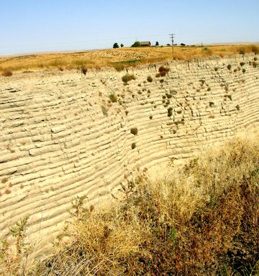
The Touchet Formation is a geological formation in south-central Washington displaying stacked layers of sediment up to 330 feet (100 meters) thick. The visible deposits show alternating bands of coarser and finer materials created by repeated sedimentation events.

Richard Foster Flint first documented this formation in 1938 at the confluence of Touchet River and Walla Walla River. The layers formed through repeated flooding events that occurred thousands of years ago.

The formation provides educational opportunities for geology students to study sedimentary processes and flooding patterns through field observations and research activities.

The formation can be viewed at multiple locations including highway cuts and river valley areas west of Walla Walla. Visitors should prepare for uneven terrain and bring appropriate clothing for outdoor conditions.

The layers contain between 40 and 62 separate rhythmites, each marking an individual flood event from an ancient glacial lake. Each thin band tells the story of a single prehistoric flood episode.

The community of curious travelers

AroundUs brings together thousands of curated places, local tips, and hidden gems, enriched daily by 60,000 contributors worldwide.

Start exploring
Location
GPS coordinates
46.03310,-118.68400
Latest update
December 10, 2025 20:08
Around this place
Eastern Oregon Correctional Institution
United States of America

Eastern Oregon Correctional Institution

41.6 km
Wallula Gap
United States of America

Wallula Gap

20.4 km
Fort Walla Walla
United States of America

Fort Walla Walla

25.3 km
Ice Harbor Dam
United States of America

Ice Harbor Dam

28.5 km
Cable Bridge
United States of America

Cable Bridge

38.4 km
Fort Nez Percés
United States of America

Fort Nez Percés

18.3 km
Blue Bridge
United States of America

Blue Bridge

40.9 km
Sacajawea State Park
United States of America

Sacajawea State Park

33.2 km
Hat Rock State Park
United States of America

Hat Rock State Park

39.5 km
Clover Island
United States of America

Clover Island

38.8 km
Borleske Stadium
United States of America

Borleske Stadium

27.3 km
Cold Springs National Wildlife Refuge
United States of America

Cold Springs National Wildlife Refuge

40.6 km
Pendleton Round-Up and Happy Canyon Hall of Fame
United States of America

Pendleton Round-Up and Happy Canyon Hall of Fame

41.5 km
Kirkman House
United States of America

Kirkman House

26.9 km
Pendleton Center for the Arts
United States of America

Pendleton Center for the Arts

40.7 km
Electric Light Works Building
United States of America

Electric Light Works Building

26.4 km
John F. Kilkenny United States Post Office and Courthouse
United States of America

John F. Kilkenny United States Post Office and Courthouse

41.1 km
Greasewood Finnish Apostolic Lutheran Church
United States of America

Greasewood Finnish Apostolic Lutheran Church

28.7 km
Spare Time Lanes
United States of America

Spare Time Lanes

39.3 km
Clover Island Light
United States of America

Clover Island Light

38.8 km
Pendleton Underground Tours Gift Shop
United States of America

Pendleton Underground Tours Gift Shop

41.1 km
Walla Walla Valley Traction Company Car Barn
United States of America

Walla Walla Valley Traction Company Car Barn

25.6 km
Franklin County Courthouse
United States of America

Franklin County Courthouse

39 km
Children's Museum of Walla Walla
United States of America

Children's Museum of Walla Walla

25.3 km
Liberty Theatre
United States of America

Liberty Theatre

27 km
Athena City Park
United States of America

Athena City Park

29.2 km
Centre Theatre
United States of America

Centre Theatre

41.1 km
Keewaydin Park
United States of America

Keewaydin Park

38.7 km
Show the full map
« Touchet Formation - Geological formation in south-central Washington, United States » is provided by Around Us (aroundus.com). Images and texts are derived from Wikimedia project under a Creative Commons license. You are allowed to copy, distribute, and modify copies of this page, under the conditions set by the license, as long as this note is clearly visible.

Discover hidden gems everywhere you go!

From secret cafés to breathtaking viewpoints, skip the crowded tourist spots and find places that match your style. Our app makes it easy with voice search, smart filtering, route optimization, and insider tips from travelers worldwide. Download now for the complete mobile experience.

Around Us App Screenshot

A unique approach to discovering new places

Le Figaro

All the places worth exploring

France Info

A tailor-made excursion in just a few clicks

20 Minutes

Around Us
Travel Guide & Maps
Download

Send to your phone

QR Code
1

Open the camera app on your mobile.

2

Point at the QR code with your camera. A notification will appear.

3

Tap the notification to open the link.