Hat Rock State Park

Log in to your account

AroundUs is a community-driven map of interesting places, built by curious explorers like you. It grows with every review, story, and photo you share.
Connect to save your favorite spots, contribute locations, and create personalized routes.
Continue with Google
Continue with Apple
Continue with X
Continue with Facebook
Continue with email
By continuing, you accept our Terms and Conditions and our Privacy Policy
Create an account
Add to collection
Map
Suggest a change
Share

Hat Rock State Park, State park in eastern Oregon, United States.
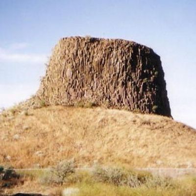
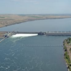
Hat Rock State Park is a state preserve in eastern Oregon centered on a distinctive basalt formation shaped like a hat, which rises above the Columbia River near Lake Wallula. The rock itself forms the primary visual landmark of the park, creating a memorable sight along the waterway.

The formation was documented by Lewis and Clark during their 1805 expedition, marking it as a key reference point along their Columbia River route. This early written record established the site as a notable landmark in regional exploration history.

This location served for generations as a fishing and gathering place for indigenous peoples of the Columbia River region, with the rock formation itself acting as a navigation marker in their seasonal routines.

The park features boat ramps and fishing locations at different points, allowing visitors to choose activities based on their interests. Accessible restrooms are located in the main areas, and the grounds remain open year-round for visitors.

The park contains a spring-fed pond that supports its own population of rainbow trout, separate from the surrounding river system. This freshwater basin offers anglers an alternative fishing environment from the main waterway.

Location: Oregon

Website: https://stateparks.oregon.gov/index.cfm?do=park.profile&parkId=12

GPS coordinates: 45.91490,-119.16500

Latest update: December 12, 2025 07:54

Photos
Around this place
McNary Dam
United States of America

McNary Dam

10.6 km
Wallula Gap
United States of America

Wallula Gap

22.2 km
Cable Bridge
United States of America

Cable Bridge

34.1 km
Fort Nez Percés
United States of America

Fort Nez Percés

27.3 km
Touchet Formation
United States of America

Touchet Formation

39.5 km
Blue Bridge
United States of America

Blue Bridge

34.6 km
Columbia River Washington Temple
United States of America

Columbia River Washington Temple

35.7 km
Sacajawea State Park
United States of America

Sacajawea State Park

33.2 km
Bateman Island
United States of America

Bateman Island

37 km
Lake Wallula
United States of America

Lake Wallula

10.6 km
Umatilla Bridge
United States of America

Umatilla Bridge

12.5 km
Clover Island
United States of America

Clover Island

33.9 km
Umatilla National Wildlife Refuge
United States of America

Umatilla National Wildlife Refuge

33.8 km
Cold Springs National Wildlife Refuge
United States of America

Cold Springs National Wildlife Refuge

5.8 km
Interstate 182 Bridge
United States of America

Interstate 182 Bridge

39.4 km
Pendleton Round-Up and Happy Canyon Hall of Fame
United States of America

Pendleton Round-Up and Happy Canyon Hall of Fame

39.5 km
REACH Museum
United States of America

REACH Museum

36 km
United States of America

Badger Mountain Centennial Preserve

37.6 km
Pendleton Center for the Arts
United States of America

Pendleton Center for the Arts

39.6 km
St. Peter's Roman Catholic Church
United States of America

St. Peter's Roman Catholic Church

19.7 km
John F. Kilkenny United States Post Office and Courthouse
United States of America

John F. Kilkenny United States Post Office and Courthouse

40 km
Echo Methodist Church
United States of America

Echo Methodist Church

19.3 km
James H. and Cynthia Koontz House
United States of America

James H. and Cynthia Koontz House

19.1 km
Bank of Echo Building
United States of America

Bank of Echo Building

19.3 km
Clover Island Light
United States of America

Clover Island Light

33.9 km
Echo City Hall
United States of America

Echo City Hall

19.4 km
Franklin County Courthouse
United States of America

Franklin County Courthouse

36.3 km
Keewaydin Park
United States of America

Keewaydin Park

32.4 km
Show the full map
Reviews

Visited this place? Tap the stars to rate it and share your experience / photos with the community! Try now! You can cancel it anytime.

« Hat Rock State Park - State park in eastern Oregon, United States » is provided by Around Us (aroundus.com). Images and texts are derived from Wikimedia project under a Creative Commons license. You are allowed to copy, distribute, and modify copies of this page, under the conditions set by the license, as long as this note is clearly visible.

Discover hidden gems everywhere you go!

From secret cafés to breathtaking viewpoints, skip the crowded tourist spots and find places that match your style. Our app makes it easy with voice search, smart filtering, route optimization, and insider tips from travelers worldwide. Download now for the complete mobile experience.

Around Us App Screenshot

A unique approach to discovering new places

Le Figaro

All the places worth exploring

France Info

A tailor-made excursion in just a few clicks

20 Minutes