Enable Location

We need your location to show you interesting places around you

Discover nearby places

Find interesting locations and hidden gems around you

Precise directions

Get accurate directions and distances to places

Your location is never shared with other users. It's only used when you tap the location button.

Lake Wallula

Log in to your account

Start exploring — it's free

Trusted by 62,304 travelers worldwide

Continue with Google
Continue with Apple
or

We will send you a code to connect

By continuing, you accept our Terms and Conditions and our Privacy Policy

Check your inbox

We've sent a pincode in your inbox. Please enter the code below.

Lake Wallula

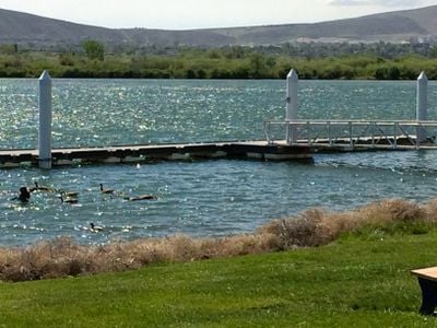
Lake Wallula, body of water

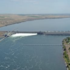
Lake Wallula is a large reservoir on the Columbia River created in 1954 by damming the river. The water body stretches for many miles with an extensive shoreline featuring beaches and access points for recreation and outdoor pursuits.

The area was shaped by the Great Missoula Floods during the Ice Age, when massive amounts of water rushed through the landscape. These ancient flood events carved the rocky cliffs and canyons that remain visible today and define the terrain.

The name Wallula comes from the Yakama people's language, reflecting the Indigenous heritage of the region. Local Native American tribes have passed down stories and oral traditions tied to this land and river for countless generations, making it a place where cultural memory remains woven into the landscape.

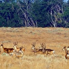
The area is easy to reach, with well-maintained roads and signs directing visitors to various access points. Summer months are ideal for swimming and boating in warm conditions, while spring and fall offer cooler weather for hiking and wildlife observation.

The area witnessed extreme natural forces - Wallula Gap is a narrow canyon where powerful flood currents raced during the Ice Age. Visitors can read the traces of this intense water movement in the distinctive rock formations visible today and understand the raw power that reshaped the land.

The community of curious travelers

AroundUs brings together thousands of curated places, local tips, and hidden gems, enriched daily by 60,000 contributors worldwide.

Start exploring
Location
Location
GPS coordinates
45.93639,-119.29778
Latest update
February 7, 2026 11:40
Around this place
Gold Coast Historic District
United States of America

Gold Coast Historic District

40.3 km
McNary Dam
United States of America

McNary Dam

95 m
Wallula Gap
United States of America

Wallula Gap

29.7 km
Cable Bridge
United States of America

Cable Bridge

34.8 km
Fort Nez Percés
United States of America

Fort Nez Percés

34.3 km
Blue Bridge
United States of America

Blue Bridge

34.5 km
Columbia River Washington Temple
United States of America

Columbia River Washington Temple

32.4 km
Sacajawea State Park
United States of America

Sacajawea State Park

35.4 km
Bateman Island
United States of America

Bateman Island

34.8 km
Hat Rock State Park
United States of America

Hat Rock State Park

10.6 km
Umatilla Bridge
United States of America

Umatilla Bridge

2.4 km
Clover Island
United States of America

Clover Island

34.4 km
Umatilla National Wildlife Refuge
United States of America

Umatilla National Wildlife Refuge

23.8 km
Cold Springs National Wildlife Refuge
United States of America

Cold Springs National Wildlife Refuge

14.1 km
Interstate 182 Bridge
United States of America

Interstate 182 Bridge

36.7 km
REACH Museum
United States of America

REACH Museum

34 km
Benton City – Kiona Bridge
United States of America

Benton City – Kiona Bridge

37.8 km
United States of America

Badger Mountain Centennial Preserve

33.3 km
Columbia River Exhibition of History, Science, and Technology
United States of America

Columbia River Exhibition of History, Science, and Technology

37.6 km
St. Peter's Roman Catholic Church
United States of America

St. Peter's Roman Catholic Church

23.1 km
Echo Methodist Church
United States of America

Echo Methodist Church

23 km
James H. and Cynthia Koontz House
United States of America

James H. and Cynthia Koontz House

22.8 km
Bank of Echo Building
United States of America

Bank of Echo Building

23 km
Clover Island Light
United States of America

Clover Island Light

34.4 km
Echo City Hall
United States of America

Echo City Hall

23.1 km
Franklin County Courthouse
United States of America

Franklin County Courthouse

36.9 km
Richland Theater
United States of America

Richland Theater

37.7 km
Keewaydin Park
United States of America

Keewaydin Park

32.9 km
Show the full map
« Lake Wallula - body of water » is provided by Around Us (aroundus.com). Images and texts are derived from Wikimedia project under a Creative Commons license. You are allowed to copy, distribute, and modify copies of this page, under the conditions set by the license, as long as this note is clearly visible.

Discover hidden gems everywhere you go!

From secret cafés to breathtaking viewpoints, skip the crowded tourist spots and find places that match your style. Our app makes it easy with voice search, smart filtering, route optimization, and insider tips from travelers worldwide. Download now for the complete mobile experience.

Around Us App Screenshot

A unique approach to discovering new places

Le Figaro

All the places worth exploring

France Info

A tailor-made excursion in just a few clicks

20 Minutes

Around Us
Travel Guide & Maps
Download

Send to your phone

QR Code
1

Open the camera app on your mobile.

2

Point at the QR code with your camera. A notification will appear.

3

Tap the notification to open the link.