Enable Location

We need your location to show you interesting places around you

Discover nearby places

Find interesting locations and hidden gems around you

Precise directions

Get accurate directions and distances to places

Your location is never shared with other users. It's only used when you tap the location button.

Cold Springs National Wildlife Refuge

Log in to your account

Start exploring — it's free

Trusted by 62,331 travelers worldwide

Continue with Google
Continue with Apple
or

We will send you a code to connect

By continuing, you accept our Terms and Conditions and our Privacy Policy

Check your inbox

We've sent a pincode in your inbox. Please enter the code below.

Cold Springs National Wildlife Refuge

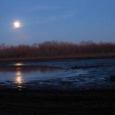
Cold Springs National Wildlife Refuge, National Wildlife Refuge in northeastern Oregon, United States

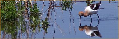
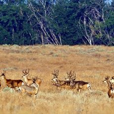
Cold Springs National Wildlife Refuge is a protected area along a reservoir featuring wetlands, open water, mudflats, and wooded areas in northeastern Oregon. The landscape spans thousands of acres and combines different habitats that support diverse wildlife throughout the seasons.

The refuge was established in 1909 under President Theodore Roosevelt as a protected area for native birds and waterfowl. This action reflected early conservation efforts in the United States.

The refuge serves as a gathering place where visitors witness migrating and resident birds in their natural habitats and learn about waterfowl conservation. People come to observe how water and land support complex ecosystems that depend on seasonal cycles and natural cycles.

The refuge is open from sunrise to sunset for visitors interested in hunting, fishing, birdwatching, or horseback riding. It is best to stay on designated paths and avoid disturbing wildlife habitats.

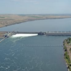
Water comes from three sources: a local creek, a river via gravity-fed canals, and a large river during dry periods. This mixed system allows the refuge to maintain water levels for wildlife when natural sources are low.

The community of curious travelers

AroundUs brings together thousands of curated places, local tips, and hidden gems, enriched daily by 60,000 contributors worldwide.

Start exploring
Location
GPS coordinates
45.86370,-119.14900
Latest update
December 12, 2025 17:40
Around this place
McNary Dam
United States of America

McNary Dam

14 km
Wallula Gap
United States of America

Wallula Gap

25.5 km
Cable Bridge
United States of America

Cable Bridge

39.6 km
Fort Nez Percés
United States of America

Fort Nez Percés

30.8 km
Touchet Formation
United States of America

Touchet Formation

40.6 km
Blue Bridge
United States of America

Blue Bridge

40.2 km
Columbia River Washington Temple
United States of America

Columbia River Washington Temple

41.6 km
Sacajawea State Park
United States of America

Sacajawea State Park

38.4 km
Hat Rock State Park
United States of America

Hat Rock State Park

5.8 km
Lake Wallula
United States of America

Lake Wallula

14.1 km
Umatilla Bridge
United States of America

Umatilla Bridge

15.4 km
Clover Island
United States of America

Clover Island

39.4 km
Umatilla National Wildlife Refuge
United States of America

Umatilla National Wildlife Refuge

35.3 km
McKay Reservoir
United States of America

McKay Reservoir

39.6 km
McKay Creek National Wildlife Refuge
United States of America

McKay Creek National Wildlife Refuge

39.8 km
Pendleton Round-Up and Happy Canyon Hall of Fame
United States of America

Pendleton Round-Up and Happy Canyon Hall of Fame

34.8 km
Pendleton Center for the Arts
United States of America

Pendleton Center for the Arts

35 km
St. Peter's Roman Catholic Church
United States of America

St. Peter's Roman Catholic Church

14.3 km
John F. Kilkenny United States Post Office and Courthouse
United States of America

John F. Kilkenny United States Post Office and Courthouse

35.4 km
Greasewood Finnish Apostolic Lutheran Church
United States of America

Greasewood Finnish Apostolic Lutheran Church

39 km
Echo Methodist Church
United States of America

Echo Methodist Church

13.9 km
James H. and Cynthia Koontz House
United States of America

James H. and Cynthia Koontz House

13.7 km
Bank of Echo Building
United States of America

Bank of Echo Building

13.9 km
Clover Island Light
United States of America

Clover Island Light

39.4 km
Echo City Hall
United States of America

Echo City Hall

14 km
Pendleton Underground Tours Gift Shop
United States of America

Pendleton Underground Tours Gift Shop

35.4 km
Franklin County Courthouse
United States of America

Franklin County Courthouse

41.8 km
Centre Theatre
United States of America

Centre Theatre

35.4 km
Show the full map
« Cold Springs National Wildlife Refuge - National Wildlife Refuge in northeastern Oregon, United States » is provided by Around Us (aroundus.com). Images and texts are derived from Wikimedia project under a Creative Commons license. You are allowed to copy, distribute, and modify copies of this page, under the conditions set by the license, as long as this note is clearly visible.

Discover hidden gems everywhere you go!

From secret cafés to breathtaking viewpoints, skip the crowded tourist spots and find places that match your style. Our app makes it easy with voice search, smart filtering, route optimization, and insider tips from travelers worldwide. Download now for the complete mobile experience.

Around Us App Screenshot

A unique approach to discovering new places

Le Figaro

All the places worth exploring

France Info

A tailor-made excursion in just a few clicks

20 Minutes

Around Us
Travel Guide & Maps
Download

Send to your phone

QR Code
1

Open the camera app on your mobile.

2

Point at the QR code with your camera. A notification will appear.

3

Tap the notification to open the link.