Enable Location

We need your location to show you interesting places around you

Discover nearby places

Find interesting locations and hidden gems around you

Precise directions

Get accurate directions and distances to places

Your location is never shared with other users. It's only used when you tap the location button.

Umatilla Bridge

Log in to your account

Start exploring — it's free

Trusted by 62,898 travelers worldwide

Continue with Google
Continue with Apple
or

We will send you a code to connect

By continuing, you accept our Terms and Conditions and our Privacy Policy

Check your inbox

We've sent a pincode in your inbox. Please enter the code below.

Umatilla Bridge
Discussion Reviews 1 Photos
3.4k Popularity

Umatilla Bridge, Road bridge connecting Umatilla County and Benton County, United States

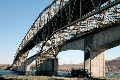
The Umatilla Bridge spans the Columbia River with two parallel structures: a steel cantilever bridge completed in 1955 and a concrete arch bridge added in 1988. Both carry Interstate 82 traffic across the river.

The project initially carried a humorous nickname from a local judge but successfully opened in 1955 with governors from both states in attendance. The second structure from the 1980s was built to handle growing traffic demand.

The bridge's name honors a ferry operator who played roles in regional community life. This naming reflects the connection between historical transportation solutions and the modern structure.

The bridge handles heavy daily traffic, so plan to cross during calmer times if possible. The dual structures allow relatively smooth traffic flow, though congestion can occur during peak hours.

For about two decades, it operated as a toll crossing, with revenue used to repay construction bonds. Once the debt was settled, management transferred completely to the states.

The community of curious travelers

AroundUs brings together thousands of curated places, local tips, and hidden gems, enriched daily by 60,000 contributors worldwide.

Start exploring
Location
Location
Inception
1955
Official opening
1955
GPS coordinates
45.92670,-119.32600
Latest update
December 12, 2025 07:58
Around this place
Gold Coast Historic District
United States of America

Gold Coast Historic District

41.6 km
McNary Dam
United States of America

McNary Dam

2.4 km
Wallula Gap
United States of America

Wallula Gap

32.1 km
Cable Bridge
United States of America

Cable Bridge

36.7 km
Fort Nez Percés
United States of America

Fort Nez Percés

36.7 km
Blue Bridge
United States of America

Blue Bridge

36.3 km
Columbia River Washington Temple
United States of America

Columbia River Washington Temple

33.6 km
Sacajawea State Park
United States of America

Sacajawea State Park

37.6 km
Bateman Island
United States of America

Bateman Island

36.3 km
Hat Rock State Park
United States of America

Hat Rock State Park

12.5 km
Lake Wallula
United States of America

Lake Wallula

2.4 km
Clover Island
United States of America

Clover Island

36.3 km
Umatilla National Wildlife Refuge
United States of America

Umatilla National Wildlife Refuge

21.5 km
Cold Springs National Wildlife Refuge
United States of America

Cold Springs National Wildlife Refuge

15.4 km
Interstate 182 Bridge
United States of America

Interstate 182 Bridge

38 km
REACH Museum
United States of America

REACH Museum

35.5 km
Benton City – Kiona Bridge
United States of America

Benton City – Kiona Bridge

38.1 km
United States of America

Badger Mountain Centennial Preserve

34.4 km
Columbia River Exhibition of History, Science, and Technology
United States of America

Columbia River Exhibition of History, Science, and Technology

38.9 km
St. Peter's Roman Catholic Church
United States of America

St. Peter's Roman Catholic Church

23 km
Echo Methodist Church
United States of America

Echo Methodist Church

22.9 km
James H. and Cynthia Koontz House
United States of America

James H. and Cynthia Koontz House

22.6 km
Bank of Echo Building
United States of America

Bank of Echo Building

22.9 km
Clover Island Light
United States of America

Clover Island Light

36.3 km
Echo City Hall
United States of America

Echo City Hall

22.9 km
Franklin County Courthouse
United States of America

Franklin County Courthouse

38.9 km
West Richland Golf Course
United States of America

West Richland Golf Course

42 km
Richland Theater
United States of America

Richland Theater

38.9 km
Show the full map
« Umatilla Bridge - Road bridge connecting Umatilla County and Benton County, United States » is provided by Around Us (aroundus.com). Images and texts are derived from Wikimedia project under a Creative Commons license. You are allowed to copy, distribute, and modify copies of this page, under the conditions set by the license, as long as this note is clearly visible.

Discover hidden gems everywhere you go!

From secret cafés to breathtaking viewpoints, skip the crowded tourist spots and find places that match your style. Our app makes it easy with voice search, smart filtering, route optimization, and insider tips from travelers worldwide. Download now for the complete mobile experience.

Around Us App Screenshot

A unique approach to discovering new places

Le Figaro

All the places worth exploring

France Info

A tailor-made excursion in just a few clicks

20 Minutes

Around Us
Travel Guide & Maps
Download

Send to your phone

QR Code
1

Open the camera app on your mobile.

2

Point at the QR code with your camera. A notification will appear.

3

Tap the notification to open the link.