Enable Location

We need your location to show you interesting places around you

Discover nearby places

Find interesting locations and hidden gems around you

Precise directions

Get accurate directions and distances to places

Your location is never shared with other users. It's only used when you tap the location button.

Sacajawea State Park

Log in to your account

Start exploring — it's free

Trusted by 61,509 travelers worldwide

Continue with Google
Continue with Apple
or

We will send you a code to connect

By continuing, you accept our Terms and Conditions and our Privacy Policy

Check your inbox

We've sent a pincode in your inbox. Please enter the code below.

Sacajawea State Park, State park in Franklin County, United States.

Description

Sacajawea State Park is a 267-acre park situated where the Snake and Columbia rivers meet, featuring 9,100 feet (2,770 m) of freshwater shoreline. The park includes sand dunes, wetland ponds, and areas for hiking and boating activities.

History

The expedition group camped here from October 16 to 18, 1805, at this strategic river location. This was the group's first documented position in uncharted western territory.

Culture

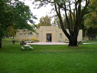
The Interpretive Center displays exhibits about the expedition, Native American tribes, and artifacts linked to the Wanapum and Umatilla peoples. The exhibits help visitors understand how this place connects to the people who have lived in the region for generations.

Practical

Vehicle access requires a Discover Pass, and the park operates from April through October for visitors. You can spend time hiking, boating, fishing, or participating in organized group activities during your visit.

Did you know?

Seven circular installations by a renowned artist are spread across the grounds, displaying information about local plants and animals. These artistic displays allow visitors to explore the natural surroundings in new ways.

Location
Inception
1931
GPS coordinates
46.20010,-119.04100
Latest update
December 11, 2025 18:06

AroundUs brings together thousands of curated places, local tips, and hidden gems, enriched daily by 60,000 contributors worldwide. Discover all places nearby (Franklin County).

Around this place
Pacific Northwest National Laboratory
United States of America

Pacific Northwest National Laboratory

24.1 km
Gold Coast Historic District
United States of America

Gold Coast Historic District

20.7 km
McNary Dam
United States of America

McNary Dam

35.5 km
Wallula Gap
United States of America

Wallula Gap

18.8 km
Ice Harbor Dam
United States of America

Ice Harbor Dam

13.6 km
Cable Bridge
United States of America

Cable Bridge

5.3 km
Fort Nez Percés
United States of America

Fort Nez Percés

16.4 km
Touchet Formation
United States of America

Touchet Formation

33.2 km
Blue Bridge
United States of America

Blue Bridge

7.8 km
Columbia River Washington Temple
United States of America

Columbia River Washington Temple

18.3 km
Juniper Dunes Wilderness
United States of America

Juniper Dunes Wilderness

25.6 km
Bateman Island
United States of America

Bateman Island

15.1 km
Hat Rock State Park
United States of America

Hat Rock State Park

33.2 km
Lake Wallula
United States of America

Lake Wallula

35.4 km
Umatilla Bridge
United States of America

Umatilla Bridge

37.6 km
Clover Island
United States of America

Clover Island

5.7 km
Cold Springs National Wildlife Refuge
United States of America

Cold Springs National Wildlife Refuge

38.4 km
Interstate 182 Bridge
United States of America

Interstate 182 Bridge

17.3 km
REACH Museum
United States of America

REACH Museum

14.1 km
Benton City – Kiona Bridge
United States of America

Benton City – Kiona Bridge

33.9 km
United States of America

Badger Mountain Centennial Preserve

21.7 km
Columbia River Exhibition of History, Science, and Technology
United States of America

Columbia River Exhibition of History, Science, and Technology

19.6 km
Clover Island Light
United States of America

Clover Island Light

5.7 km
Franklin County Courthouse
United States of America

Franklin County Courthouse

5.9 km
2800 Polar Way
United States of America

2800 Polar Way

25.3 km
USS Triton Submarine
United States of America

USS Triton Submarine

24.2 km
West Richland Golf Course
United States of America

West Richland Golf Course

25.5 km
Richland Theater
United States of America

Richland Theater

19.8 km
Show the full map
« Sacajawea State Park - State park in Franklin County, United States » is provided by Around Us (aroundus.com). Images and texts are derived from Wikimedia project under a Creative Commons license. You are allowed to copy, distribute, and modify copies of this page, under the conditions set by the license, as long as this note is clearly visible.

Discover hidden gems everywhere you go!

From secret cafés to breathtaking viewpoints, skip the crowded tourist spots and find places that match your style. Our app makes it easy with voice search, smart filtering, route optimization, and insider tips from travelers worldwide. Download now for the complete mobile experience.

Around Us App Screenshot

A unique approach to discovering new places

Le Figaro

All the places worth exploring

France Info

A tailor-made excursion in just a few clicks

20 Minutes

Around Us
Travel Guide & Maps
Download

Send to your phone

QR Code
1

Open the camera app on your mobile.

2

Point at the QR code with your camera. A notification will appear.

3

Tap the notification to open the link.