Juniper Dunes Wilderness

Log in to your account

AroundUs is a community-driven map of interesting places, built by curious explorers like you. It grows with every review, story, and photo you share.
Connect to save your favorite spots, contribute locations, and create personalized routes.
Continue with Google
Continue with Apple
Continue with X
Continue with Facebook
Continue with email
By continuing, you accept our Terms and Conditions and our Privacy Policy
Create an account

Juniper Dunes Wilderness

Add to collection
Map
Suggest a change
Share

Juniper Dunes Wilderness, Protected wilderness area in Franklin County, Washington.

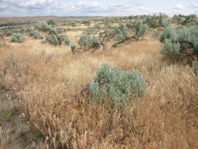
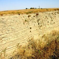
Juniper Dunes Wilderness is a protected area featuring sand dunes that rise up to 130 feet and roll across a dry landscape in eastern Washington. The terrain has sparse vegetation and relies on rainfall, with no permanent water sources throughout the expanse.

Congress established this wilderness area in 1984 to protect the northernmost natural growth of western juniper trees in North America. This action preserved the ecosystem in its original state.

The plants here, like rubber rabbitbrush and Indian ricegrass, are adapted to dry conditions and shape the landscape's appearance. Visitors notice these species as defining features of the high desert vegetation in eastern Washington.

Bring plenty of water as this area has no natural water sources and conditions are extremely dry. Anyone planning to camp overnight needs to obtain a permit from the land management office beforehand.

The area supports mule deer, bobcats, and porcupines living in one of the most isolated desert regions of the Northwest. These animals have adapted well to the extreme conditions and sparse plant life.

Location: Washington

Inception: 1984

GPS coordinates: 46.39170,-118.85600

Latest update: December 12, 2025 07:50

Photos
Around this place
Pacific Northwest National Laboratory
United States of America

Pacific Northwest National Laboratory

32.7 km
Gold Coast Historic District
United States of America

Gold Coast Historic District

33.5 km
Wallula Gap
United States of America

Wallula Gap

39.3 km
Ice Harbor Dam
United States of America

Ice Harbor Dam

15.9 km
Cable Bridge
United States of America

Cable Bridge

27.1 km
Fort Nez Percés
United States of America

Fort Nez Percés

34.5 km
Columbia Plateau State Park Trail
United States of America

Columbia Plateau State Park Trail

36.4 km
Touchet Formation
United States of America

Touchet Formation

42.1 km
Blue Bridge
United States of America

Blue Bridge

28.4 km
Abraham Lincoln
United States of America

Abraham Lincoln

51.9 km
Columbia River Washington Temple
United States of America

Columbia River Washington Temple

37.1 km
Sacajawea State Park
United States of America

Sacajawea State Park

25.6 km
Bateman Island
United States of America

Bateman Island

32.8 km
Lower Monumental Dam
United States of America

Lower Monumental Dam

31 km
Clover Island
United States of America

Clover Island

27.6 km
Interstate 182 Bridge
United States of America

Interstate 182 Bridge

33.2 km
REACH Museum
United States of America

REACH Museum

32.7 km
Benton City – Kiona Bridge
United States of America

Benton City – Kiona Bridge

50 km
United States of America

Badger Mountain Centennial Preserve

39.6 km
Columbia River Exhibition of History, Science, and Technology
United States of America

Columbia River Exhibition of History, Science, and Technology

34.6 km
Clover Island Light
United States of America

Clover Island Light

27.6 km
Walla Walla Valley Traction Company Car Barn
United States of America

Walla Walla Valley Traction Company Car Barn

52.7 km
Franklin County Courthouse
United States of America

Franklin County Courthouse

25.2 km
2800 Polar Way
United States of America

2800 Polar Way

35 km
USS Triton Submarine
United States of America

USS Triton Submarine

32.1 km
West Richland Golf Course
United States of America

West Richland Golf Course

38.2 km
Richland Theater
United States of America

Richland Theater

34.7 km
Keewaydin Park
United States of America

Keewaydin Park

29.1 km
Show the full map
Reviews

Visited this place? Tap the stars to rate it and share your experience / photos with the community! Try now! You can cancel it anytime.

« Juniper Dunes Wilderness - Protected wilderness area in Franklin County, Washington » is provided by Around Us (aroundus.com). Images and texts are derived from Wikimedia project under a Creative Commons license. You are allowed to copy, distribute, and modify copies of this page, under the conditions set by the license, as long as this note is clearly visible.

Discover hidden gems everywhere you go!

From secret cafés to breathtaking viewpoints, skip the crowded tourist spots and find places that match your style. Our app makes it easy with voice search, smart filtering, route optimization, and insider tips from travelers worldwide. Download now for the complete mobile experience.

Around Us App Screenshot

A unique approach to discovering new places

Le Figaro

All the places worth exploring

France Info

A tailor-made excursion in just a few clicks

20 Minutes