Enable Location

We need your location to show you interesting places around you

Discover nearby places

Find interesting locations and hidden gems around you

Precise directions

Get accurate directions and distances to places

Your location is never shared with other users. It's only used when you tap the location button.

Ice Harbor Dam

Log in to your account

Start exploring — it's free

Trusted by 62,889 travelers worldwide

Continue with Google
Continue with Apple
or

We will send you a code to connect

By continuing, you accept our Terms and Conditions and our Privacy Policy

Check your inbox

We've sent a pincode in your inbox. Please enter the code below.

Discussion Reviews 1 Photos
7.8k Popularity

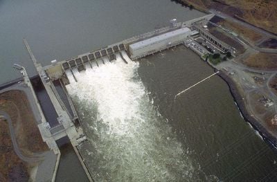
Ice Harbor Dam, Hydroelectric gravity dam in Walla Walla County, US.

Ice Harbor Dam is a gravity structure spanning approximately 860 meters across the Snake River and generating electricity through six turbines. The facility regulates water levels for river navigation and features a fish ladder system visible to visitors from designated viewing areas.

Construction by the U.S. Army Corps of Engineers started in 1956 with the main structure completed in 1961. Additional generator units were installed in subsequent years to expand power generation capacity.

The name references a small bay where vessels once waited during winter for upstream ice to break up. Today this historical name reflects the river's importance to the region's commerce and navigation heritage.

A visitor center on the south bank offers exhibits about facility operations and allows viewing of migrating fish. Visit during fish migration season for the most active observation of fish passing through the ladder system.

The region recorded extreme heat of about 118°F in 1961, revealing how harsh the climate can be in this area. Such temperature extremes define the region's character and make it one of the hottest places in Washington state.

The community of curious travelers

AroundUs brings together thousands of curated places, local tips, and hidden gems, enriched daily by 60,000 contributors worldwide.

Start exploring
Inception
1956
Length
860 m
GPS coordinates
46.24960,-118.88000
Latest update
December 8, 2025 20:00
Around this place
Pacific Northwest National Laboratory
United States of America

Pacific Northwest National Laboratory

32.2 km
Gold Coast Historic District
United States of America

Gold Coast Historic District

30.5 km
Wallula Gap
United States of America

Wallula Gap

23.4 km
Cable Bridge
United States of America

Cable Bridge

17.6 km
Fort Nez Percés
United States of America

Fort Nez Percés

18.5 km
Touchet Formation
United States of America

Touchet Formation

28.5 km
Blue Bridge
United States of America

Blue Bridge

19.9 km
Columbia River Washington Temple
United States of America

Columbia River Washington Temple

30.5 km
Sacajawea State Park
United States of America

Sacajawea State Park

13.6 km
Juniper Dunes Wilderness
United States of America

Juniper Dunes Wilderness

15.9 km
Bateman Island
United States of America

Bateman Island

26.6 km
Hat Rock State Park
United States of America

Hat Rock State Park

43.3 km
Lower Monumental Dam
United States of America

Lower Monumental Dam

43.7 km
Clover Island
United States of America

Clover Island

18.2 km
Interstate 182 Bridge
United States of America

Interstate 182 Bridge

28.2 km
REACH Museum
United States of America

REACH Museum

26 km
Benton City – Kiona Bridge
United States of America

Benton City – Kiona Bridge

45.8 km
United States of America

Badger Mountain Centennial Preserve

33.8 km
Columbia River Exhibition of History, Science, and Technology
United States of America

Columbia River Exhibition of History, Science, and Technology

30.3 km
Electric Light Works Building
United States of America

Electric Light Works Building

46 km
Clover Island Light
United States of America

Clover Island Light

18.2 km
Walla Walla Valley Traction Company Car Barn
United States of America

Walla Walla Valley Traction Company Car Barn

45.1 km
Franklin County Courthouse
United States of America

Franklin County Courthouse

16.7 km
2800 Polar Way
United States of America

2800 Polar Way

34 km
USS Triton Submarine
United States of America

USS Triton Submarine

31.9 km
Children's Museum of Walla Walla
United States of America

Children's Museum of Walla Walla

45.6 km
West Richland Golf Course
United States of America

West Richland Golf Course

35.6 km
Richland Theater
United States of America

Richland Theater

30.5 km
Show the full map
« Ice Harbor Dam - Hydroelectric gravity dam in Walla Walla County, US » is provided by Around Us (aroundus.com). Images and texts are derived from Wikimedia project under a Creative Commons license. You are allowed to copy, distribute, and modify copies of this page, under the conditions set by the license, as long as this note is clearly visible.

Discover hidden gems everywhere you go!

From secret cafés to breathtaking viewpoints, skip the crowded tourist spots and find places that match your style. Our app makes it easy with voice search, smart filtering, route optimization, and insider tips from travelers worldwide. Download now for the complete mobile experience.

Around Us App Screenshot

A unique approach to discovering new places

Le Figaro

All the places worth exploring

France Info

A tailor-made excursion in just a few clicks

20 Minutes

Around Us
Travel Guide & Maps
Download

Send to your phone

QR Code
1

Open the camera app on your mobile.

2

Point at the QR code with your camera. A notification will appear.

3

Tap the notification to open the link.