Enable Location

We need your location to show you interesting places around you

Discover nearby places

Find interesting locations and hidden gems around you

Precise directions

Get accurate directions and distances to places

Your location is never shared with other users. It's only used when you tap the location button.

Fort Nez Percés

Log in to your account

Start exploring — it's free

Trusted by 62,889 travelers worldwide

Continue with Google
Continue with Apple
or

We will send you a code to connect

By continuing, you accept our Terms and Conditions and our Privacy Policy

Check your inbox

We've sent a pincode in your inbox. Please enter the code below.

Fort Nez Percés
Discussion Reviews 1 Photos
7.3k Popularity

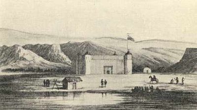
Fort Nez Percés, Trading fort on Columbia River at Wallula, United States.

Fort Nez Percés is a trading post on the Columbia River at Wallula with double wooden palisades and defensive towers at each corner. The structure included water storage and cannons, functioning as a supply stop for travelers and fur traders moving through the region.

The North West Company built the fort in 1818 as a strategic trading post, which came under Hudson's Bay Company control in 1821. This transfer shifted management of the site and how it operated for decades to come.

The fort brought together European traders and local nations including the Umatilla, Cayuse, Nez Perce, and Walla Walla who exchanged goods and information. These interactions shaped how commerce and relationships developed across the region.

The site sits about six miles from where the Snake River meets the Columbia, making it a useful stop for people traveling the Oregon Trail. The location provided easy access to water and supplies for those passing through the region.

After burning in 1841, the fort was rebuilt using adobe bricks instead of wood, marking a shift in construction methods for the region. This change reflected how building techniques adapted to local conditions and available materials.

The community of curious travelers

AroundUs brings together thousands of curated places, local tips, and hidden gems, enriched daily by 60,000 contributors worldwide.

Start exploring
Location
GPS coordinates
46.08420,-118.90900
Latest update
December 8, 2025 20:03
Around this place
Pacific Northwest National Laboratory
United States of America

Pacific Northwest National Laboratory

40.4 km
Gold Coast Historic District
United States of America

Gold Coast Historic District

36.6 km
McNary Dam
United States of America

McNary Dam

34.3 km
Wallula Gap
United States of America

Wallula Gap

5.3 km
Ice Harbor Dam
United States of America

Ice Harbor Dam

18.5 km
Cable Bridge
United States of America

Cable Bridge

21.2 km
Touchet Formation
United States of America

Touchet Formation

18.3 km
Blue Bridge
United States of America

Blue Bridge

23.5 km
Columbia River Washington Temple
United States of America

Columbia River Washington Temple

32.4 km
Sacajawea State Park
United States of America

Sacajawea State Park

16.4 km
Juniper Dunes Wilderness
United States of America

Juniper Dunes Wilderness

34.5 km
Bateman Island
United States of America

Bateman Island

30.3 km
Hat Rock State Park
United States of America

Hat Rock State Park

27.3 km
Lake Wallula
United States of America

Lake Wallula

34.3 km
Umatilla Bridge
United States of America

Umatilla Bridge

36.7 km
Clover Island
United States of America

Clover Island

21.5 km
Cold Springs National Wildlife Refuge
United States of America

Cold Springs National Wildlife Refuge

30.8 km
Interstate 182 Bridge
United States of America

Interstate 182 Bridge

32.8 km
REACH Museum
United States of America

REACH Museum

29.1 km
United States of America

Badger Mountain Centennial Preserve

35.7 km
Columbia River Exhibition of History, Science, and Technology
United States of America

Columbia River Exhibition of History, Science, and Technology

35 km
Greasewood Finnish Apostolic Lutheran Church
United States of America

Greasewood Finnish Apostolic Lutheran Church

39.3 km
Clover Island Light
United States of America

Clover Island Light

21.5 km
Franklin County Courthouse
United States of America

Franklin County Courthouse

22.3 km
2800 Polar Way
United States of America

2800 Polar Way

41.4 km
USS Triton Submarine
United States of America

USS Triton Submarine

40.5 km
West Richland Golf Course
United States of America

West Richland Golf Course

41 km
Richland Theater
United States of America

Richland Theater

35.2 km
Show the full map
« Fort Nez Percés - Trading fort on Columbia River at Wallula, United States » is provided by Around Us (aroundus.com). Images and texts are derived from Wikimedia project under a Creative Commons license. You are allowed to copy, distribute, and modify copies of this page, under the conditions set by the license, as long as this note is clearly visible.

Discover hidden gems everywhere you go!

From secret cafés to breathtaking viewpoints, skip the crowded tourist spots and find places that match your style. Our app makes it easy with voice search, smart filtering, route optimization, and insider tips from travelers worldwide. Download now for the complete mobile experience.

Around Us App Screenshot

A unique approach to discovering new places

Le Figaro

All the places worth exploring

France Info

A tailor-made excursion in just a few clicks

20 Minutes

Around Us
Travel Guide & Maps
Download

Send to your phone

QR Code
1

Open the camera app on your mobile.

2

Point at the QR code with your camera. A notification will appear.

3

Tap the notification to open the link.