Enable Location

We need your location to show you interesting places around you

Discover nearby places

Find interesting locations and hidden gems around you

Precise directions

Get accurate directions and distances to places

Your location is never shared with other users. It's only used when you tap the location button.

McNary Dam

Log in to your account

Start exploring — it's free

Trusted by 61,820 travelers worldwide

Continue with Google
Continue with Apple
or

We will send you a code to connect

By continuing, you accept our Terms and Conditions and our Privacy Policy

Check your inbox

We've sent a pincode in your inbox. Please enter the code below.

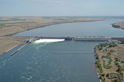
McNary Dam, Hydroelectric power station and dam on Columbia River, Oregon and Washington, United States

Description

McNary Dam is a hydroelectric installation spanning 2245 meters across the Columbia River between Oregon and Washington. The structure harnesses the river's flow to generate power for the region.

History

Construction started in 1947 under the U.S. Army Corps of Engineers and progressed through the mid-1950s. The project was part of a larger effort to develop hydropower along the Columbia River system.

Culture

The structure received its name in honor of Senator Charles L. McNary of Oregon through the Flood Control Act of 1945.

Practical

The installation includes fish passage facilities for salmon migration and a lock system for river navigation. Visitors can observe the infrastructure from several viewpoints around the site.

Did you know?

The dam can rapidly restore power to the grid following major electrical failures, making it a critical safety resource. This capability allows it to help stabilize regional electricity supply during emergencies.

Location
Location
Inception
1947
Length
2,245 m
GPS coordinates
45.93556,-119.29806
Latest update
December 8, 2025 19:55

AroundUs brings together thousands of curated places, local tips, and hidden gems, enriched daily by 60,000 contributors worldwide. Discover all places nearby (Umatilla County).

Around this place
Gold Coast Historic District
United States of America

Gold Coast Historic District

40.4 km
Wallula Gap
United States of America

Wallula Gap

29.7 km
Cable Bridge
United States of America

Cable Bridge

34.9 km
Fort Nez Percés
United States of America

Fort Nez Percés

34.3 km
Blue Bridge
United States of America

Blue Bridge

34.6 km
Columbia River Washington Temple
United States of America

Columbia River Washington Temple

32.5 km
Sacajawea State Park
United States of America

Sacajawea State Park

35.5 km
Bateman Island
United States of America

Bateman Island

34.9 km
Hat Rock State Park
United States of America

Hat Rock State Park

10.6 km
Lake Wallula
United States of America

Lake Wallula

95 m
Umatilla Bridge
United States of America

Umatilla Bridge

2.4 km
Clover Island
United States of America

Clover Island

34.5 km
Umatilla National Wildlife Refuge
United States of America

Umatilla National Wildlife Refuge

23.8 km
Cold Springs National Wildlife Refuge
United States of America

Cold Springs National Wildlife Refuge

14 km
Interstate 182 Bridge
United States of America

Interstate 182 Bridge

36.8 km
REACH Museum
United States of America

REACH Museum

34 km
Benton City – Kiona Bridge
United States of America

Benton City – Kiona Bridge

37.9 km
United States of America

Badger Mountain Centennial Preserve

33.4 km
Columbia River Exhibition of History, Science, and Technology
United States of America

Columbia River Exhibition of History, Science, and Technology

37.7 km
St. Peter's Roman Catholic Church
United States of America

St. Peter's Roman Catholic Church

23.1 km
Echo Methodist Church
United States of America

Echo Methodist Church

22.9 km
James H. and Cynthia Koontz House
United States of America

James H. and Cynthia Koontz House

22.7 km
Bank of Echo Building
United States of America

Bank of Echo Building

23 km
Clover Island Light
United States of America

Clover Island Light

34.5 km
Echo City Hall
United States of America

Echo City Hall

23 km
Franklin County Courthouse
United States of America

Franklin County Courthouse

37 km
West Richland Golf Course
United States of America

West Richland Golf Course

41.2 km
Richland Theater
United States of America

Richland Theater

37.8 km
Show the full map
« McNary Dam - Hydroelectric power station and dam on Columbia River, Oregon and Washington, United States » is provided by Around Us (aroundus.com). Images and texts are derived from Wikimedia project under a Creative Commons license. You are allowed to copy, distribute, and modify copies of this page, under the conditions set by the license, as long as this note is clearly visible.

Discover hidden gems everywhere you go!

From secret cafés to breathtaking viewpoints, skip the crowded tourist spots and find places that match your style. Our app makes it easy with voice search, smart filtering, route optimization, and insider tips from travelers worldwide. Download now for the complete mobile experience.

Around Us App Screenshot

A unique approach to discovering new places

Le Figaro

All the places worth exploring

France Info

A tailor-made excursion in just a few clicks

20 Minutes

Around Us
Travel Guide & Maps
Download

Send to your phone

QR Code
1

Open the camera app on your mobile.

2

Point at the QR code with your camera. A notification will appear.

3

Tap the notification to open the link.