Rattlesnake Mountain, Mountain summit in Benton County, Washington, US
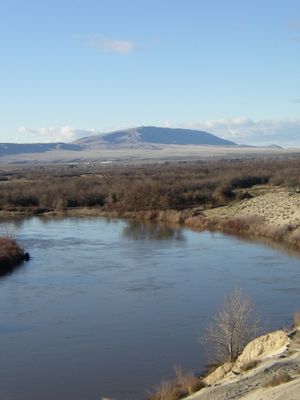
Rattlesnake Mountain is a bare ridge in Benton County that rises to approximately 3,531 feet above sea level and stretches across the landscape. The slopes are steep and treeless, creating open terrain that stands out from the surrounding area.
The mountain stood partially above water during the ancient Missoula Floods, which submerged much of the Columbia River Plateau thousands of years ago. These geological events shaped the landscape that surrounds the peak today.
Local tribes including the Yakama Nation call this peak Lalíik, meaning 'land above the water' in their language. The name reflects how the tribes understood this landmark in relation to the water systems around it.
Access to the mountain summit is restricted by the Department of Energy and requires special permits obtained in advance. Visitors should check current access regulations and arrange permits before attempting to reach the peak.
Wind speeds at this peak reach extreme levels, with recorded gusts exceeding 150 miles per hour (240 kilometers per hour) at the exposed summit. These powerful winds make the ridge one of the windiest locations in the region.
The community of curious travelers
AroundUs brings together thousands of curated places, local tips, and hidden gems, enriched daily by 60,000 contributors worldwide.