Columbia National Wildlife Refuge

Log in to your account

AroundUs is a community-driven map of interesting places, built by curious explorers like you. It grows with every review, story, and photo you share.
Connect to save your favorite spots, contribute locations, and create personalized routes.
Continue with Google
Continue with Apple
Continue with X
Continue with Facebook
Continue with email
By continuing, you accept our Terms and Conditions and our Privacy Policy
Create an account

Columbia National Wildlife Refuge

Add to collection
Map
Suggest a change
Share

Columbia National Wildlife Refuge, Wildlife refuge in central Washington, United States.

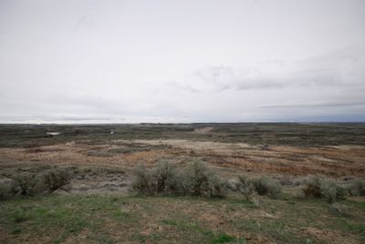
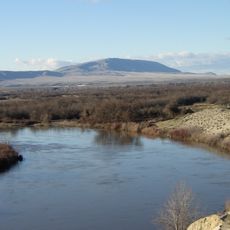
The Columbia National Wildlife Refuge spans roughly 30,000 acres with cliffs, canyons, lakes, and sagebrush grasslands in the Drumheller Channeled Scablands of central Washington. The terrain shows a striking landscape with waterways, plateaus, and open spaces that can be explored on foot or by car.

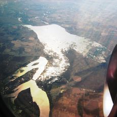
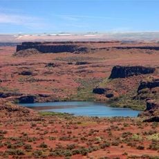
The refuge was established in 1944 as part of the Columbia Basin Project, which transformed the region through irrigation development. The reservoirs and water sources that fill the landscape today stem from this major infrastructure effort that reshaped the area.

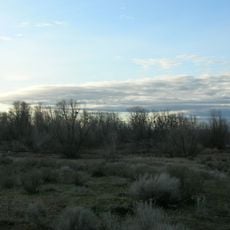
This protected land is essential for thousands of migratory birds that pass through during spring and fall journeys. The refuge offers visitors chances to see waterfowl, raptors, and other species in their natural setting as they move along ancient migration routes.

Access is available through McManamon Road from Othello, where parking areas and information maps guide exploration of trails and lakes. Visitors should allow time to explore multiple sites and watch for changing weather, as the open terrain offers little shelter.

The Drumheller Channels section displays one of the most extensively eroded landscapes of its size worldwide, earning National Natural Landmark designation in 1986. Visitors can explore this rare geological formation shaped by massive water movement thousands of years ago.

Location: Washington

Website: https://fws.gov/refuge/columbia

GPS coordinates: 46.85120,-119.53700

Latest update: December 11, 2025 18:04

Photos
Around this place
The Gorge Amphitheatre
United States of America

The Gorge Amphitheatre

44.5 km
Pacific Northwest National Laboratory
United States of America

Pacific Northwest National Laboratory

60 km
B Reactor
United States of America

B Reactor

26 km
Ginkgo Petrified Forest State Park
United States of America

Ginkgo Petrified Forest State Park

37.1 km
Moses Lake
United States of America

Moses Lake

35 km
Iron Horse State Park
United States of America

Iron Horse State Park

50.4 km
Rattlesnake Mountain
United States of America

Rattlesnake Mountain

49.8 km
Grandfather Cuts Loose the Ponies
United States of America

Grandfather Cuts Loose the Ponies

34.7 km
Potholes State Park
United States of America

Potholes State Park

20.1 km
Wanapum Dam
United States of America

Wanapum Dam

33.1 km
Potholes Reservoir
United States of America

Potholes Reservoir

23.7 km
Priest Rapids Dam
United States of America

Priest Rapids Dam

36.6 km
Wild Horse Wind and Solar Facility
United States of America

Wild Horse Wind and Solar Facility

54.9 km
Drumheller Channels National Natural Landmark
United States of America

Drumheller Channels National Natural Landmark

29.4 km
Whiskey Dick Mountain
United States of America

Whiskey Dick Mountain

56.3 km
Abraham Lincoln
United States of America

Abraham Lincoln

37.1 km
Vantage Bridge
United States of America

Vantage Bridge

34.3 km
Beverly Railroad Bridge
United States of America

Beverly Railroad Bridge

31.4 km
Priest Rapids
United States of America

Priest Rapids

34.8 km
Vernita Bridge
United States of America

Vernita Bridge

27.6 km
Wanapum Lake
United States of America

Wanapum Lake

33.2 km
Canada

Sentinel Gap

30.7 km
Grant County Courthouse
United States of America

Grant County Courthouse

52.4 km
Grant County Fairgrounds
United States of America

Grant County Fairgrounds

36.8 km
2800 Polar Way
United States of America

2800 Polar Way

60.1 km
USS Triton Submarine
United States of America

USS Triton Submarine

59.6 km
Moses Lake Museum & Art Center
United States of America

Moses Lake Museum & Art Center

37 km
West Richland Golf Course
United States of America

West Richland Golf Course

62.8 km
Show the full map
Reviews

Visited this place? Tap the stars to rate it and share your experience / photos with the community! Try now! You can cancel it anytime.

« Columbia National Wildlife Refuge - Wildlife refuge in central Washington, United States » is provided by Around Us (aroundus.com). Images and texts are derived from Wikimedia project under a Creative Commons license. You are allowed to copy, distribute, and modify copies of this page, under the conditions set by the license, as long as this note is clearly visible.

Discover hidden gems everywhere you go!

From secret cafés to breathtaking viewpoints, skip the crowded tourist spots and find places that match your style. Our app makes it easy with voice search, smart filtering, route optimization, and insider tips from travelers worldwide. Download now for the complete mobile experience.

Around Us App Screenshot

A unique approach to discovering new places

Le Figaro

All the places worth exploring

France Info

A tailor-made excursion in just a few clicks

20 Minutes