Enable Location

We need your location to show you interesting places around you

Discover nearby places

Find interesting locations and hidden gems around you

Precise directions

Get accurate directions and distances to places

Your location is never shared with other users. It's only used when you tap the location button.

Wanapum Dam

Log in to your account

Start exploring — it's free

Trusted by 61,533 travelers worldwide

Continue with Google
Continue with Apple
or

We will send you a code to connect

By continuing, you accept our Terms and Conditions and our Privacy Policy

Check your inbox

We've sent a pincode in your inbox. Please enter the code below.

Wanapum Dam, Hydroelectric power station in Grant County, United States
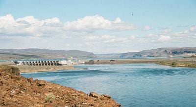
Description

Wanapum Dam is an embankment dam spanning roughly 2.6 kilometers across the Columbia River that generates electricity through ten turbine units. The facility operates as a gravity dam, using water pressure to produce power continuously.

History

Construction began in 1959, and the facility started operating in 1963 without requiring government funding or tax support. The project was developed by a local utility company as a self-financed infrastructure initiative.

Culture

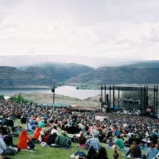
The dam takes its name from the Wanapum people, who have inhabited this stretch of the Columbia River for generations and maintain a living community nearby. Their presence shapes how the place is understood as more than just an engineering project.

Practical

A visitor center at the site provides educational displays and films about hydroelectric power generation. It is a good place to learn about the technical basics of the operation and observe the scale of the facility from different viewpoints.

Did you know?

In 2014, engineers discovered a small crack in the spillway that was traced back to a mathematical error in the original design. The subsequent inspection lasting several weeks revealed important findings about the structure's durability and safety.

Location
Inception
1959
Elevation above the sea
174 m
Length
2,632 m
GPS coordinates
46.87520,-119.97100
Latest update
December 9, 2025 18:42

AroundUs brings together thousands of curated places, local tips, and hidden gems, enriched daily by 60,000 contributors worldwide. Discover all places nearby (Grant County).

Around this place
The Gorge Amphitheatre
United States of America

The Gorge Amphitheatre

25.2 km
B Reactor
United States of America

B Reactor

36.8 km
Ginkgo Petrified Forest State Park
United States of America

Ginkgo Petrified Forest State Park

8.6 km
Iron Horse State Park
United States of America

Iron Horse State Park

17.3 km
Yakima SunDome
United States of America

Yakima SunDome

50.6 km
Grandfather Cuts Loose the Ponies
United States of America

Grandfather Cuts Loose the Ponies

10.1 km
Potholes State Park
United States of America

Potholes State Park

48.6 km
Priest Rapids Dam
United States of America

Priest Rapids Dam

26.3 km
Wild Horse Wind and Solar Facility
United States of America

Wild Horse Wind and Solar Facility

24.5 km
Whiskey Dick Mountain
United States of America

Whiskey Dick Mountain

25.9 km
Vantage Bridge
United States of America

Vantage Bridge

7.6 km
Fred G. Redmon Bridge
United States of America

Fred G. Redmon Bridge

40.8 km
Columbia National Wildlife Refuge
United States of America

Columbia National Wildlife Refuge

33.1 km
Olmstead Place State Park
United States of America

Olmstead Place State Park

39.5 km
Beverly Railroad Bridge
United States of America

Beverly Railroad Bridge

5.2 km
Priest Rapids
United States of America

Priest Rapids

13.4 km
Capitol Theatre, Yakima
United States of America

Capitol Theatre, Yakima

50.6 km
Vernita Bridge
United States of America

Vernita Bridge

31.6 km
A. E. Larson Building
United States of America

A. E. Larson Building

50.8 km
William O. Douglas Federal Building
United States of America

William O. Douglas Federal Building

50.6 km
Umtanum Ridge Water Gap
United States of America

Umtanum Ridge Water Gap

43.7 km
Wanapum Lake
United States of America

Wanapum Lake

246 m
Central Washington State Fair
United States of America

Central Washington State Fair

50.4 km
Masonic Temple
United States of America

Masonic Temple

50.5 km
Canada

Sentinel Gap

8.3 km
Powell House
United States of America

Powell House

50.1 km
Water Playground
United States of America

Water Playground

50.4 km
Naches River Railroad Bridge
United States of America

Naches River Railroad Bridge

50.1 km
Show the full map
« Wanapum Dam - Hydroelectric power station in Grant County, United States » is provided by Around Us (aroundus.com). Images and texts are derived from Wikimedia project under a Creative Commons license. You are allowed to copy, distribute, and modify copies of this page, under the conditions set by the license, as long as this note is clearly visible.

Discover hidden gems everywhere you go!

From secret cafés to breathtaking viewpoints, skip the crowded tourist spots and find places that match your style. Our app makes it easy with voice search, smart filtering, route optimization, and insider tips from travelers worldwide. Download now for the complete mobile experience.

Around Us App Screenshot

A unique approach to discovering new places

Le Figaro

All the places worth exploring

France Info

A tailor-made excursion in just a few clicks

20 Minutes

Around Us
Travel Guide & Maps
Download

Send to your phone

QR Code
1

Open the camera app on your mobile.

2

Point at the QR code with your camera. A notification will appear.

3

Tap the notification to open the link.