Enable Location

We need your location to show you interesting places around you

Discover nearby places

Find interesting locations and hidden gems around you

Precise directions

Get accurate directions and distances to places

Your location is never shared with other users. It's only used when you tap the location button.

Wanapum Lake

Log in to your account

Start exploring — it's free

Trusted by 62,339 travelers worldwide

Continue with Google
Continue with Apple
or

We will send you a code to connect

By continuing, you accept our Terms and Conditions and our Privacy Policy

Check your inbox

We've sent a pincode in your inbox. Please enter the code below.

Wanapum Lake

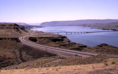
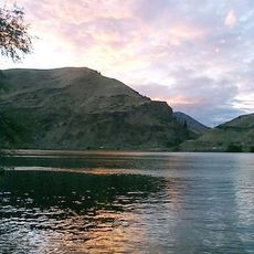
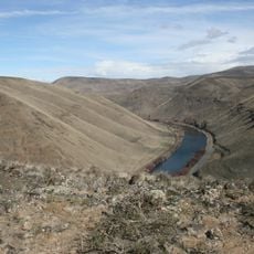
Wanapum Lake, reservoir on the Columbia River in central Washington state, United States of America

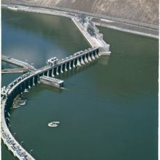
Wanapum Lake is a large reservoir in Washington spanning four counties and created by the Wanapum Dam holding back water from the Columbia River. The water stretches between Wanapum Dam downstream and Rock Island Dam upstream, covering over 1000 acres of surface area.

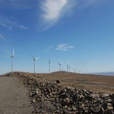
The lake was formed in 1963 when Wanapum Dam was completed to store water and generate electricity for the region. This project was part of a larger effort to manage the Columbia River and provide power to nearby towns and farms.

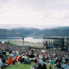
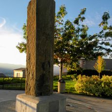
The lake is named after the Wanapum people, an indigenous nation that has long inhabited this region. Today, trails and sites near the water honor this heritage and help visitors learn about the local history and the land's significance to earlier generations.

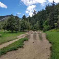
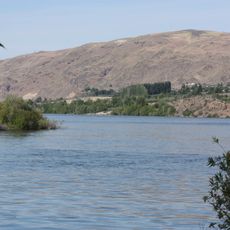
The lake is accessible from multiple locations with boat ramps and parking areas, while shore trails offer easy walks for visitors of all abilities. Plan to visit early morning or evening for the best fishing conditions and the calmest water.

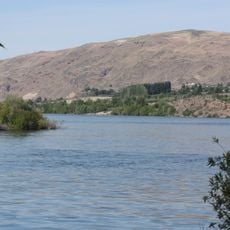
The lake receives constant water flow from the Columbia River, which keeps it fresh and active even during dry months, unlike lakes that sit still and stagnate. This continuous movement is why the water stays suitable for boating, fishing, and swimming throughout the year.

The community of curious travelers

AroundUs brings together thousands of curated places, local tips, and hidden gems, enriched daily by 60,000 contributors worldwide.

Start exploring
Location
Location
Location
Location
Location
Elevation above the sea
174 m
GPS coordinates
46.87310,-119.97200
Latest update
February 9, 2026 08:19
Around this place
The Gorge Amphitheatre
United States of America

The Gorge Amphitheatre

25.4 km
Ginkgo Petrified Forest State Park
United States of America

Ginkgo Petrified Forest State Park

8.8 km
Iron Horse State Park
United States of America

Iron Horse State Park

17.3 km
Grandfather Cuts Loose the Ponies
United States of America

Grandfather Cuts Loose the Ponies

10.4 km
Wanapum Dam
United States of America

Wanapum Dam

246 m
Wild Horse Wind and Solar Facility
United States of America

Wild Horse Wind and Solar Facility

24.6 km
Rock Island Dam
United States of America

Rock Island Dam

53 km
Lincoln Rock State Park
United States of America

Lincoln Rock State Park

74.8 km
Whiskey Dick Mountain
United States of America

Whiskey Dick Mountain

26 km
Vantage Bridge
United States of America

Vantage Bridge

7.9 km
Columbia National Wildlife Refuge
United States of America

Columbia National Wildlife Refuge

33.2 km
Columbia River Bridge
United States of America

Columbia River Bridge

65.1 km
Olmstead Place State Park
United States of America

Olmstead Place State Park

39.5 km
Wenatchee Confluence State Park
United States of America

Wenatchee Confluence State Park

70.5 km
Beverly Railroad Bridge
United States of America

Beverly Railroad Bridge

5 km
Priest Rapids
United States of America

Priest Rapids

13.2 km
Squilchuck State Park
United States of America

Squilchuck State Park

57.4 km
Senator George Sellar Bridge
United States of America

Senator George Sellar Bridge

64.6 km
Wenatchee Valley Museum & Cultural Center
United States of America

Wenatchee Valley Museum & Cultural Center

66.3 km
Rock Island Railroad Bridge
United States of America

Rock Island Railroad Bridge

56.7 km
Richard Odabashian Bridge
United States of America

Richard Odabashian Bridge

71.5 km
Umtanum Ridge Water Gap
United States of America

Umtanum Ridge Water Gap

43.6 km
Downtown Wenatchee Historic District
United States of America

Downtown Wenatchee Historic District

66.4 km
Canada

Sentinel Gap

8.1 km
Pangborn-Herndon Memorial Site
United States of America

Pangborn-Herndon Memorial Site

67.6 km
Grant County Courthouse
United States of America

Grant County Courthouse

59.2 km
Liberty Theatre
United States of America

Liberty Theatre

66.5 km
Rock Island Pool
United States of America

Rock Island Pool

53.1 km
Show the full map
« Wanapum Lake - reservoir on the Columbia River in central Washington state, United States of America » is provided by Around Us (aroundus.com). Images and texts are derived from Wikimedia project under a Creative Commons license. You are allowed to copy, distribute, and modify copies of this page, under the conditions set by the license, as long as this note is clearly visible.

Discover hidden gems everywhere you go!

From secret cafés to breathtaking viewpoints, skip the crowded tourist spots and find places that match your style. Our app makes it easy with voice search, smart filtering, route optimization, and insider tips from travelers worldwide. Download now for the complete mobile experience.

Around Us App Screenshot

A unique approach to discovering new places

Le Figaro

All the places worth exploring

France Info

A tailor-made excursion in just a few clicks

20 Minutes

Around Us
Travel Guide & Maps
Download

Send to your phone

QR Code
1

Open the camera app on your mobile.

2

Point at the QR code with your camera. A notification will appear.

3

Tap the notification to open the link.