Enable Location

We need your location to show you interesting places around you

Discover nearby places

Find interesting locations and hidden gems around you

Precise directions

Get accurate directions and distances to places

Your location is never shared with other users. It's only used when you tap the location button.

Wild Horse Wind and Solar Facility

Log in to your account

Start exploring — it's free

Trusted by 62,341 travelers worldwide

Continue with Google
Continue with Apple
or

We will send you a code to connect

By continuing, you accept our Terms and Conditions and our Privacy Policy

Check your inbox

We've sent a pincode in your inbox. Please enter the code below.

Wild Horse Wind and Solar Facility

Wild Horse Wind and Solar Facility, Wind and solar power facility in Kittitas County, United States.

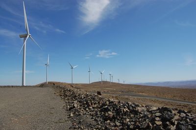
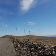
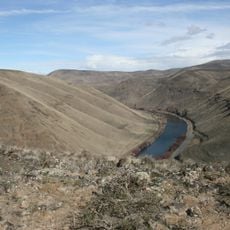
Wild Horse Wind and Solar Facility is a large energy complex on open range land in central Washington situated at about 1036 meters elevation. The site spans 10000 acres and combines 149 wind turbines with solar installations to generate electricity.

The facility began operations in December 2006, marking the start of power generation at this location. An expansion followed in 2009 that added more turbines and significantly increased the complex's capacity.

The Renewable Energy Center provides educational programs about power generation through guided tours, internships, and interactive displays explaining wind and solar technologies.

Visitors can explore the grounds on their own or join guided tours available from April through October. The open terrain requires appropriate clothing and preparation for weather conditions at elevation.

Each wind turbine rises about 107 meters high and features blades about 39 meters long, generating electricity at wind speeds between 14 and 90 kilometers per hour. These heights allow the turbines to capture stronger winds and operate more efficiently.

The community of curious travelers

AroundUs brings together thousands of curated places, local tips, and hidden gems, enriched daily by 60,000 contributors worldwide.

Start exploring
Location
Location
Inception
December 2006
Elevation above the sea
1,036 m
Operator
Puget Sound Energy
GPS coordinates
47.01850,-120.21600
Latest update
December 9, 2025 18:44
Around this place
The Gorge Amphitheatre
United States of America

The Gorge Amphitheatre

19.1 km
Ginkgo Petrified Forest State Park
United States of America

Ginkgo Petrified Forest State Park

17.9 km
Iron Horse State Park
United States of America

Iron Horse State Park

12.7 km
Grandfather Cuts Loose the Ponies
United States of America

Grandfather Cuts Loose the Ponies

20.2 km
Wanapum Dam
United States of America

Wanapum Dam

24.5 km
Priest Rapids Dam
United States of America

Priest Rapids Dam

47.9 km
Rock Island Dam
United States of America

Rock Island Dam

37.2 km
Whiskey Dick Mountain
United States of America

Whiskey Dick Mountain

1.4 km
Vantage Bridge
United States of America

Vantage Bridge

20.7 km
Fred G. Redmon Bridge
United States of America

Fred G. Redmon Bridge

39.4 km
Columbia River Bridge
United States of America

Columbia River Bridge

44.5 km
Olmstead Place State Park
United States of America

Olmstead Place State Park

20.2 km
Wenatchee Confluence State Park
United States of America

Wenatchee Confluence State Park

49.7 km
Beverly Railroad Bridge
United States of America

Beverly Railroad Bridge

29.2 km
Priest Rapids
United States of America

Priest Rapids

34.7 km
Squilchuck State Park
United States of America

Squilchuck State Park

34.6 km
Senator George Sellar Bridge
United States of America

Senator George Sellar Bridge

44 km
Wenatchee Valley Museum & Cultural Center
United States of America

Wenatchee Valley Museum & Cultural Center

45.5 km
Rock Island Railroad Bridge
United States of America

Rock Island Railroad Bridge

39.1 km
Umtanum Ridge Water Gap
United States of America

Umtanum Ridge Water Gap

31.2 km
Wanapum Lake
United States of America

Wanapum Lake

24.6 km
Downtown Wenatchee Historic District
United States of America

Downtown Wenatchee Historic District

45.6 km
Canada

Sentinel Gap

32 km
Thorp Mill
United States of America

Thorp Mill

36 km
Pangborn-Herndon Memorial Site
United States of America

Pangborn-Herndon Memorial Site

47.5 km
Liberty Theatre
United States of America

Liberty Theatre

45.7 km
Naches River Railroad Bridge
United States of America

Naches River Railroad Bridge

49.3 km
Rock Island Pool
United States of America

Rock Island Pool

37.2 km
Show the full map
« Wild Horse Wind and Solar Facility - Wind and solar power facility in Kittitas County, United States » is provided by Around Us (aroundus.com). Images and texts are derived from Wikimedia project under a Creative Commons license. You are allowed to copy, distribute, and modify copies of this page, under the conditions set by the license, as long as this note is clearly visible.

Discover hidden gems everywhere you go!

From secret cafés to breathtaking viewpoints, skip the crowded tourist spots and find places that match your style. Our app makes it easy with voice search, smart filtering, route optimization, and insider tips from travelers worldwide. Download now for the complete mobile experience.

Around Us App Screenshot

A unique approach to discovering new places

Le Figaro

All the places worth exploring

France Info

A tailor-made excursion in just a few clicks

20 Minutes

Around Us
Travel Guide & Maps
Download

Send to your phone

QR Code
1

Open the camera app on your mobile.

2

Point at the QR code with your camera. A notification will appear.

3

Tap the notification to open the link.