Enable Location

We need your location to show you interesting places around you

Discover nearby places

Find interesting locations and hidden gems around you

Precise directions

Get accurate directions and distances to places

Your location is never shared with other users. It's only used when you tap the location button.

Thorp Mill

Log in to your account

Start exploring — it's free

Trusted by 61,556 travelers worldwide

Continue with Google
Continue with Apple
or

We will send you a code to connect

By continuing, you accept our Terms and Conditions and our Privacy Policy

Check your inbox

We've sent a pincode in your inbox. Please enter the code below.

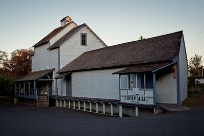
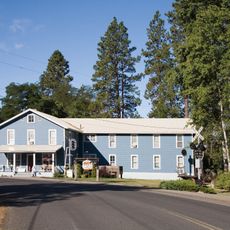
Thorp Mill, Historic watermill in Thorp, United States.

Description

Thorp Mill is a three-story wooden structure standing on the Yakima River bank, preserving the original grinding equipment and machinery from its working years. The building now operates as a museum where visitors can see how the mill processed grain using both traditional and modern techniques.

History

Built between 1880 and 1883, the mill operated without interruption until 1946, when it ceased grinding grain for local farmers. The facility later took on the additional role of generating electricity for nearby communities before operations finally stopped.

Culture

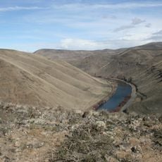
The location reflects how this valley was home to Indigenous peoples long before the mill was built, and the site carries that layered history in its landscape. Walking around the grounds, you sense the connections between different groups who used this river.

Practical

The mill museum is located at 11640 Thorp Highway North and is easy to reach from Interstate 90 by taking Exit 101 and heading north. The property sits directly along the highway, making it simple to find and visit.

Did you know?

The mill is the only one in Washington State that successfully switched from traditional stone grinding to modern roller milling technology during its operating years. This rare technical shift allowed the business to stay competitive and process grain much more efficiently as demand and methods changed.

Location
GPS coordinates
47.07428,-120.68371
Latest update
December 14, 2025 18:00

AroundUs brings together thousands of curated places, local tips, and hidden gems, enriched daily by 60,000 contributors worldwide. Discover all places nearby (Kittitas County).

Around this place
The Gorge Amphitheatre
United States of America

The Gorge Amphitheatre

52.3 km
Mount Stuart
United States of America

Mount Stuart

47.6 km
Kachess Lake
United States of America

Kachess Lake

49 km
Iron Horse State Park
United States of America

Iron Horse State Park

41.7 km
Wild Horse Wind and Solar Facility
United States of America

Wild Horse Wind and Solar Facility

36 km
Whiskey Dick Mountain
United States of America

Whiskey Dick Mountain

34.7 km
Lake Easton State Park
United States of America

Lake Easton State Park

44 km
Fred G. Redmon Bridge
United States of America

Fred G. Redmon Bridge

45.6 km
Dragontail Peak
United States of America

Dragontail Peak

46.4 km
Columbia River Bridge
United States of America

Columbia River Bridge

47.8 km
Olmstead Place State Park
United States of America

Olmstead Place State Park

19.8 km
Wenatchee Confluence State Park
United States of America

Wenatchee Confluence State Park

50.5 km
Squilchuck State Park
United States of America

Squilchuck State Park

35.3 km
Senator George Sellar Bridge
United States of America

Senator George Sellar Bridge

47.5 km
Wenatchee Valley Museum & Cultural Center
United States of America

Wenatchee Valley Museum & Cultural Center

47.9 km
Rock Island Railroad Bridge
United States of America

Rock Island Railroad Bridge

51.8 km
Richard Odabashian Bridge
United States of America

Richard Odabashian Bridge

52.1 km
Umtanum Ridge Water Gap
United States of America

Umtanum Ridge Water Gap

27.1 km
Downtown Wenatchee Historic District
United States of America

Downtown Wenatchee Historic District

48 km
Argonaut Peak
United States of America

Argonaut Peak

46.1 km
Pangborn-Herndon Memorial Site
United States of America

Pangborn-Herndon Memorial Site

51.2 km
Colchuck Glacier
United States of America

Colchuck Glacier

46.7 km
Fifes Peaks
United States of America

Fifes Peaks

49.8 km
Milwaukee Road Bunkhouse
United States of America

Milwaukee Road Bunkhouse

23.7 km
Edgar Rock Lodge
United States of America

Edgar Rock Lodge

32.7 km
Sherpa Glacier
United States of America

Sherpa Glacier

47.2 km
Liberty Theatre
United States of America

Liberty Theatre

48 km
Naches River Railroad Bridge
United States of America

Naches River Railroad Bridge

51.2 km
Show the full map
« Thorp Mill - Historic watermill in Thorp, United States » is provided by Around Us (aroundus.com). Images and texts are derived from Wikimedia project under a Creative Commons license. You are allowed to copy, distribute, and modify copies of this page, under the conditions set by the license, as long as this note is clearly visible.

Discover hidden gems everywhere you go!

From secret cafés to breathtaking viewpoints, skip the crowded tourist spots and find places that match your style. Our app makes it easy with voice search, smart filtering, route optimization, and insider tips from travelers worldwide. Download now for the complete mobile experience.

Around Us App Screenshot

A unique approach to discovering new places

Le Figaro

All the places worth exploring

France Info

A tailor-made excursion in just a few clicks

20 Minutes

Around Us
Travel Guide & Maps
Download

Send to your phone

QR Code
1

Open the camera app on your mobile.

2

Point at the QR code with your camera. A notification will appear.

3

Tap the notification to open the link.