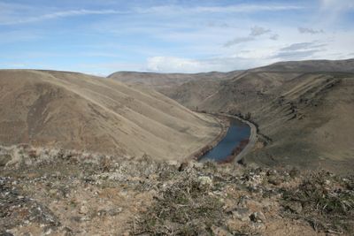
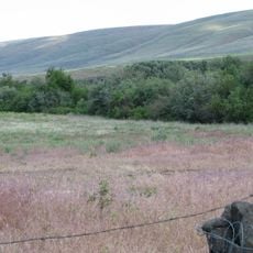
Umtanum Ridge Water Gap, National Natural Landmark in Yakima Canyon, Washington, United States
Umtanum Ridge Water Gap is a natural water passage where the Yakima River cuts through steep basalt cliffs in central Washington. The canyon reveals layers of ancient rock formations that tell the story of how flowing water shaped the landscape over millions of years.
The gap was created millions of years ago when the Yakima River eroded through massive basalt layers that were left by ancient lava flows. The river continues to deepen the canyon as it flows toward the Pacific, carrying the landscape's story with every current.
Geologists and researchers frequently visit this site to study the complex folding patterns and geological processes visible in the rock formations.
The site is reached by driving along Washington State Route 821, which runs beside the Yakima River and offers clear views of the rock formations. The best experience comes from stopping at pullouts along the road where the canyon walls are most dramatic.
The river maintained its original course while the surrounding ridge was pushed upward by geological forces, creating a rare natural example of water's power overcoming rock deformation. This phenomenon reveals how flowing water stays its path even as the land beneath shifts and rises around it.
The community of curious travelers
AroundUs brings together thousands of curated places, local tips, and hidden gems, enriched daily by 60,000 contributors worldwide.