Enable Location

We need your location to show you interesting places around you

Discover nearby places

Find interesting locations and hidden gems around you

Precise directions

Get accurate directions and distances to places

Your location is never shared with other users. It's only used when you tap the location button.

Vantage Bridge

Log in to your account

Start exploring — it's free

Trusted by 65,439 travelers worldwide

Continue with Google
Continue with Apple
or

We will send you a code to connect

By continuing, you accept our Terms and Conditions and our Privacy Policy

Check your inbox

We've sent a pincode in your inbox. Please enter the code below.

Vantage Bridge
Discussion Reviews 1 Photos
4.3k Popularity

Vantage Bridge, Steel arch bridge in Vantage, Washington.

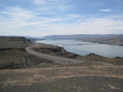
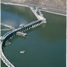
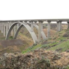
Vantage Bridge is a steel arch bridge over the Columbia River in Washington state, carrying Interstate 90 across the water. It connects the two banks over a total length of about 2,500 feet (763 m), with a central arch spanning the deepest part of the river.

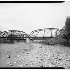
A first bridge was built here in 1927, but it had to be moved when the Wanapum Reservoir flooded the area in the early 1960s. The current structure was completed in 1962 at a new location upstream, built higher to clear the rising water.

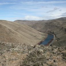
The structure connects the two sides of the Columbia River in an area where ancient petrified forests and outdoor recreation areas meet.

The bridge carries live highway traffic on Interstate 90 and does not allow stopping on the roadway. Good views of the crossing and the river can be found from the riverbank roads and rest areas nearby.

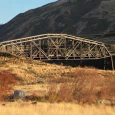
The steel from the original 1927 bridge was not scrapped but reused in 1968 to build the Lyons Ferry Bridge not far away. That decision made Lyons Ferry Bridge the oldest steel cantilever bridge in Washington state.

The community of curious travelers

AroundUs brings together thousands of curated places, local tips, and hidden gems, enriched daily by 60,000 contributors worldwide.

Start exploring
Location
Length
763.2 m
GPS coordinates
46.94360,-119.96700
Latest update
March 3, 2026 08:11
Around this place
The Gorge Amphitheatre
United States of America

The Gorge Amphitheatre

17.7 km
B Reactor
United States of America

B Reactor

42.6 km
Ginkgo Petrified Forest State Park
United States of America

Ginkgo Petrified Forest State Park

2.8 km
Moses Lake
United States of America

Moses Lake

52.1 km
Iron Horse State Park
United States of America

Iron Horse State Park

17.8 km
Grandfather Cuts Loose the Ponies
United States of America

Grandfather Cuts Loose the Ponies

2.5 km
Potholes State Park
United States of America

Potholes State Park

47 km
Wanapum Dam
United States of America

Wanapum Dam

7.6 km
Potholes Reservoir
United States of America

Potholes Reservoir

51.5 km
Priest Rapids Dam
United States of America

Priest Rapids Dam

33.7 km
Wild Horse Wind and Solar Facility
United States of America

Wild Horse Wind and Solar Facility

20.7 km
Rock Island Dam
United States of America

Rock Island Dam

45.4 km
Whiskey Dick Mountain
United States of America

Whiskey Dick Mountain

22.1 km
Fred G. Redmon Bridge
United States of America

Fred G. Redmon Bridge

45.2 km
Columbia National Wildlife Refuge
United States of America

Columbia National Wildlife Refuge

34.3 km
Olmstead Place State Park
United States of America

Olmstead Place State Park

38.5 km
Beverly Railroad Bridge
United States of America

Beverly Railroad Bridge

12.6 km
Priest Rapids
United States of America

Priest Rapids

21 km
Squilchuck State Park
United States of America

Squilchuck State Park

51.1 km
Vernita Bridge
United States of America

Vernita Bridge

38 km
Rock Island Railroad Bridge
United States of America

Rock Island Railroad Bridge

49.2 km
Umtanum Ridge Water Gap
United States of America

Umtanum Ridge Water Gap

45.1 km
Wanapum Lake
United States of America

Wanapum Lake

7.9 km
Canada

Sentinel Gap

15.6 km
Grant County Courthouse
United States of America

Grant County Courthouse

52.5 km
Grant County Fairgrounds
United States of America

Grant County Fairgrounds

54.8 km
Naches River Railroad Bridge
United States of America

Naches River Railroad Bridge

54.9 km
Quincy Aquatic Center
United States of America

Quincy Aquatic Center

33.5 km
Show the full map
Reviews
Share your experience

No review yet

Discussions
Start a discussion...

No discussion yet

« Vantage Bridge - Steel arch bridge in Vantage, Washington » is provided by Around Us (aroundus.com). Images and texts are derived from Wikimedia project under a Creative Commons license. You are allowed to copy, distribute, and modify copies of this page, under the conditions set by the license, as long as this note is clearly visible.

Discover hidden gems everywhere you go!

From secret cafés to breathtaking viewpoints, skip the crowded tourist spots and find places that match your style. Our app makes it easy with voice search, smart filtering, route optimization, and insider tips from travelers worldwide. Download now for the complete mobile experience.

Around Us App Screenshot

A unique approach to discovering new places

Le Figaro

All the places worth exploring

France Info

A tailor-made excursion in just a few clicks

20 Minutes

Around Us
Travel Guide & Maps
Download

Send to your phone

QR Code
1

Open the camera app on your mobile.

2

Point at the QR code with your camera. A notification will appear.

3

Tap the notification to open the link.