Enable Location

We need your location to show you interesting places around you

Discover nearby places

Find interesting locations and hidden gems around you

Precise directions

Get accurate directions and distances to places

Your location is never shared with other users. It's only used when you tap the location button.

Potholes Reservoir

Log in to your account

Start exploring — it's free

Trusted by 62,339 travelers worldwide

Continue with Google
Continue with Apple
or

We will send you a code to connect

By continuing, you accept our Terms and Conditions and our Privacy Policy

Check your inbox

We've sent a pincode in your inbox. Please enter the code below.

Potholes Reservoir

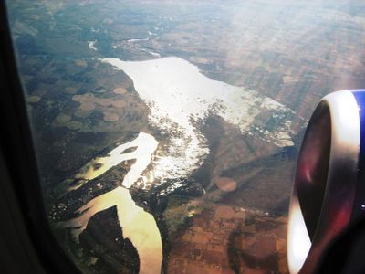
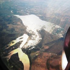
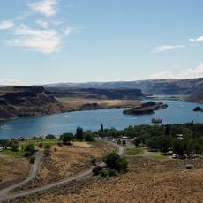
Potholes Reservoir, Central Washington lake, United States

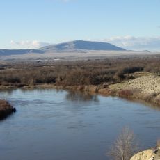
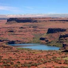
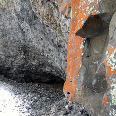
Potholes Reservoir is a large body of water in central Washington formed by dam construction on a stream. The lake is surrounded by open land with low vegetation, sand dunes, and rock outcrops left behind by Ice Age floods.

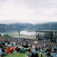
The reservoir was built many decades ago as part of a large irrigation project to store water for regional farming. Over time it shifted from a purely functional structure to an important site for recreation and nature observation.

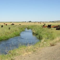
The reservoir brings together locals and visitors who come to fish, camp, and spend time outdoors together. The setting reflects the relationship between water and dry landscapes that defines this part of Washington.

The lake is easy to reach by roads that lead close to the shoreline, and there are picnic spots and restrooms on-site. Visitors should bring water, sunscreen, and comfortable shoes since the area is open and exposed to sun.

The landscape was shaped by massive Ice Age floods millions of years ago, leaving behind rock formations and sand dunes that still dominate the terrain. Small islands appear and disappear with changing water levels, creating ever-shifting habitats for migrating birds and wintering eagles.

The community of curious travelers

AroundUs brings together thousands of curated places, local tips, and hidden gems, enriched daily by 60,000 contributors worldwide.

Start exploring
Location
GPS coordinates
46.98250,-119.29111
Latest update
February 7, 2026 11:01
Around this place
The Gorge Amphitheatre
United States of America

The Gorge Amphitheatre

55 km
B Reactor
United States of America

B Reactor

47.7 km
Ginkgo Petrified Forest State Park
United States of America

Ginkgo Petrified Forest State Park

54.2 km
Moses Lake
United States of America

Moses Lake

17.5 km
Iron Horse State Park
United States of America

Iron Horse State Park

69.2 km
Rattlesnake Mountain
United States of America

Rattlesnake Mountain

68.6 km
Grandfather Cuts Loose the Ponies
United States of America

Grandfather Cuts Loose the Ponies

51 km
Sun Lakes-Dry Falls State Park
United States of America

Sun Lakes-Dry Falls State Park

68.5 km
Potholes State Park
United States of America

Potholes State Park

4.5 km
Wanapum Dam
United States of America

Wanapum Dam

53 km
Priest Rapids Dam
United States of America

Priest Rapids Dam

60.4 km
Drumheller Channels National Natural Landmark
United States of America

Drumheller Channels National Natural Landmark

7.3 km
Crab Creek
United States of America

Crab Creek

58.5 km
Columbia Plateau State Park Trail
United States of America

Columbia Plateau State Park Trail

67.5 km
Abraham Lincoln
United States of America

Abraham Lincoln

24.4 km
Vantage Bridge
United States of America

Vantage Bridge

51.5 km
Columbia National Wildlife Refuge
United States of America

Columbia National Wildlife Refuge

23.7 km
Lake Lenore Caves State Park
United States of America

Lake Lenore Caves State Park

56.5 km
Beverly Railroad Bridge
United States of America

Beverly Railroad Bridge

52.7 km
Priest Rapids
United States of America

Priest Rapids

57.7 km
Vernita Bridge
United States of America

Vernita Bridge

50.7 km
Wanapum Lake
United States of America

Wanapum Lake

53.2 km
Canada

Sentinel Gap

52.7 km
Surf 'n Slide Water Park
United States of America

Surf 'n Slide Water Park

16.1 km
Grant County Courthouse
United States of America

Grant County Courthouse

42.7 km
Grant County Fairgrounds
United States of America

Grant County Fairgrounds

17.8 km
Seivers Brothers Ranchhouse and Barn
United States of America

Seivers Brothers Ranchhouse and Barn

60.1 km
Moses Lake Museum & Art Center
United States of America

Moses Lake Museum & Art Center

16.6 km
Show the full map
« Potholes Reservoir - Central Washington lake, United States » is provided by Around Us (aroundus.com). Images and texts are derived from Wikimedia project under a Creative Commons license. You are allowed to copy, distribute, and modify copies of this page, under the conditions set by the license, as long as this note is clearly visible.

Discover hidden gems everywhere you go!

From secret cafés to breathtaking viewpoints, skip the crowded tourist spots and find places that match your style. Our app makes it easy with voice search, smart filtering, route optimization, and insider tips from travelers worldwide. Download now for the complete mobile experience.

Around Us App Screenshot

A unique approach to discovering new places

Le Figaro

All the places worth exploring

France Info

A tailor-made excursion in just a few clicks

20 Minutes

Around Us
Travel Guide & Maps
Download

Send to your phone

QR Code
1

Open the camera app on your mobile.

2

Point at the QR code with your camera. A notification will appear.

3

Tap the notification to open the link.