Vernita Bridge

Log in to your account

AroundUs is a community-driven map of interesting places, built by curious explorers like you. It grows with every review, story, and photo you share.
Connect to save your favorite spots, contribute locations, and create personalized routes.
Continue with Google
Continue with Apple
Continue with X
Continue with Facebook
Continue with email
By continuing, you accept our Terms and Conditions and our Privacy Policy
Create an account
Add to collection
Map
Suggest a change
Share

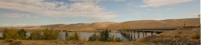
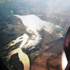
Vernita Bridge, State road bridge over Columbia River near Desert Aire, Washington.

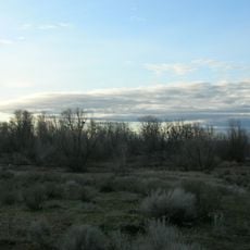
Vernita Bridge is a highway bridge that crosses the Columbia River connecting Grant County and Benton County in Washington state along State Route 24. The structure carries traffic across the river at a point where the landscape transitions between different agricultural and semi-arid regions.

The bridge opened in 1965 to replace a ferry service that had operated since 1901. The area was evacuated starting in 1943 as part of the Manhattan Project, leading to the closure of the earlier crossing.

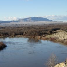
The bridge access area functions as a central gathering point for recreational fishing activities, particularly during the fall Chinook salmon season.

The bridge is easily accessible via Washington State Route 24, which runs through the region and provides parking areas nearby. The surrounding area offers good visibility and clear roads, making it straightforward to find and cross.

A weather station in this area recorded one of the highest temperatures ever measured in Washington state. Such extreme conditions shaped the climate and landscape of the surrounding semi-arid region.

Location: Washington

Inception: 1965

Official opening: 1965

GPS coordinates: 46.64250,-119.73300

Latest update: December 13, 2025 17:07

Photos
Around this place
Pacific Northwest National Laboratory
United States of America

Pacific Northwest National Laboratory

48.3 km
B Reactor
United States of America

B Reactor

6.7 km
Ginkgo Petrified Forest State Park
United States of America

Ginkgo Petrified Forest State Park

39.8 km
Gold Coast Historic District
United States of America

Gold Coast Historic District

52.2 km
Teapot Dome Service Station
United States of America

Teapot Dome Service Station

48.4 km
Iron Horse State Park
United States of America

Iron Horse State Park

45.7 km
Rattlesnake Mountain
United States of America

Rattlesnake Mountain

27.9 km
Grandfather Cuts Loose the Ponies
United States of America

Grandfather Cuts Loose the Ponies

40 km
Potholes State Park
United States of America

Potholes State Park

47.5 km
Wanapum Dam
United States of America

Wanapum Dam

31.6 km
Potholes Reservoir
United States of America

Potholes Reservoir

50.7 km
Priest Rapids Dam
United States of America

Priest Rapids Dam

13.5 km
Vantage Bridge
United States of America

Vantage Bridge

38 km
Columbia National Wildlife Refuge
United States of America

Columbia National Wildlife Refuge

27.6 km
Beverly Railroad Bridge
United States of America

Beverly Railroad Bridge

26.6 km
Priest Rapids
United States of America

Priest Rapids

22.1 km
Wanapum Lake
United States of America

Wanapum Lake

31.5 km
Benton City – Kiona Bridge
United States of America

Benton City – Kiona Bridge

47.7 km
Canada

Sentinel Gap

23.7 km
Yakima Indian Agency Building
United States of America

Yakima Indian Agency Building

53.4 km
Compass High School
United States of America

Compass High School

45.3 km
J. W. Carey House
United States of America

J. W. Carey House

49.7 km
2800 Polar Way
United States of America

2800 Polar Way

47.4 km
USS Triton Submarine
United States of America

USS Triton Submarine

48.3 km
West Richland Golf Course
United States of America

West Richland Golf Course

48.4 km
Railway Museum
United States of America

Railway Museum

53.1 km
Pix Gallery
United States of America

Pix Gallery

53.2 km
Liberty Theater
United States of America

Liberty Theater

53.4 km
Show the full map
Reviews

Visited this place? Tap the stars to rate it and share your experience / photos with the community! Try now! You can cancel it anytime.

« Vernita Bridge - State road bridge over Columbia River near Desert Aire, Washington » is provided by Around Us (aroundus.com). Images and texts are derived from Wikimedia project under a Creative Commons license. You are allowed to copy, distribute, and modify copies of this page, under the conditions set by the license, as long as this note is clearly visible.

Discover hidden gems everywhere you go!

From secret cafés to breathtaking viewpoints, skip the crowded tourist spots and find places that match your style. Our app makes it easy with voice search, smart filtering, route optimization, and insider tips from travelers worldwide. Download now for the complete mobile experience.

Around Us App Screenshot

A unique approach to discovering new places

Le Figaro

All the places worth exploring

France Info

A tailor-made excursion in just a few clicks

20 Minutes