Whiskey Dick Mountain

Log in to your account

AroundUs is a community-driven map of interesting places, built by curious explorers like you. It grows with every review, story, and photo you share.
Connect to save your favorite spots, contribute locations, and create personalized routes.
Continue with Google
Continue with Apple
Continue with X
Continue with Facebook
Continue with email
By continuing, you accept our Terms and Conditions and our Privacy Policy
Create an account

Whiskey Dick Mountain

Add to collection
Map
Suggest a change
Share

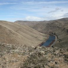
Whiskey Dick Mountain, Mountain summit in Kittitas County, Washington, United States.

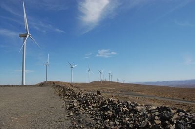
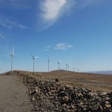
Whiskey Dick Mountain is a summit in Kittitas County, Washington, with mixed conifer forests on the upper slopes and shrublands in the lower zones within the L.T. Murray Wildlife Area. The landscape reflects different land uses, including the Wild Horse Wind and Solar Facility that operates on the southwestern side.

The mountain served as a geographical marker for early settlers in Kittitas County who were developing agricultural and ranching operations. Modern renewable energy infrastructure arrived much later on its southwestern side.

The mountain serves as a meeting point between natural preservation and modern technology, with the Wild Horse Wind and Solar Facility operating on its southwest flank.

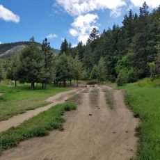
Visitors need permits from Puget Sound Energy to access the hiking trails leading to the summit, as much of the land is privately owned. Planning ahead helps clarify access requirements and local conditions.

The mountain hosts both wind and solar energy generation facilities integrated into its landscape. This combination of a wildlife area and renewable energy production is uncommon in the region.

Location: Washington

Location: Kittitas County

GPS coordinates: 47.02513,-120.23201

Latest update: December 10, 2025 16:30

Photos
Around this place
The Gorge Amphitheatre
United States of America

The Gorge Amphitheatre

19.9 km
Ginkgo Petrified Forest State Park
United States of America

Ginkgo Petrified Forest State Park

19.4 km
Iron Horse State Park
United States of America

Iron Horse State Park

13.7 km
Grandfather Cuts Loose the Ponies
United States of America

Grandfather Cuts Loose the Ponies

21.6 km
Wanapum Dam
United States of America

Wanapum Dam

25.9 km
Priest Rapids Dam
United States of America

Priest Rapids Dam

49.1 km
Wild Horse Wind and Solar Facility
United States of America

Wild Horse Wind and Solar Facility

1.4 km
Rock Island Dam
United States of America

Rock Island Dam

36.8 km
Vantage Bridge
United States of America

Vantage Bridge

22.1 km
Fred G. Redmon Bridge
United States of America

Fred G. Redmon Bridge

39.5 km
Columbia River Bridge
United States of America

Columbia River Bridge

43.6 km
Olmstead Place State Park
United States of America

Olmstead Place State Park

19.2 km
Wenatchee Confluence State Park
United States of America

Wenatchee Confluence State Park

48.8 km
Beverly Railroad Bridge
United States of America

Beverly Railroad Bridge

30.5 km
Priest Rapids
United States of America

Priest Rapids

36 km
Squilchuck State Park
United States of America

Squilchuck State Park

33.5 km
Senator George Sellar Bridge
United States of America

Senator George Sellar Bridge

43.1 km
Wenatchee Valley Museum & Cultural Center
United States of America

Wenatchee Valley Museum & Cultural Center

44.6 km
Rock Island Railroad Bridge
United States of America

Rock Island Railroad Bridge

38.6 km
Umtanum Ridge Water Gap
United States of America

Umtanum Ridge Water Gap

30.7 km
Wanapum Lake
United States of America

Wanapum Lake

26 km
Downtown Wenatchee Historic District
United States of America

Downtown Wenatchee Historic District

44.7 km
Canada

Sentinel Gap

33.4 km
Thorp Mill
United States of America

Thorp Mill

34.7 km
Pangborn-Herndon Memorial Site
United States of America

Pangborn-Herndon Memorial Site

46.7 km
Liberty Theatre
United States of America

Liberty Theatre

44.8 km
Naches River Railroad Bridge
United States of America

Naches River Railroad Bridge

49.4 km
Rock Island Pool
United States of America

Rock Island Pool

36.8 km
Show the full map
Reviews

Visited this place? Tap the stars to rate it and share your experience / photos with the community! Try now! You can cancel it anytime.

« Whiskey Dick Mountain - Mountain summit in Kittitas County, Washington, United States » is provided by Around Us (aroundus.com). Images and texts are derived from Wikimedia project under a Creative Commons license. You are allowed to copy, distribute, and modify copies of this page, under the conditions set by the license, as long as this note is clearly visible.

Discover hidden gems everywhere you go!

From secret cafés to breathtaking viewpoints, skip the crowded tourist spots and find places that match your style. Our app makes it easy with voice search, smart filtering, route optimization, and insider tips from travelers worldwide. Download now for the complete mobile experience.

Around Us App Screenshot

A unique approach to discovering new places

Le Figaro

All the places worth exploring

France Info

A tailor-made excursion in just a few clicks

20 Minutes