Chest opened
+${chestReward.xp} XP
Explorer
NOUVEAU ×${chestReward.collectible.quantity}
tapez pour fermer

See the monuments around you in AR Open chests in the app

Around Us is built for your phone — point your camera at the streets and discover the monuments and places around you in augmented reality. Around Us is built for your phone — chests unlock when you walk, explore and capture nearby places.

Enable Location

We need your location to show you interesting places around you

Discover nearby places

Find interesting locations and hidden gems around you

Precise directions

Get accurate directions and distances to places

Your location is never shared with other users. It's only used when you tap the location button.

Log in to your account

Start exploring — it's free

Trusted by 82,374 travelers worldwide

Continue with Google
Continue with Apple
or

We will send you a code to connect

By continuing, you accept our Terms and Conditions and our Privacy Policy

Check your inbox

We've sent a pincode in your inbox. Please enter the code below.

Swift Dam
Discussion Reviews Photo
3k Popularity

Swift Dam, Arch dam in Pondera County, Montana, United States.

Swift Dam is an arch dam built across Birch Creek at the southern edge of the Blackfeet Indian Reservation, standing 205 feet tall and stretching 573 feet across the waterway. The concrete structure holds back water to serve agricultural needs across a broad area.

The original dam built in 1914 failed during major flooding in 1964, leading to its replacement with the current concrete structure completed in 1967. The event prompted significant changes to how such structures were designed for safety.

The dam site follows a historic trail where Native Americans traveled for thousands of years between hunting grounds and seasonal camps. You can sense this deep connection to the land in how the local communities relate to the waterway today.

The dam is accessible from nearby roads in the region and visible from several vantage points. Visitors should check conditions before heading out, particularly during high water periods when water levels can affect the surrounding area.

The dam complex includes a secondary earthen dike running parallel to the main concrete structure, forming a dual protection system. This layered design shows how engineers solve water management challenges through multiple barriers.

The community of curious travelers

AroundUs brings together thousands of curated places, local tips, and hidden gems, enriched daily by 60,000 contributors worldwide.

Start exploring
Location
GPS coordinates
48.16310,-112.87200
Latest update
August 5, 2026 03:32
Around this place
Two Medicine Formation
Canada

Two Medicine Formation

43.7 km
Marias Pass
United States of America

Marias Pass

39.8 km
Great Bear Wilderness
United States of America

Great Bear Wilderness

49.3 km
Summit Mountain
United States of America

Summit Mountain

42.6 km
Pray Lake
United States of America

Pray Lake

51.6 km
United States of America

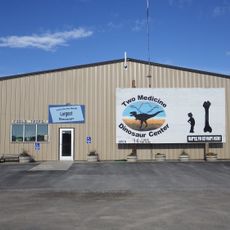
Two Medicine Dinosaur Center

46.4 km
Two Medicine Campground Camptender's Cabin
United States of America

Two Medicine Campground Camptender's Cabin

51.5 km
Swanson Boathouse
United States of America

Swanson Boathouse

51.3 km
East Glacier Ranger Station Historic District
United States of America

East Glacier Ranger Station Historic District

41 km
Gable Peaks
United States of America

Gable Peaks

26.4 km
Museum of the Plains Indian
United States of America

Museum of the Plains Indian

45.2 km
Fielding Snowshoe Patrol Cabin
United States of America

Fielding Snowshoe Patrol Cabin

45.5 km
The Montana Dinosaur Center
United States of America

The Montana Dinosaur Center

46.6 km
Two Medicine Campground Amphitheater
United States of America

Two Medicine Campground Amphitheater

51.5 km
United States of America

Blackleaf Wildlife Management Area

25.5 km
United States of America

Scenic viewpoint, parking lot

51.1 km
United States of America

Teddy Bear Fence

35.9 km
United States of America

Statue

40.3 km
United States of America

Scenic viewpoint, parking lot

51.3 km
United States of America

Teddy Bear Fence

35.9 km
United States of America

Running Eagle Falls

51.5 km
United States of America

Scenic viewpoint

51.4 km
United States of America

Scenic viewpoint

50.4 km
United States of America

Appistoki Falls

50.3 km
United States of America

Rockwell Falls

50.9 km
United States of America

Waterfall

24.4 km
United States of America

Aster falls

50.7 km
United States of America

Dean Falls

40.7 km
Show the full map
Reviews
Share your experience

No review yet

Discussions
Start a discussion...

No discussion yet

« Swift Dam - Arch dam in Pondera County, Montana, United States » is provided by Around Us (aroundus.com). Images and texts are derived from Wikimedia project under a Creative Commons license. You are allowed to copy, distribute, and modify copies of this page, under the conditions set by the license, as long as this note is clearly visible.

Discover hidden gems everywhere you go!

From secret cafés to breathtaking viewpoints, skip the crowded tourist spots and find places that match your style. Our app makes it easy with voice search, smart filtering, route optimization, and insider tips from travelers worldwide. Download now for the complete mobile experience.

Around Us App Screenshot

A unique approach to discovering new places

Le Figaro

All the places worth exploring

France Info

A tailor-made excursion in just a few clicks

20 Minutes

Around Us
Travel Guide & Maps
Download

Send to your phone

QR Code
1

Open the camera app on your mobile.

2

Point at the QR code with your camera. A notification will appear.

3

Tap the notification to open the link.