Oldman Formation, Geological formation in southern Alberta, Canada.
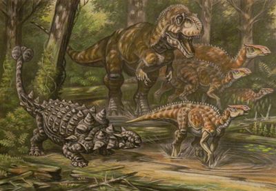
The Oldman Formation is a Late Cretaceous geological layer composed of sandstone and mudstone deposited between the St. Mary River and Lethbridge in southern Alberta. Its visible strata display the patterns of ancient river channels and floodplains that shaped the sediment layers over millions of years.
Geologists formally identified this formation in 1940 based on its distinctive rock layers and depositional patterns across southern Alberta. Subsequent fossil discoveries throughout the decades transformed it into a key research site for understanding Late Cretaceous life in North America.
The formation draws paleontologists and museum researchers due to its fossil wealth, and its discoveries have shaped how scientists understand Late Cretaceous ecosystems. Visitors walking through exposed sections can observe how ancient river deposits preserve traces of long-extinct animals.
The exposed sections are accessible across the southern prairie landscape, best explored during field trips or guided walks from spring through fall. Sturdy footwear and weather protection are advisable since the open slopes can shift between wet and dry conditions.
The sandstone layers erode into distinctive badland formations that resemble sculpted river banks, revealing the original arrangement of sediments before modern weathering altered them. This natural carving process makes visible the internal structure of ancient floodplain deposits.
The community of curious travelers
AroundUs brings together thousands of curated places, local tips, and hidden gems, enriched daily by 60,000 contributors worldwide.