Legend Rock

Log in to your account

AroundUs is a community-driven map of interesting places, built by curious explorers like you. It grows with every review, story, and photo you share.
Connect to save your favorite spots, contribute locations, and create personalized routes.
Continue with Google
Continue with Apple
Continue with X
Continue with Facebook
Continue with email
By continuing, you accept our Terms and Conditions and our Privacy Policy
Create an account
Add to collection
Map
Suggest a change
Share

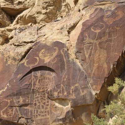
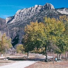
Legend Rock, Petroglyph archaeological site near Thermopolis, Wyoming, US

Legend Rock is an archaeological site near Thermopolis featuring a sandstone cliff rising about 130 meters (400 feet) high. The cliff holds over 90 panels of indigenous carvings depicting more than 300 animal and human figures created in stone over centuries.

Indigenous peoples carved the petroglyph panels between the 6th and 17th centuries on the sandstone surfaces. The site remained largely forgotten until modern times when it was rediscovered and recognized as an important record of prehistoric Plains cultures.

The carvings depict animals like elk, deer, and bears alongside human figures wearing elaborate headdresses. These images show how indigenous peoples communicated their observations and beliefs through carved symbols in stone.

The site provides a visitor center and interpretive trails leading to the carved panels at various viewpoints. During winter months, access is limited and advance arrangements are necessary, so plan your visit accordingly.

The carvings display striking variation in size, ranging from a few inches to over 4 feet (1.2 meters) tall. Many figures overlap one another and feature interior-line designs, an unusual artistic approach that sets these petroglyphs apart from others in the region.

Location: Wyoming

GPS coordinates: 43.79810,-108.60100

Latest update: December 6, 2025 17:42

Photos
Natural wonders and historic sites in Wyoming

Wyoming preserves geological sites that include thermal springs, canyons, and rock formations. The state protects historic locations such as forts, rock art, and dinosaur tracks. Devils Tower rises 1,267 feet (386 meters) above the terrain and represents a significant geological formation. Fossil...

Around this place
Hot Springs State Park
United States of America

Hot Springs State Park

36.1 km
Wind River Canyon
United States of America

Wind River Canyon

45.9 km
Wyoming Dinosaur Center
United States of America

Wyoming Dinosaur Center

36.5 km
Francs Peak
United States of America

Francs Peak

61.3 km
Boysen Reservoir
United States of America

Boysen Reservoir

54.6 km
Boysen State Park
United States of America

Boysen State Park

54.5 km
Wyoming Basin
United States of America

Wyoming Basin

53.2 km
Buffalo Bill Boyhood Home
United States of America

Buffalo Bill Boyhood Home

88.8 km
Anderson Lodge
United States of America

Anderson Lodge

74.7 km
Anchor Dam
United States of America

Anchor Dam

23.4 km
CQA Four Mile Bridge
United States of America

CQA Four Mile Bridge

39.1 km
BMU Bridge over Wind River
United States of America

BMU Bridge over Wind River

73.4 km
EFP Bridge over Owl Creek
United States of America

EFP Bridge over Owl Creek

20.5 km
ELY Wind River Diversion Dam Bridge
United States of America

ELY Wind River Diversion Dam Bridge

69.9 km
First National Bank of Meeteetse
United States of America

First National Bank of Meeteetse

44.5 km
Worland House
United States of America

Worland House

56.7 km
Alex Halone House
United States of America

Alex Halone House

36.4 km
Downtown Thermopolis Historic District
United States of America

Downtown Thermopolis Historic District

35.7 km
National Museum of Military Vehicles
United States of America

National Museum of Military Vehicles

80.7 km
Torrey Lake Historic District
United States of America

Torrey Lake Historic District

85.6 km
C. H. King Company and First National Bank of Shoshoni
United States of America

C. H. King Company and First National Bank of Shoshoni

74.2 km
EJP County Line Bridge
United States of America

EJP County Line Bridge

84.1 km
Rairden Bridge
United States of America

Rairden Bridge

70.5 km
Amoretti, Welty, Helmer & Co Bank
United States of America

Amoretti, Welty, Helmer & Co Bank

88.2 km
Washakie Museum & Cultural Center
United States of America

Washakie Museum & Cultural Center

58.3 km
Steamboat Geyser
United States of America

Steamboat Geyser

63.6 km
Acme Theatre
United States of America

Acme Theatre

87.8 km
Thermopolis Swinging Bridge
United States of America

Thermopolis Swinging Bridge

36.2 km
Show the full map
Reviews

Visited this place? Tap the stars to rate it and share your experience / photos with the community! Try now! You can cancel it anytime.

« Legend Rock - Petroglyph archaeological site near Thermopolis, Wyoming, US » is provided by Around Us (aroundus.com). Images and texts are derived from Wikimedia project under a Creative Commons license. You are allowed to copy, distribute, and modify copies of this page, under the conditions set by the license, as long as this note is clearly visible.

Discover hidden gems everywhere you go!

From secret cafés to breathtaking viewpoints, skip the crowded tourist spots and find places that match your style. Our app makes it easy with voice search, smart filtering, route optimization, and insider tips from travelers worldwide. Download now for the complete mobile experience.

Around Us App Screenshot

A unique approach to discovering new places

Le Figaro

All the places worth exploring

France Info

A tailor-made excursion in just a few clicks

20 Minutes