Enable Location

We need your location to show you interesting places around you

Discover nearby places

Find interesting locations and hidden gems around you

Precise directions

Get accurate directions and distances to places

Your location is never shared with other users. It's only used when you tap the location button.

Sheridan Lake

Log in to your account

Start exploring — it's free

Trusted by 62,488 travelers worldwide

Continue with Google
Continue with Apple
or

We will send you a code to connect

By continuing, you accept our Terms and Conditions and our Privacy Policy

Check your inbox

We've sent a pincode in your inbox. Please enter the code below.

Sheridan Lake

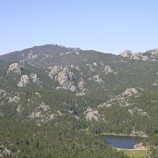
Sheridan Lake, reservoir in Pennington County, South Dakota

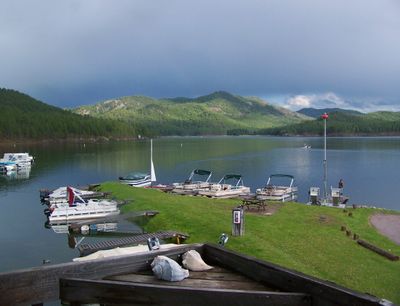
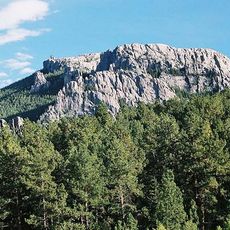
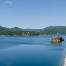
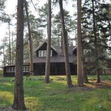
Sheridan Lake is a large reservoir in the Black Hills of western South Dakota, covering about 400 acres and sitting at an elevation above 4,600 feet. The lake was formed in 1939 by a dam built across Spring Creek, and it features two public beaches, boat launches, campgrounds, and fishing docks.

The lake was built in 1939 as part of a broader American program to create recreational spaces, with construction done by the Civilian Conservation Corps. Its name comes from Sheridan, which was the first county seat of Pennington County located in this region of the Black Hills.

The lake takes its name from Sheridan, the first county seat of Pennington County, connecting early settlement history with modern outdoor life. Today it serves as a place where local people and visitors spend time in nature and experience the rhythm of the seasons.

The lake is easy to reach via US Route 385 and offers parking, toilets, and picnic areas at both beaches plus two boat ramps on each side. Campsites operate on a first-come, first-served basis except for some reserved spots, so arrive early especially during peak season.

The lake maintains a steady water level throughout the year because it is not used for flood control or irrigation, making it a reliable spot for fishing and boating. This characteristic sets it apart from many other lakes in the region that experience seasonal water fluctuations.

The community of curious travelers

AroundUs brings together thousands of curated places, local tips, and hidden gems, enriched daily by 60,000 contributors worldwide.

Start exploring
Location
GPS coordinates
43.97500,-103.45111
Latest update
February 7, 2026 11:00
Around this place
Mount Rushmore National Memorial
United States of America

Mount Rushmore National Memorial

10.8 km
Mount Rushmore
United States of America

Mount Rushmore

10.8 km
Crazy Horse Memorial
United States of America

Crazy Horse Memorial

20.7 km
Needles
United States of America

Needles

17.3 km
Black Elk Peak
United States of America

Black Elk Peak

13.7 km
Pactola Lake
United States of America

Pactola Lake

11.4 km
Dinosaur Park
United States of America

Dinosaur Park

19.9 km
United States of America

Stratobowl

8.5 km
Black Hills Institute of Geological Research, Inc.
United States of America

Black Hills Institute of Geological Research, Inc.

11 km
Rapid City High School
United States of America

Rapid City High School

21.1 km
Black Elk Wilderness
United States of America

Black Elk Wilderness

15.4 km
Keystone Wye
United States of America

Keystone Wye

5.6 km
Rushmore Cave
United States of America

Rushmore Cave

14.7 km
Black Hills Playhouse
United States of America

Black Hills Playhouse

18.8 km
Sitting Bull Crystal Cavern Dance Pavilion
United States of America

Sitting Bull Crystal Cavern Dance Pavilion

11 km
Rapid City Public Library
United States of America

Rapid City Public Library

21.2 km
Lincoln Borglum Museum
United States of America

Lincoln Borglum Museum

10.9 km
Cathedral of Our Lady of Perpetual Help
United States of America

Cathedral of Our Lady of Perpetual Help

20.3 km
Big Thunder Gold Mine
United States of America

Big Thunder Gold Mine

9.3 km
Emmanuel Episcopal Church
United States of America

Emmanuel Episcopal Church

21.1 km
Pap Madison Cabin
United States of America

Pap Madison Cabin

20.9 km
The National Presidential Wax Museum
United States of America

The National Presidential Wax Museum

9.9 km
Keystone School
United States of America

Keystone School

9.2 km
First Congregational Church
United States of America

First Congregational Church

21.2 km
Peter Norbeck Summer House
United States of America

Peter Norbeck Summer House

19.3 km
Black Elk Peak Lookout Tower
United States of America

Black Elk Peak Lookout Tower

13.7 km
Sunday Gulch Trail
United States of America

Sunday Gulch Trail

17 km
Civilian Conservation Corps Museum
United States of America

Civilian Conservation Corps Museum

9.7 km
Show the full map
« Sheridan Lake - reservoir in Pennington County, South Dakota » is provided by Around Us (aroundus.com). Images and texts are derived from Wikimedia project under a Creative Commons license. You are allowed to copy, distribute, and modify copies of this page, under the conditions set by the license, as long as this note is clearly visible.

Discover hidden gems everywhere you go!

From secret cafés to breathtaking viewpoints, skip the crowded tourist spots and find places that match your style. Our app makes it easy with voice search, smart filtering, route optimization, and insider tips from travelers worldwide. Download now for the complete mobile experience.

Around Us App Screenshot

A unique approach to discovering new places

Le Figaro

All the places worth exploring

France Info

A tailor-made excursion in just a few clicks

20 Minutes

Around Us
Travel Guide & Maps
Download

Send to your phone

QR Code
1

Open the camera app on your mobile.

2

Point at the QR code with your camera. A notification will appear.

3

Tap the notification to open the link.