Enable Location

We need your location to show you interesting places around you

Discover nearby places

Find interesting locations and hidden gems around you

Precise directions

Get accurate directions and distances to places

Your location is never shared with other users. It's only used when you tap the location button.

Watford City

Log in to your account

Start exploring — it's free

Trusted by 61,912 travelers worldwide

Continue with Google
Continue with Apple
or

We will send you a code to connect

By continuing, you accept our Terms and Conditions and our Privacy Policy

Check your inbox

We've sent a pincode in your inbox. Please enter the code below.

Watford City, County seat in McKenzie County, North Dakota, United States

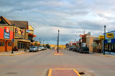
Watford City is the county seat of McKenzie County in North Dakota and serves as the administrative hub for the region. The town spreads across several square miles with streets laid out in a grid pattern and sits in an area shaped by oil production and farming.

The city was founded in 1914 by businessmen expecting the arrival of the Great Northern Railroad. They named it after Vaughan G. Morris's hometown of Watford in Ontario, which he chose to honor his Canadian roots in this new Dakota settlement.

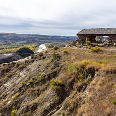
The Theodore Roosevelt National Park North Unit near Watford City provides connections to Native American heritage and early frontier settlement patterns.

A local transit system offers weekday connections between residential areas, shopping districts, and medical facilities throughout town. The location sits in the heart of a rural region, so it makes sense to check on available services before visiting.

The Rough Rider Center is a modern multipurpose facility serving the town as a sports venue, concert hall, and gathering space. The building shows how this rural community invested in infrastructure to offer residents and visitors a range of activities.

The community of curious travelers

AroundUs brings together thousands of curated places, local tips, and hidden gems, enriched daily by 60,000 contributors worldwide.

Start exploring
Location
Inception
1914
Elevation above the sea
646 m
GPS coordinates
47.80250,-103.28056
Latest update
December 20, 2025 15:14
Around this place
United States of America

Theodore Roosevelt Wilderness

27.7 km
Four Bears Bridge
United States of America

Four Bears Bridge

57.1 km
Fairview Lift Bridge
United States of America

Fairview Lift Bridge

53 km
Grassy Butte Post Office
United States of America

Grassy Butte Post Office

45.5 km
United States of America

Verendrye National Monument

58.4 km
United States of America

Little Missouri State Park

49.7 km
United States of America

Lewis and Clark State Park

35 km
Crow Flies High State Recreation Area
United States of America

Crow Flies High State Recreation Area

58.4 km
United States of America

Two Top and Big Top Mesa

57.8 km
United States of America

Lost Bridge

45.2 km
James Memorial Library
United States of America

James Memorial Library

46.4 km
Old U.S. Post Office
United States of America

Old U.S. Post Office

46.2 km
United States of America

Sandstone School

5.3 km
United States of America

Buckhorn Trail

23.3 km
United States of America

Clarks Creek Public Use Area

46.2 km
United States of America

David Watts Bluff

39.5 km
United States of America

Two Top Research Natural Area

57.8 km
United States of America

Sundheim Park

52.1 km
United States of America

Sliding Bluff

29.4 km
River Bend Overlook
United States of America

River Bend Overlook

22.8 km
United States of America

Glass Bluffs

50.1 km
Cannonball Concretions Pullout
United States of America

Cannonball Concretions Pullout

23.3 km
United States of America

Antelope Creek State Wildlife Management Area

52.6 km
United States of America

Williston Municipal Golf Course

51.3 km
United States of America

Eagle Ridge Golf Club

51 km
United States of America

The Links of North Dakota at Red Mike Resort

43.2 km
United States of America

Oxbow Overlook

25.3 km
United States of America

GN 3059

45.6 km
Show the full map
« Watford City - County seat in McKenzie County, North Dakota, United States » is provided by Around Us (aroundus.com). Images and texts are derived from Wikimedia project under a Creative Commons license. You are allowed to copy, distribute, and modify copies of this page, under the conditions set by the license, as long as this note is clearly visible.

Discover hidden gems everywhere you go!

From secret cafés to breathtaking viewpoints, skip the crowded tourist spots and find places that match your style. Our app makes it easy with voice search, smart filtering, route optimization, and insider tips from travelers worldwide. Download now for the complete mobile experience.

Around Us App Screenshot

A unique approach to discovering new places

Le Figaro

All the places worth exploring

France Info

A tailor-made excursion in just a few clicks

20 Minutes

Around Us
Travel Guide & Maps
Download

Send to your phone

QR Code
1

Open the camera app on your mobile.

2

Point at the QR code with your camera. A notification will appear.

3

Tap the notification to open the link.