Chest opened
+${chestReward.xp} XP
Explorer
NOUVEAU ×${chestReward.collectible.quantity}
tapez pour fermer
Chest locked

Open chests in the app

Around Us is built for your phone — chests unlock when you walk, explore and capture nearby places.

Enable Location

We need your location to show you interesting places around you

Discover nearby places

Find interesting locations and hidden gems around you

Precise directions

Get accurate directions and distances to places

Your location is never shared with other users. It's only used when you tap the location button.

Log in to your account

Start exploring — it's free

Trusted by 72,993 travelers worldwide

Continue with Google
Continue with Apple
or

We will send you a code to connect

By continuing, you accept our Terms and Conditions and our Privacy Policy

Check your inbox

We've sent a pincode in your inbox. Please enter the code below.

Medicine Lake Wilderness
Discussion Reviews Photo
1.7k Popularity

Medicine Lake Wilderness, Protected wilderness area in northeastern Montana, United States

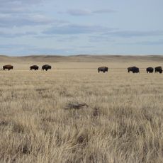
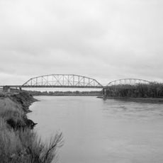
Medicine Lake Wilderness is a 11,366-acre protected landscape in northeastern Montana with rolling prairie hills and wetland depressions shaped by ancient glacial movements. The land shows clear signs of ice-age sculpting, with open grasslands and scattered water-filled basins throughout the terrain.

The area gained official protection in 1976 when it was designated as part of the National Wilderness Preservation System, one of many lands receiving this status that year. This designation ensured the landscape would remain free from roads, development, and mechanical use.

The name Medicine Lake originates from Assiniboine language, referring to the waters that fill the ancient valley shaped by glacial movements.

The area is most easily reached by turning north on Montana Highway 16 from U.S. Route 2 near Culbertson. Visitors should prepare for open terrain with few facilities nearby and weather that can change quickly across the exposed prairie.

The Sandhills section contains sand dunes reaching up to 12 meters high, sculpted by persistent northwest winds across an otherwise flat landscape. These unexpected formations resulted from sediment deposits left behind after the glaciers retreated.

The community of curious travelers

AroundUs brings together thousands of curated places, local tips, and hidden gems, enriched daily by 60,000 contributors worldwide.

Start exploring
Location
GPS coordinates
48.45000,-104.35000
Latest update
December 14, 2025 13:06
Around this place
Bakken formation
Canada

Bakken formation

104.4 km
Interior Plains
Canada

Interior Plains

126.2 km
Fort Buford
United States of America

Fort Buford

57.7 km
Four Bears Bridge
United States of America

Four Bears Bridge

142.6 km
Montana Cowboy Hall of Fame
United States of America

Montana Cowboy Hall of Fame

103.7 km
Snowden Bridge
United States of America

Snowden Bridge

53.5 km
Missouri-Yellowstone Confluence Interpretive Center
United States of America

Missouri-Yellowstone Confluence Interpretive Center

58.3 km
Fairview Lift Bridge
United States of America

Fairview Lift Bridge

64.7 km
Grassy Butte Post Office
United States of America

Grassy Butte Post Office

143.5 km
Ambrose–Torquay Border Crossing
Canada

Ambrose–Torquay Border Crossing

88.1 km
Crow Flies High State Recreation Area
United States of America

Crow Flies High State Recreation Area

143.6 km
Trossachs
Canada

Trossachs

132.6 km
Lewis and Clark Bridge
United States of America

Lewis and Clark Bridge

97.6 km
Alkabo School
United States of America

Alkabo School

57.5 km
United States of America

Lostwood Wilderness

141.8 km
Rocky Valley Lutheran Church
United States of America

Rocky Valley Lutheran Church

48.1 km
Daniels County Courthouse
United States of America

Daniels County Courthouse

87.4 km
James Memorial Library
United States of America

James Memorial Library

63.3 km
Peoples' Congregational Church
United States of America

Peoples' Congregational Church

83.1 km
Niels Nielsen Fourteen-Side Barn Farm
United States of America

Niels Nielsen Fourteen-Side Barn Farm

110.8 km
Divide County Courthouse
United States of America

Divide County Courthouse

93.3 km
Old U.S. Post Office
United States of America

Old U.S. Post Office

63.4 km
Ray Opera House
United States of America

Ray Opera House

88.2 km
Fort Union Trading Post National Historic Site
United States of America

Fort Union Trading Post National Historic Site

55.2 km
First English Free Lutheran Church (Lostwood)
United States of America

First English Free Lutheran Church (Lostwood)

142.3 km
Fort Buford State Historic Site
United States of America

Fort Buford State Historic Site

57.6 km
Columbus Theatre
United States of America

Columbus Theatre

126 km
Elkhorn Ranch State Historic Site
United States of America

Elkhorn Ranch State Historic Site

143.9 km
Show the full map
Reviews
Share your experience

No review yet

Discussions
Start a discussion...

No discussion yet

« Medicine Lake Wilderness - Protected wilderness area in northeastern Montana, United States » is provided by Around Us (aroundus.com). Images and texts are derived from Wikimedia project under a Creative Commons license. You are allowed to copy, distribute, and modify copies of this page, under the conditions set by the license, as long as this note is clearly visible.

Discover hidden gems everywhere you go!

From secret cafés to breathtaking viewpoints, skip the crowded tourist spots and find places that match your style. Our app makes it easy with voice search, smart filtering, route optimization, and insider tips from travelers worldwide. Download now for the complete mobile experience.

Around Us App Screenshot

A unique approach to discovering new places

Le Figaro

All the places worth exploring

France Info

A tailor-made excursion in just a few clicks

20 Minutes

Around Us
Travel Guide & Maps
Download

Send to your phone

QR Code
1

Open the camera app on your mobile.

2

Point at the QR code with your camera. A notification will appear.

3

Tap the notification to open the link.