Chest opened
+${chestReward.xp} XP
Explorer
NOUVEAU ×${chestReward.collectible.quantity}
tapez pour fermer
Chest locked

Open chests in the app

Around Us is built for your phone — chests unlock when you walk, explore and capture nearby places.

Enable Location

We need your location to show you interesting places around you

Discover nearby places

Find interesting locations and hidden gems around you

Precise directions

Get accurate directions and distances to places

Your location is never shared with other users. It's only used when you tap the location button.

Log in to your account

Start exploring — it's free

Trusted by 74,661 travelers worldwide

Continue with Google
Continue with Apple
or

We will send you a code to connect

By continuing, you accept our Terms and Conditions and our Privacy Policy

Check your inbox

We've sent a pincode in your inbox. Please enter the code below.

Williston Basin
Discussion Reviews Photo
15.3k Popularity

Williston Basin, Structural basin in Saskatchewan, North Dakota, and Montana.

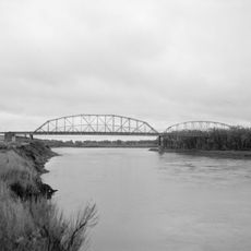
The Williston Basin is a structural depression underlying parts of Saskatchewan, North Dakota, and Montana. It holds major deposits of oil, natural gas, and potash within its layered sediments.

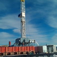
Oil was first discovered in 1951 at the Nesson Anticline by Amerada Corporation. This discovery prompted rapid development, with most potential oil areas leased within a few years.

The geological formations draw researchers and professionals from multiple institutions who study the basin's sedimentary patterns and resource distribution patterns.

The region is documented through thousands of wells that provide extensive geological data to research institutions. Scholars can examine the layers and rock formations using drill core samples and seismic surveys.

Beneath the basin lies the Trans-Hudson Orogenic Belt, whose deep structures formed around two billion years ago. These ancient geological foundations created the conditions that allowed this large depression and its resource concentrations to develop.

The community of curious travelers

AroundUs brings together thousands of curated places, local tips, and hidden gems, enriched daily by 60,000 contributors worldwide.

Start exploring
Location
Location
Location
GPS coordinates
49.00000,-104.00000
Latest update
December 7, 2025 19:31
Around this place
Bakken formation
United States of America

Bakken formation

103.1 km
Interior Plains
Canada

Interior Plains

91.5 km
Fort Buford
United States of America

Fort Buford

112.8 km
Montmartre
Canada

Montmartre

141.5 km
Claybank Brick Plant
Canada

Claybank Brick Plant

147 km
Snowden Bridge
United States of America

Snowden Bridge

111.5 km
Canada

Sedley

129.9 km
Missouri-Yellowstone Confluence Interpretive Center
United States of America

Missouri-Yellowstone Confluence Interpretive Center

113 km
Fairview Lift Bridge
United States of America

Fairview Lift Bridge

119.3 km
Des Lacs National Wildlife Refuge
United States of America

Des Lacs National Wildlife Refuge

140.4 km
Ambrose–Torquay Border Crossing
Canada

Ambrose–Torquay Border Crossing

37.5 km
Trossachs
Canada

Trossachs

73 km
Lewis and Clark Bridge
United States of America

Lewis and Clark Bridge

153.6 km
Great Northern Railway Underpass
United States of America

Great Northern Railway Underpass

140.5 km
Alkabo School
United States of America

Alkabo School

17 km
United States of America

Lostwood Wilderness

120.1 km
Portal State Bank
United States of America

Portal State Bank

106 km
Rocky Valley Lutheran Church
United States of America

Rocky Valley Lutheran Church

31.3 km
Daniels County Courthouse
United States of America

Daniels County Courthouse

106.5 km
James Memorial Library
United States of America

James Memorial Library

98.6 km
Peoples' Congregational Church
United States of America

Peoples' Congregational Church

143.6 km
Niels Nielsen Fourteen-Side Barn Farm
United States of America

Niels Nielsen Fourteen-Side Barn Farm

78.4 km
Divide County Courthouse
United States of America

Divide County Courthouse

52.5 km
Old U.S. Post Office
United States of America

Old U.S. Post Office

98.9 km
Ray Opera House
United States of America

Ray Opera House

95.3 km
Mountrail County Courthouse
United States of America

Mountrail County Courthouse

140.4 km
Fort Union Trading Post National Historic Site
United States of America

Fort Union Trading Post National Historic Site

111.4 km
First English Free Lutheran Church (Lostwood)
United States of America

First English Free Lutheran Church (Lostwood)

129.6 km
Show the full map
Reviews
Share your experience

No review yet

Discussions
Start a discussion...

No discussion yet

« Williston Basin - Structural basin in Saskatchewan, North Dakota, and Montana » is provided by Around Us (aroundus.com). Images and texts are derived from Wikimedia project under a Creative Commons license. You are allowed to copy, distribute, and modify copies of this page, under the conditions set by the license, as long as this note is clearly visible.

Discover hidden gems everywhere you go!

From secret cafés to breathtaking viewpoints, skip the crowded tourist spots and find places that match your style. Our app makes it easy with voice search, smart filtering, route optimization, and insider tips from travelers worldwide. Download now for the complete mobile experience.

Around Us App Screenshot

A unique approach to discovering new places

Le Figaro

All the places worth exploring

France Info

A tailor-made excursion in just a few clicks

20 Minutes

Around Us
Travel Guide & Maps
Download

Send to your phone

QR Code
1

Open the camera app on your mobile.

2

Point at the QR code with your camera. A notification will appear.

3

Tap the notification to open the link.