Chest opened
+${chestReward.xp} XP
Explorer
NOUVEAU ×${chestReward.collectible.quantity}
tapez pour fermer
Chest locked

Open chests in the app

Around Us is built for your phone — chests unlock when you walk, explore and capture nearby places.

Enable Location

We need your location to show you interesting places around you

Discover nearby places

Find interesting locations and hidden gems around you

Precise directions

Get accurate directions and distances to places

Your location is never shared with other users. It's only used when you tap the location button.

North Canadian River

Log in to your account

Start exploring — it's free

Trusted by 72,979 travelers worldwide

Continue with Google
Continue with Apple
or

We will send you a code to connect

By continuing, you accept our Terms and Conditions and our Privacy Policy

Check your inbox

We've sent a pincode in your inbox. Please enter the code below.

North Canadian River
Discussion Reviews 1 Photos
14.4k Popularity

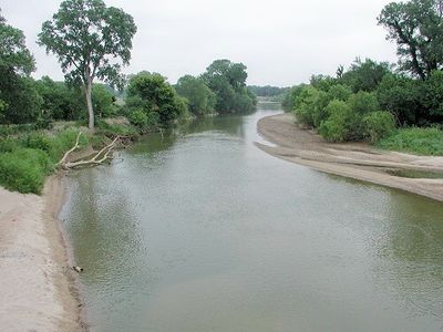
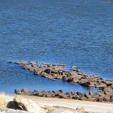
North Canadian River, Major river in Oklahoma, United States

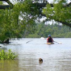
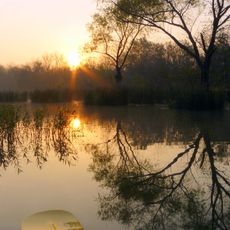
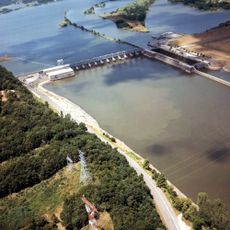
The North Canadian River is a waterway flowing through Oklahoma that begins where Beaver River and Wolf Creek merge in Woodward County. In Oklahoma City, a system of locks creates small lakes that support rowing, kayaking, and water sports activities.

The river held significance for Native peoples long before federal authorities formally classified it in the early 20th century. Over time, it became essential to water supply systems serving the surrounding region.

The Muscogee Creek Nation calls this waterway Oktahutchee, reflecting their deep connection to it. Local communities gather along its banks for fishing and relaxation throughout the year.

Visit during warmer months when water activities are most accessible and enjoyable. Wear comfortable shoes and bring water-resistant clothing, especially if you plan to explore the shoreline.

The river feeds multiple reservoirs that supply water to Oklahoma City and surrounding communities, making it a hidden backbone of urban infrastructure. Few visitors realize how essential this source is to the everyday water needs of millions.

The community of curious travelers

AroundUs brings together thousands of curated places, local tips, and hidden gems, enriched daily by 60,000 contributors worldwide.

Start exploring
Location
GPS coordinates
35.37500,-95.61000
Latest update
December 7, 2025 20:21
Around this place
Eufaula Lake
United States of America

Eufaula Lake

12.8 km
Arrowhead State Park
United States of America

Arrowhead State Park

23.5 km
Creek National Capitol
United States of America

Creek National Capitol

42.9 km
Five Civilized Tribes Museum
United States of America

Five Civilized Tribes Museum

46.8 km
Lake Eufaula State Park
United States of America

Lake Eufaula State Park

3.3 km
Deep Fork National Wildlife Refuge
United States of America

Deep Fork National Wildlife Refuge

39.8 km
Webbers Falls Lake
United States of America

Webbers Falls Lake

41.1 km
Eastside Baptist Church
United States of America

Eastside Baptist Church

42.1 km
Manhattan Building
United States of America

Manhattan Building

46.9 km
Oklahoma Odd Fellows Home at Checotah
United States of America

Oklahoma Odd Fellows Home at Checotah

14.2 km
Severs Hotel
United States of America

Severs Hotel

46.9 km
A.W. Patterson House
United States of America

A.W. Patterson House

46.8 km
Grant Foreman House
United States of America

Grant Foreman House

46.7 km
First Baptist Central Church
United States of America

First Baptist Central Church

43 km
St. Anthony's Catholic Church
United States of America

St. Anthony's Catholic Church

42.6 km
Surety Building
United States of America

Surety Building

46.9 km
Railway Exchange Building
United States of America

Railway Exchange Building

47.1 km
St. Thomas Primitive Baptist Church
United States of America

St. Thomas Primitive Baptist Church

36.8 km
A. C. Trumbo House
United States of America

A. C. Trumbo House

46.9 km
River Country Water Park
United States of America

River Country Water Park

45.4 km
V. R. Coss House
United States of America

V. R. Coss House

46.8 km
Ed Edmondson United States Courthouse
United States of America

Ed Edmondson United States Courthouse

46.8 km
Kinta High School
United States of America

Kinta High School

45 km
United States of America

Hotel Muskogee

47 km
Okmulgee Downtown Historic District
United States of America

Okmulgee Downtown Historic District

42.7 km
First United Methodist Church
United States of America

First United Methodist Church

13.2 km
Oklahoma Music Hall of Fame
United States of America

Oklahoma Music Hall of Fame

46.5 km
Lake Eufala Dam ORV Area
United States of America

Lake Eufala Dam ORV Area

24.7 km
Show the full map
Reviews
Share your experience

No review yet

Discussions
Start a discussion...

No discussion yet

« North Canadian River - Major river in Oklahoma, United States » is provided by Around Us (aroundus.com). Images and texts are derived from Wikimedia project under a Creative Commons license. You are allowed to copy, distribute, and modify copies of this page, under the conditions set by the license, as long as this note is clearly visible.

Discover hidden gems everywhere you go!

From secret cafés to breathtaking viewpoints, skip the crowded tourist spots and find places that match your style. Our app makes it easy with voice search, smart filtering, route optimization, and insider tips from travelers worldwide. Download now for the complete mobile experience.

Around Us App Screenshot

A unique approach to discovering new places

Le Figaro

All the places worth exploring

France Info

A tailor-made excursion in just a few clicks

20 Minutes

Around Us
Travel Guide & Maps
Download

Send to your phone

QR Code
1

Open the camera app on your mobile.

2

Point at the QR code with your camera. A notification will appear.

3

Tap the notification to open the link.