Chest opened
+${chestReward.xp} XP
Explorer
NOUVEAU ×${chestReward.collectible.quantity}
tapez pour fermer
Chest locked

Open chests in the app

Around Us is built for your phone — chests unlock when you walk, explore and capture nearby places.

Enable Location

We need your location to show you interesting places around you

Discover nearby places

Find interesting locations and hidden gems around you

Precise directions

Get accurate directions and distances to places

Your location is never shared with other users. It's only used when you tap the location button.

Log in to your account

Start exploring — it's free

Trusted by 72,879 travelers worldwide

Continue with Google
Continue with Apple
or

We will send you a code to connect

By continuing, you accept our Terms and Conditions and our Privacy Policy

Check your inbox

We've sent a pincode in your inbox. Please enter the code below.

Discussion Reviews Photo
3.1k Popularity

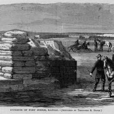
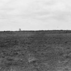
Cimarron Redoubt, Military redoubt in Center Township, Kansas, United States.

The Cimarron Redoubt is a military fortification in Center Township, Kansas, with square walls measuring about 60 feet on each side. These walls are built from sandbags and rise about 2 to 3 feet above the surrounding ground.

The fort was built in 1870 during the Comanche War to protect travelers and settlers using the transportation route between Fort Supply and Fort Dodge. It served as a defensive position during a period of significant conflict in the region.

The redoubt later transformed from a military post into a store and the Deep Hole post office, marking the transition from conflict to civilian life.

The location can be found using coordinates 37.029972, -99.763194, and the site is surrounded by tall grass. The natural grass coverage helps protect the structure from further weathering and makes it less immediately visible from a distance.

This is the only documented sandbag fort in Kansas and has maintained its original form through strategic log reinforcements. This unusual construction method with sandbags sets it apart from the typical stone fort designs of that era.

The community of curious travelers

AroundUs brings together thousands of curated places, local tips, and hidden gems, enriched daily by 60,000 contributors worldwide.

Start exploring
Location
Inception
1870
GPS coordinates
37.02997,-99.76319
Latest update
December 12, 2025 09:07
Around this place
Long Branch Saloon
United States of America

Long Branch Saloon

83.5 km
Big Well
United States of America

Big Well

76.4 km
Alabaster Caverns State Park
United States of America

Alabaster Caverns State Park

66.2 km
Boiling Springs State Park
United States of America

Boiling Springs State Park

76.2 km
Brenham
United States of America

Brenham

81.3 km
Dalton Gang Hideout and Museum
United States of America

Dalton Gang Hideout and Museum

58 km
Big Basin Prairie Preserve
United States of America

Big Basin Prairie Preserve

31.3 km
Fort Dodge
United States of America

Fort Dodge

79.5 km
Santa Fe Trail Remains
United States of America

Santa Fe Trail Remains

93.1 km
Fort Supply
United States of America

Fort Supply

53.6 km
Cathedral of Our Lady of Guadalupe
United States of America

Cathedral of Our Lady of Guadalupe

88.2 km
Fromme-Birney Round Barn
United States of America

Fromme-Birney Round Barn

59.7 km
Sacred Heart Cathedral
United States of America

Sacred Heart Cathedral

83.9 km
Dodge City Public Library
United States of America

Dodge City Public Library

83.8 km
Immaculate Heart of Mary Catholic Church
United States of America

Immaculate Heart of Mary Catholic Church

84.7 km
L. L. Stine House
United States of America

L. L. Stine House

73.8 km
Fowler Swimming Pool and Bathhouse
United States of America

Fowler Swimming Pool and Bathhouse

54.8 km
Protection High School
United States of America

Protection High School

31.3 km
Stockgrowers State Bank
United States of America

Stockgrowers State Bank

17.7 km
Stein House
United States of America

Stein House

18 km
Girl Scout Little House
United States of America

Girl Scout Little House

17.9 km
Ashland Grade School
United States of America

Ashland Grade School

17.8 km
Harper County Courthouse
United States of America

Harper County Courthouse

25 km
Long Branch Lagoon
United States of America

Long Branch Lagoon

83.4 km
Comanche County Courthouse
United States of America

Comanche County Courthouse

47 km
The Artesian Beach
United States of America

The Artesian Beach

78.9 km
Home of Stone
United States of America

Home of Stone

83.8 km
Kiowa County Historical Museum and Soda Fountain
United States of America

Kiowa County Historical Museum and Soda Fountain

76.2 km
Show the full map
Reviews
Share your experience

No review yet

Discussions
Start a discussion...

No discussion yet

« Cimarron Redoubt - Military redoubt in Center Township, Kansas, United States » is provided by Around Us (aroundus.com). Images and texts are derived from Wikimedia project under a Creative Commons license. You are allowed to copy, distribute, and modify copies of this page, under the conditions set by the license, as long as this note is clearly visible.

Discover hidden gems everywhere you go!

From secret cafés to breathtaking viewpoints, skip the crowded tourist spots and find places that match your style. Our app makes it easy with voice search, smart filtering, route optimization, and insider tips from travelers worldwide. Download now for the complete mobile experience.

Around Us App Screenshot

A unique approach to discovering new places

Le Figaro

All the places worth exploring

France Info

A tailor-made excursion in just a few clicks

20 Minutes

Around Us
Travel Guide & Maps
Download

Send to your phone

QR Code
1

Open the camera app on your mobile.

2

Point at the QR code with your camera. A notification will appear.

3

Tap the notification to open the link.