Chest opened
+${chestReward.xp} XP
Explorer
NOUVEAU ×${chestReward.collectible.quantity}
tapez pour fermer
Chest locked

Open chests in the app

Around Us is built for your phone — chests unlock when you walk, explore and capture nearby places.

Enable Location

We need your location to show you interesting places around you

Discover nearby places

Find interesting locations and hidden gems around you

Precise directions

Get accurate directions and distances to places

Your location is never shared with other users. It's only used when you tap the location button.

Log in to your account

Start exploring — it's free

Trusted by 73,006 travelers worldwide

Continue with Google
Continue with Apple
or

We will send you a code to connect

By continuing, you accept our Terms and Conditions and our Privacy Policy

Check your inbox

We've sent a pincode in your inbox. Please enter the code below.

Fort Cobb Reservoir
Discussion Reviews Photo
3.7k Popularity

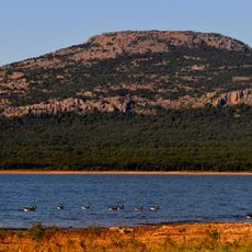
Fort Cobb Reservoir, body of water

Fort Cobb Reservoir is a large lake in Oklahoma with a shoreline stretching about 36 miles and covering over 4000 acres. The water reaches depths of up to 50 feet (15 meters) in some places and offers space for fishing, boating, and swimming.

The reservoir was built many years ago to control water flow and supply water to nearby areas. Over time it has grown into a popular spot for recreation and remains an important part of regional water management today.

The area has several boat ramps, fishing jetties, and campgrounds with full hookups around the water. Visitors should use the simple roads that are accessible year-round and visit local bait shops for gear and supplies.

The lake is managed by multiple agencies including the Bureau of Reclamation and US Army Corps of Engineers to maintain a healthy ecosystem. Depth maps show where fish hide and help anglers locate the best fishing spots.

The community of curious travelers

AroundUs brings together thousands of curated places, local tips, and hidden gems, enriched daily by 60,000 contributors worldwide.

Start exploring
Location
GPS coordinates
35.20000,-98.48333
Latest update
February 7, 2026 11:40
Around this place
Fort Sill
United States of America

Fort Sill

55.2 km
Mount Scott
United States of America

Mount Scott

50.9 km
Wichita Mountains Wildlife Refuge
United States of America

Wichita Mountains Wildlife Refuge

52.1 km
University of Science and Arts of Oklahoma
United States of America

University of Science and Arts of Oklahoma

51.7 km
Fort Reno
United States of America

Fort Reno

57.2 km
Lake Lawtonka
United States of America

Lake Lawtonka

49.5 km
Stafford Air & Space Museum
United States of America

Stafford Air & Space Museum

41.9 km
Signal Mountain Blockhouse
United States of America

Signal Mountain Blockhouse

58.5 km
United States of America

Fort Cobb

11.9 km
El Reno High School
United States of America

El Reno High School

60.5 km
Red Rock Canyon State Park
United States of America

Red Rock Canyon State Park

30.2 km
Darlington Agency
United States of America

Darlington Agency

60 km
Rock Mary
United States of America

Rock Mary

29.4 km
United States of America

Charon's Garden Wilderness Area

57.9 km
Southern Plains Indian Museum
United States of America

Southern Plains Indian Museum

26.9 km
Oklahoma Route 66 Museum
United States of America

Oklahoma Route 66 Museum

57 km
El Reno Municipal Swimming Pool Bath House
United States of America

El Reno Municipal Swimming Pool Bath House

59.4 km
Washita County Courthouse
United States of America

Washita County Courthouse

47.1 km
Water-Zoo Clinton Indoor Water Park
United States of America

Water-Zoo Clinton Indoor Water Park

56.1 km
First Baptist Church
United States of America

First Baptist Church

26.2 km
New Hope Baptist Church
United States of America

New Hope Baptist Church

53.4 km
Red Cross Canteen
United States of America

Red Cross Canteen

60.2 km
William I. and Magdalen M. Goff House
United States of America

William I. and Magdalen M. Goff House

60.3 km
Cordell Carnegie Public Library
United States of America

Cordell Carnegie Public Library

47.1 km
Richardson Building
United States of America

Richardson Building

54.1 km
Verden Separate School
United States of America

Verden Separate School

53.4 km
Hobart City Hall
United States of America

Hobart City Hall

58.8 km
Holy City of the Wichitas Historic District
United States of America

Holy City of the Wichitas Historic District

51.8 km
Show the full map
Reviews
Share your experience

No review yet

Discussions
Start a discussion...

No discussion yet

« Fort Cobb Reservoir - body of water » is provided by Around Us (aroundus.com). Images and texts are derived from Wikimedia project under a Creative Commons license. You are allowed to copy, distribute, and modify copies of this page, under the conditions set by the license, as long as this note is clearly visible.

Discover hidden gems everywhere you go!

From secret cafés to breathtaking viewpoints, skip the crowded tourist spots and find places that match your style. Our app makes it easy with voice search, smart filtering, route optimization, and insider tips from travelers worldwide. Download now for the complete mobile experience.

Around Us App Screenshot

A unique approach to discovering new places

Le Figaro

All the places worth exploring

France Info

A tailor-made excursion in just a few clicks

20 Minutes

Around Us
Travel Guide & Maps
Download

Send to your phone

QR Code
1

Open the camera app on your mobile.

2

Point at the QR code with your camera. A notification will appear.

3

Tap the notification to open the link.