Franco-Brazilian Binational Bridge, International bridge between Saint-Georges, French Guiana and Oiapoque, Brazil
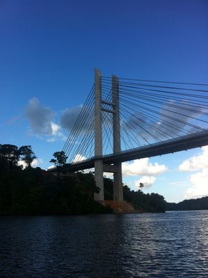
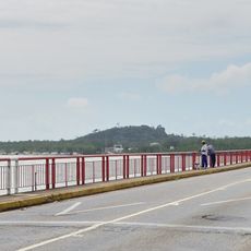
The Franco-Brazilian Binational Bridge is a cable-stayed structure that crosses the Oyapock River and connects the two border cities. The roadway provides separate lanes for vehicles and a dedicated pedestrian pathway on one side.
Construction finished in 2011, but the bridge did not open officially until 2017 due to administrative and infrastructure requirements. This delayed opening marked the final shift from ferry-based to fixed land crossing at this border.
This bridge marks the first permanent land crossing between Brazil and France, replacing the ferry system that once connected the two river banks. It has transformed how people in both towns interact and conduct daily business across the border.
Both pedestrians and drivers can cross the border during daylight hours, and travelers should expect standard document checks. The separated pathways for walkers and vehicles make the crossing safe and straightforward.
The structure was designed with about 15 meters of vertical clearance underneath to allow river vessels to continue using their traditional navigation routes. This thoughtful design preserved river traffic that had existed long before the bridge was built.
Location: Saint-Georges
Location: Oiapoque
Inception: March 2017
Height: 83 m
Length: 378 m
Part of: Brazil–France border
GPS coordinates: 3.85690,-51.82561
Latest update: December 8, 2025 19:54
Camp Crique Anguille
132.6 km
Cabo Orange National Park
72.8 km
Kaw-Roura Marshes National Nature Reserve
89.8 km
Habitation Loyola
126.1 km
Pont du Larivot
131.5 km
Jardin botanique de Cayenne
132.4 km
Fort Diamant
122.2 km
Salines de Montjoly
128.8 km
Montagne d'Argent
61.3 km
Réserve naturelle nationale de l'île du Grand Connétable
108.7 km
Monte Carupina
46.4 km
Trésor Regional Nature Reserve
97.8 km
La Trinité National Nature Reserve
84.5 km
Habitation Vidal
123.9 km
Réserve naturelle nationale du mont Grand Matoury
126.7 km
Windmill of Remire-Montjoly
125.7 km
Serpent de Pascaud
122.2 km
Église Saint-Dominique de Roura
111.6 km
Plage de Gosselin
124.4 km
Roches gravées de la Montagne Favard
75.9 km
Plage Bourda
130.1 km
Église Sainte-Thérèse de Montjoly
127.4 km
Église Saint-Étienne de Régina
61 km
Église Hmong de Cacao
107.3 km
Canal de Kaw
75.3 km
Sentier Molokoï
106.2 km
Saut Maripa (busay)
9 km
Marais de Kaw
91.6 kmVisited this place? Tap the stars to rate it and share your experience / photos with the community! Try now! You can cancel it anytime.
Discover hidden gems everywhere you go!
From secret cafés to breathtaking viewpoints, skip the crowded tourist spots and find places that match your style. Our app makes it easy with voice search, smart filtering, route optimization, and insider tips from travelers worldwide. Download now for the complete mobile experience.
A unique approach to discovering new places❞
— Le Figaro
All the places worth exploring❞
— France Info
A tailor-made excursion in just a few clicks❞
— 20 Minutes