Chest opened
+${chestReward.xp} XP
Explorer
NOUVEAU ×${chestReward.collectible.quantity}
tapez pour fermer

See the monuments around you in AR Open chests in the app

Around Us is built for your phone — point your camera at the streets and discover the monuments and places around you in augmented reality. Around Us is built for your phone — chests unlock when you walk, explore and capture nearby places.

•

Enable Location

We need your location to show you interesting places around you

Discover nearby places

Find interesting locations and hidden gems around you

Precise directions

Get accurate directions and distances to places

Your location is never shared with other users. It's only used when you tap the location button.

Log in to your account

Start exploring — it's free

Trusted by 92,812 travelers worldwide

Continue with Google
Continue with Apple
or

We will send you a code to connect

By continuing, you accept our Terms and Conditions and our Privacy Policy

Check your inbox

We've sent a pincode in your inbox. Please enter the code below.

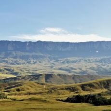
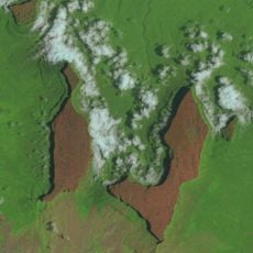
Brazil–Guyana border, International land boundary between Brazil and Guyana, South America.

The Brazil–Guyana border is a 1,605.8 km line, of which 698.2 km follow rivers and channels and over 907.6 km follow watershed divides. It begins at the triple point on Mount Roraima, passes Mount Caburaí — Brazil's northernmost point — and ends at the Suriname triple border. The main crossing is the Takutu River bridge between Lethem and Bonfim.

The 1904 arbitration by King Victor Emmanuel III of Italy divided the disputed Pirara region, awarding 13,570 km² to Brazil and 19,630 km² to Britain. A slight modification on 22 April 1926, correcting the source of the Cotingo River, gave the boundary its present alignment. The Joint Brazil–Guyana Boundary Commission has since placed 134 markers, installed between 1932 and 1939.

The border cuts through the territory of the Macuxi, Pemon, Wapishana and Kapon peoples, whose communities sit on both sides of the line. In the early 20th century some Amerindians moved into Guyana, where cattle ranching paid better wages than in the Branco basin; after independence in 1966 the flow reversed toward Brazil.

This border region is remote and requires careful preparation for any visit or crossing. Visitors should check current conditions at crossing points and gather local information before planning to travel through the area.

The Joint Brazil–Guyana Boundary Commission has placed 134 markers along the line, 89 of them on the watershed stretch between the Amazon basin and the Essequibo and Courantyne basins. The easternmost section, south of the Tacutu River, is where Lethem and Bonfim face each other across the Takutu Bridge, linking Boa Vista with Georgetown.

The community of curious travelers

AroundUs brings together thousands of curated places, local tips, and hidden gems, enriched daily by 92,812 contributors worldwide.
Start exploring
Length
1,606 km
Part of
borders of Guyana, borders of Brazil
GPS coordinates
5.20139,-60.73472
Latest update
October 25, 2026 22:51
Reviews
Share your experience

No review yet

Discussions
Start a discussion...

No discussion yet

« Brazil–Guyana border - International land boundary between Brazil and Guyana, South America » is provided by Around Us (aroundus.com). Images and texts are derived from Wikimedia project under a Creative Commons license. You are allowed to copy, distribute, and modify copies of this page, under the conditions set by the license, as long as this note is clearly visible.

Discover hidden gems everywhere you go!

From secret cafés to breathtaking viewpoints, skip the crowded tourist spots and find places that match your style. Our app makes it easy with voice search, smart filtering, route optimization, and insider tips from travelers worldwide. Download now for the complete mobile experience.

Around Us App Screenshot
❝

A unique approach to discovering new places❞

— Le Figaro

❝

All the places worth exploring❞

— France Info

❝

A tailor-made excursion in just a few clicks❞

— 20 Minutes

Around Us
Travel Guide & Maps
Download

Send to your phone

QR Code
1

Open the camera app on your mobile.

2

Point at the QR code with your camera. A notification will appear.

3

Tap the notification to open the link.