Sakornia, Summit in Guria, Georgia
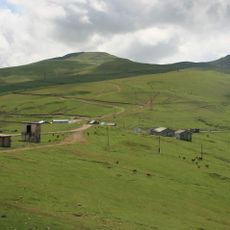
Sakornia is a 2752-metre mountain on a northern spur of the Meskheti Range, on the watershed between the upper reaches of the Bakhvis Tskali and Natanebi rivers. Its summit is flat, and its northern and north-eastern slopes are sharply cut and craggy. The mountain is built of Middle Eocene coarse-grained tuff-breccias and tuffs, bears traces of Quaternary glaciation and is covered with subalpine and alpine vegetation.
Sakornia is built from Middle Eocene coarse-grained tuff-breccias and tuffs, the material that forms its massif. Its flat summit and the sharply dissected, cliff-like northern and north-eastern slopes show traces of Quaternary glaciation. The mountain is covered by subalpine and alpine vegetation.
Local inhabitants of the Guria region maintain traditional practices of seasonal grazing and agricultural activities on the lower slopes of Sakornia.
The sources give no marked trail or access route to the summit; the flat top is reached across the sharply broken, cliff-like northern and northeastern slopes. The mountain lies on the watershed of the upper Bakhvis Tskali and Natanebi rivers, so approach from those valleys. Snow and ice traces from Quaternary glaciation remain on the slopes.
The sources disagree on which municipality holds the summit: the Georgian article places it in Ozurgeti Municipality, while the English article puts it in Chokhatauri Municipality, Guria. The peak is built of Middle Eocene coarse-grained tuff-breccias and tuffs, and traces of Quaternary glaciation are visible on its slopes.
The community of curious travelers
AroundUs brings together thousands of curated places, local tips, and hidden gems, enriched daily by 94,086 contributors worldwide.