Chest opened
+${chestReward.xp} XP
Explorer
NOUVEAU ×${chestReward.collectible.quantity}
tapez pour fermer
Chest locked

Open chests in the app

Around Us is built for your phone — chests unlock when you walk, explore and capture nearby places.

Enable Location

We need your location to show you interesting places around you

Discover nearby places

Find interesting locations and hidden gems around you

Precise directions

Get accurate directions and distances to places

Your location is never shared with other users. It's only used when you tap the location button.

M-2 motorway

Log in to your account

Start exploring — it's free

Trusted by 72,878 travelers worldwide

Continue with Google
Continue with Apple
or

We will send you a code to connect

By continuing, you accept our Terms and Conditions and our Privacy Policy

Check your inbox

We've sent a pincode in your inbox. Please enter the code below.

M-2 motorway
Discussion Reviews 1 Photos
16.7k Popularity

M-2 motorway, motorway in Pakistan

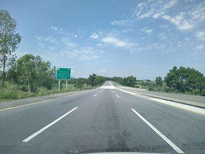
The M-2 motorway is a long-distance highway connecting Lahore to Islamabad through Punjab province. It features six lanes and passes through diverse terrain including fields, the Salt Range mountains, river crossings, and towns like Sheikhupura and Kallar Kahar.

Construction began in the early 1990s and the motorway opened to the public in 1997, making it the first long-distance motorway in South Asia. The project was part of Pakistan's infrastructure modernization efforts and involved international companies.

The motorway's name comes from Pakistan's official highway numbering system. It functions as a symbol of the country's development, as people recognize it for connecting two major cities and enabling the daily movement of workers, traders, and families between them.

Service areas are located roughly every 60 to 70 kilometers along the route, offering fuel, food, restrooms, and rest spaces for travelers. Speed limits are strictly enforced, and portions of the road are illuminated at night to help with safe driving.

The Salt Range viaduct is one of the highest bridges in the region, with tall thick pillars that travelers often notice and photograph as they pass. This section was upgraded in 2006 with improved signage and road markings for better safety.

The community of curious travelers

AroundUs brings together thousands of curated places, local tips, and hidden gems, enriched daily by 60,000 contributors worldwide.

Start exploring
Location
Inception
1997
Part of
AH1, AH4
GPS coordinates
31.53861,74.26167
Latest update
February 17, 2026 01:40
Reviews
Share your experience

No review yet

Discussions
Start a discussion...

No discussion yet

« M-2 motorway - motorway in Pakistan » is provided by Around Us (aroundus.com). Images and texts are derived from Wikimedia project under a Creative Commons license. You are allowed to copy, distribute, and modify copies of this page, under the conditions set by the license, as long as this note is clearly visible.

Discover hidden gems everywhere you go!

From secret cafés to breathtaking viewpoints, skip the crowded tourist spots and find places that match your style. Our app makes it easy with voice search, smart filtering, route optimization, and insider tips from travelers worldwide. Download now for the complete mobile experience.

Around Us App Screenshot

A unique approach to discovering new places

Le Figaro

All the places worth exploring

France Info

A tailor-made excursion in just a few clicks

20 Minutes

Around Us
Travel Guide & Maps
Download

Send to your phone

QR Code
1

Open the camera app on your mobile.

2

Point at the QR code with your camera. A notification will appear.

3

Tap the notification to open the link.