Enable Location

We need your location to show you interesting places around you

Discover nearby places

Find interesting locations and hidden gems around you

Precise directions

Get accurate directions and distances to places

Your location is never shared with other users. It's only used when you tap the location button.

Stanovoy Highlands

Log in to your account

Start exploring — it's free

Trusted by 67,585 travelers worldwide

Continue with Google
Continue with Apple
or

We will send you a code to connect

By continuing, you accept our Terms and Conditions and our Privacy Policy

Check your inbox

We've sent a pincode in your inbox. Please enter the code below.

Stanovoy Highlands
Discussion Reviews 1 Photos
12.3k Popularity

Stanovoy Highlands, Mountain range in Transbaikal region, Russia.

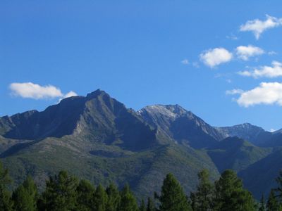
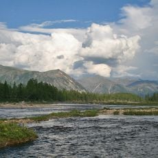
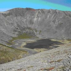
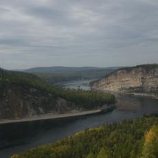
The Stanovoy Highlands form a mountain system in eastern Siberia composed of several distinct ranges including Kodar, Udokan, and Kalar. The terrain features peaks over 3000 meters alongside intermontane basins ranging from 500 to 1000 meters in elevation.

The highlands formed during major geological upheavals that shaped eastern Siberia and created the distinct mountain chains visible today. These ancient processes left the region with the complex topography that travelers encounter now.

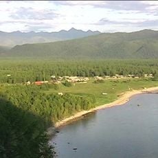
Indigenous groups of the Transbaikal region have shaped life in these mountains through herding reindeer and hunting, practices that remain visible in the valleys and grasslands today. Their presence continues to influence how the land is used and valued.

The area experiences extreme cold throughout winter months, requiring heavy-duty gear and careful preparation before entering. Visitors should allow time to acclimate and plan journeys with local expertise in mind.

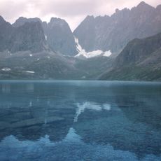
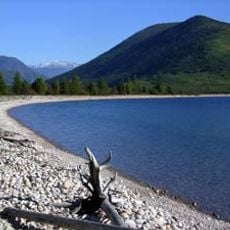
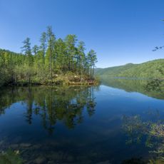
Vast peatlands and wetlands spread across the highlands despite the high elevation, supporting plants and animals adapted to harsh conditions. These environments create a surprising landscape in areas one might expect to be simply barren and rocky.

The community of curious travelers

AroundUs brings together thousands of curated places, local tips, and hidden gems, enriched daily by 60,000 contributors worldwide.

Start exploring
Location
Location
Elevation above the sea
3,072 m
GPS coordinates
56.87100,117.58200
Latest update
December 7, 2025 20:45
Around this place
Barguzin Nature Reserve
Russian Federation

Barguzin Nature Reserve

591.8 km
Patomskiy crater
Russian Federation

Patomskiy crater

275 km
Chara Sands
Russian Federation

Chara Sands

34.7 km
Devil's Bridge
Russian Federation

Devil's Bridge

267.3 km
Highland of Aldan
Russian Federation

Highland of Aldan

461.6 km
Olyokma Nature Reserve
Russian Federation

Olyokma Nature Reserve

341.3 km
Vitim Nature Reserve
Russian Federation

Vitim Nature Reserve

59.7 km
Chitinsky Datsan
Russian Federation

Chitinsky Datsan

597.2 km
Dzherginsky Nature Reserve
Russian Federation

Dzherginsky Nature Reserve

428.3 km
Pik BAM
Russian Federation

Pik BAM

808 m
Kodar National Park
Russian Federation

Kodar National Park

2.5 km
Russian Federation

Сиреневый Камень

186.4 km
Russian Federation

Aku Volcano

77.5 km
Udokan Plateau
Russian Federation

Udokan Plateau

66.8 km
Troitsky monastery
Russian Federation

Troitsky monastery

577.1 km
Lenskiye Shchyoki
Russian Federation

Lenskiye Shchyoki

446.2 km
Frolikha Adventure Coastline Track
Russian Federation

Frolikha Adventure Coastline Track

509.9 km
Памятник воинам-землякам, погибшим в годы Великой Отечественной войны (Томмот)
Russian Federation

Памятник воинам-землякам, погибшим в годы Великой Отечественной войны (Томмот)

564 km
Mamakan Reservoir
Russian Federation

Mamakan Reservoir

237.4 km
Ayachi, Amur Oblast
Russian Federation

Ayachi, Amur Oblast

404 km
Lensk war memorial
Russian Federation

Lensk war memorial

454.4 km
Текан (Амурська область)
Russian Federation

Текан (Амурська область)

411.5 km
Мемориал Славы (Нерюнгри)
Russian Federation

Мемориал Славы (Нерюнгри)

434.9 km
Мемориал воинской Славы (Витим)
Russian Federation

Мемориал воинской Славы (Витим)

410 km
Памятник И. Н. Кульбертинову (Олёкминск)
Russian Federation

Памятник И. Н. Кульбертинову (Олёкминск)

422.7 km
Ягодний (Амурська область)
Russian Federation

Ягодний (Амурська область)

425.9 km
Orthodox church of the New Martyrs and Confessors of Russia in Aldan
Russian Federation

Orthodox church of the New Martyrs and Confessors of Russia in Aldan

502.3 km
Road bridge over Aldan River in Tommot
Russian Federation

Road bridge over Aldan River in Tommot

564.2 km
Show the full map
Reviews
Share your experience

No review yet

Discussions
Start a discussion...

No discussion yet

« Stanovoy Highlands - Mountain range in Transbaikal region, Russia » is provided by Around Us (aroundus.com). Images and texts are derived from Wikimedia project under a Creative Commons license. You are allowed to copy, distribute, and modify copies of this page, under the conditions set by the license, as long as this note is clearly visible.

Discover hidden gems everywhere you go!

From secret cafés to breathtaking viewpoints, skip the crowded tourist spots and find places that match your style. Our app makes it easy with voice search, smart filtering, route optimization, and insider tips from travelers worldwide. Download now for the complete mobile experience.

Around Us App Screenshot

A unique approach to discovering new places

Le Figaro

All the places worth exploring

France Info

A tailor-made excursion in just a few clicks

20 Minutes

Around Us
Travel Guide & Maps
Download

Send to your phone

QR Code
1

Open the camera app on your mobile.

2

Point at the QR code with your camera. A notification will appear.

3

Tap the notification to open the link.