Chest opened
+${chestReward.xp} XP
Explorer
NOUVEAU ×${chestReward.collectible.quantity}
tapez pour fermer
Chest locked

Open chests in the app

Around Us is built for your phone — chests unlock when you walk, explore and capture nearby places.

Enable Location

We need your location to show you interesting places around you

Discover nearby places

Find interesting locations and hidden gems around you

Precise directions

Get accurate directions and distances to places

Your location is never shared with other users. It's only used when you tap the location button.

Novaya Chara

Log in to your account

Start exploring — it's free

Trusted by 72,943 travelers worldwide

Continue with Google
Continue with Apple
or

We will send you a code to connect

By continuing, you accept our Terms and Conditions and our Privacy Policy

Check your inbox

We've sent a pincode in your inbox. Please enter the code below.

Discussion Reviews 2 Photos
20.6k Popularity

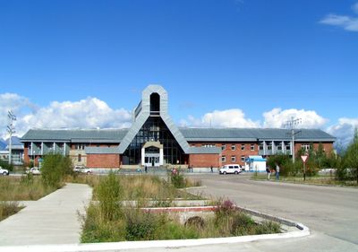
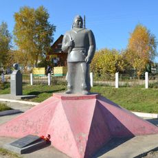
Novaya Chara, Urban settlement in Kalarsky District, Zabaykalsky Krai, Russia.

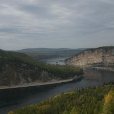
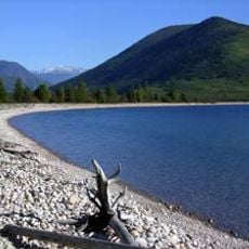
Novaya Chara is an urban settlement in eastern Siberia situated near the Chara River and surrounded by the Stanovoy mountains. The community is organized around its railway station, which forms the center of daily life and transport connections.

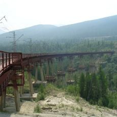
The settlement was founded in 1979 as construction crews arrived to build the Baikal-Amur Mainline, a major railway crossing eastern Siberia. Workers from the Kazakh Soviet Socialist Republic and other regions established the initial community that grew into the town we see today.

The settlement reflects the lives of railway workers who arrived from across the Soviet Union and adapted to Siberian conditions. You can see this blend in how the community is organized and how people interact with the landscape around them.

The settlement is accessible by the Baikal-Amur Mainline railway, which provides the main transport link for visitors and residents. A local airport also serves the area, and it operates on Yakutsk Time, which is useful to know when planning a visit.

The area holds significant mineral wealth beneath its surface, including Russia's largest titanium deposits and one of the world's most substantial vanadium reserves. These underground resources have shaped the economic life of the region since its founding.

The community of curious travelers

AroundUs brings together thousands of curated places, local tips, and hidden gems, enriched daily by 60,000 contributors worldwide.

Start exploring
Inception
1979
GPS coordinates
56.79153,118.27322
Latest update
December 7, 2025 10:05
Around this place
Patomskiy crater
Russian Federation

Patomskiy crater

294.7 km
Chara Sands
Russian Federation

Chara Sands

9.2 km
Devil's Bridge
Russian Federation

Devil's Bridge

307.1 km
Highland of Aldan
Russian Federation

Highland of Aldan

422.9 km
Olyokma Nature Reserve
Russian Federation

Olyokma Nature Reserve

314.8 km
Vitim Nature Reserve
Russian Federation

Vitim Nature Reserve

100 km
Barguzin Range
Russian Federation

Barguzin Range

545.1 km
Chitinsky Datsan
Russian Federation

Chitinsky Datsan

610.7 km
Dzherginsky Nature Reserve
Russian Federation

Dzherginsky Nature Reserve

463.7 km
Pik BAM
Russian Federation

Pik BAM

43.2 km
Kodar National Park
Russian Federation

Kodar National Park

43.5 km
Russian Federation

Сиреневый Камень

179.1 km
Russian Federation

Aku Volcano

84.6 km
Udokan Plateau
Russian Federation

Udokan Plateau

64.8 km
Chita Zoo
Russian Federation

Chita Zoo

612.1 km
Lenskiye Shchyoki
Russian Federation

Lenskiye Shchyoki

487.2 km
Frolikha Adventure Coastline Track
Russian Federation

Frolikha Adventure Coastline Track

548.4 km
Памятник воинам-землякам, погибшим в годы Великой Отечественной войны (Томмот)
Russian Federation

Памятник воинам-землякам, погибшим в годы Великой Отечественной войны (Томмот)

531.6 km
Mamakan Reservoir
Russian Federation

Mamakan Reservoir

279 km
Lensk war memorial
Russian Federation

Lensk war memorial

477.6 km
Мемориал Славы (Нерюнгри)
Russian Federation

Мемориал Славы (Нерюнгри)

392.8 km
Мемориал воинской Славы (Витим)
Russian Federation

Мемориал воинской Славы (Витим)

446.1 km
Памятник И. Н. Кульбертинову (Олёкминск)
Russian Federation

Памятник И. Н. Кульбертинову (Олёкминск)

417.4 km
Ягодний (Амурська область)
Russian Federation

Ягодний (Амурська область)

391.8 km
Orthodox church of the New Martyrs and Confessors of Russia in Aldan
Russian Federation

Orthodox church of the New Martyrs and Confessors of Russia in Aldan

468.9 km
Road bridge over Aldan River in Tommot
Russian Federation

Road bridge over Aldan River in Tommot

531.8 km
Lensk Troyka monument
Russian Federation

Lensk Troyka monument

477.4 km
Railway bridge through Aldan river in Tommot
Russian Federation

Railway bridge through Aldan river in Tommot

531.8 km
Show the full map
Reviews
Share your experience

No review yet

Discussions
Start a discussion...

No discussion yet

« Novaya Chara - Urban settlement in Kalarsky District, Zabaykalsky Krai, Russia » is provided by Around Us (aroundus.com). Images and texts are derived from Wikimedia project under a Creative Commons license. You are allowed to copy, distribute, and modify copies of this page, under the conditions set by the license, as long as this note is clearly visible.

Discover hidden gems everywhere you go!

From secret cafés to breathtaking viewpoints, skip the crowded tourist spots and find places that match your style. Our app makes it easy with voice search, smart filtering, route optimization, and insider tips from travelers worldwide. Download now for the complete mobile experience.

Around Us App Screenshot

A unique approach to discovering new places

Le Figaro

All the places worth exploring

France Info

A tailor-made excursion in just a few clicks

20 Minutes

Around Us
Travel Guide & Maps
Download

Send to your phone

QR Code
1

Open the camera app on your mobile.

2

Point at the QR code with your camera. A notification will appear.

3

Tap the notification to open the link.