Enable Location

We need your location to show you interesting places around you

Discover nearby places

Find interesting locations and hidden gems around you

Precise directions

Get accurate directions and distances to places

Your location is never shared with other users. It's only used when you tap the location button.

Tashtagolsky District

Log in to your account

Start exploring — it's free

Trusted by 63,568 travelers worldwide

Continue with Google
Continue with Apple
or

We will send you a code to connect

By continuing, you accept our Terms and Conditions and our Privacy Policy

Check your inbox

We've sent a pincode in your inbox. Please enter the code below.

Tashtagolsky District
Discussion Reviews 1 Photos
10.9k Popularity

Tashtagolsky District, Municipal district in Kemerovo Oblast, Russia

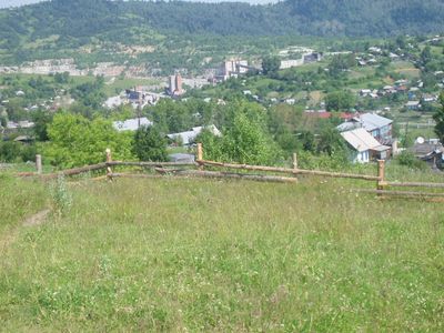
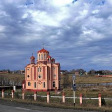
Tashtagolsky District is a municipal territory in southern Kemerovo Oblast that contains several towns and numerous rural villages spread across its land. The town of Tashtagol serves as the administrative hub for the entire district and its communities.

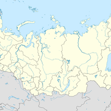
This administrative district was established in 1939 as part of Novosibirsk Oblast, then moved to Kemerovo Oblast in 1943 during a regional reorganization. The shift reflected broader changes in how Siberia's administrative boundaries were being structured at that time.

The Shors, an indigenous group native to this region, have deep roots here and their traditions remain part of the local identity. You can notice their influence in community practices and the way residents connect with the land and its history.

Visitors can best navigate the district by using Tashtagol as a reference point, since it functions as the main hub for the area. Getting around between the scattered settlements works better with private transport or local connections.

The district has experienced significant population changes since its establishment, reflecting shifts in economic and social conditions across several decades. These demographic changes tell a story about how resource-based communities in Siberia have evolved over time.

The community of curious travelers

AroundUs brings together thousands of curated places, local tips, and hidden gems, enriched daily by 60,000 contributors worldwide.

Start exploring
Location
Inception
1939
Capital city
Tashtagol
GPS coordinates
52.76667,87.86667
Latest update
December 8, 2025 13:44
Around this place
Teletskoe
Russian Federation

Teletskoe

138.1 km
Altai Nature Reserve
Russian Federation

Altai Nature Reserve

91 km
Kuznetsk Fortress
Russian Federation

Kuznetsk Fortress

121.1 km
Khakasski Nature Reserve
Russian Federation

Khakasski Nature Reserve

119 km
Shorian National Park
Russian Federation

Shorian National Park

37.5 km
Kuznetsk Metallurgists Sports Palace
Russian Federation

Kuznetsk Metallurgists Sports Palace

122.1 km
Novokuznetsk Drama Theatre
Russian Federation

Novokuznetsk Drama Theatre

120.9 km
Korbu Waterfall
Russian Federation

Korbu Waterfall

118.7 km
Transfiguration Cathedral, Novokuznetsk
Russian Federation

Transfiguration Cathedral, Novokuznetsk

120.5 km
Church of the Nativity of Jesus Christ in Novokuznetsk
Russian Federation

Church of the Nativity of Jesus Christ in Novokuznetsk

119.1 km
Salair National Park
Russian Federation

Salair National Park

127.5 km
Statue of Vladimir Mayakovsky in Novokuznetsk
Russian Federation

Statue of Vladimir Mayakovsky in Novokuznetsk

121.6 km
Iconostas cliff
Russian Federation

Iconostas cliff

76.7 km
St. John Chrysostom Church, Novokuznetsk
Russian Federation

St. John Chrysostom Church, Novokuznetsk

119 km
Ilyinsky bridge
Russian Federation

Ilyinsky bridge

131.1 km
Metallurgists' Garden
Russian Federation

Metallurgists' Garden

120.8 km
Musée ethnographique régional de Novokouznetski
Russian Federation

Musée ethnographique régional de Novokouznetski

121.4 km
Metallurg Stadium, Novokuznetsk
Russian Federation

Metallurg Stadium, Novokuznetsk

122 km
Kommunar Cinema, Novokuznetsk
Russian Federation

Kommunar Cinema, Novokuznetsk

120.7 km
Кузнецкий мост (Новокузнецк)
Russian Federation

Кузнецкий мост (Новокузнецк)

120 km
Novokuznetsk Art Museum
Russian Federation

Novokuznetsk Art Museum

120.1 km
Большая Кольтайга
Russian Federation

Большая Кольтайга

82.5 km
Байдаевский мост
Russian Federation

Байдаевский мост

118.3 km
Սուրբ Գրիգոր Լուսավորիչ եկեղեցի (Սոսնովկա)
Russian Federation

Սուրբ Գրիգոր Լուսավորիչ եկեղեցի (Սոսնովկա)

110.9 km
Здание уездного училища (Новокузнецк)
Russian Federation

Здание уездного училища (Новокузнецк)

120.3 km
527 km
Russian Federation

527 km

30.2 km
Saylyugemsky National Park
Russian Federation

Saylyugemsky National Park

53.5 km
Аквапарк "Лагуна"
Russian Federation

Аквапарк "Лагуна"

121.6 km
Show the full map
Reviews
Share your experience

No review yet

Discussions
Start a discussion...

No discussion yet

« Tashtagolsky District - Municipal district in Kemerovo Oblast, Russia » is provided by Around Us (aroundus.com). Images and texts are derived from Wikimedia project under a Creative Commons license. You are allowed to copy, distribute, and modify copies of this page, under the conditions set by the license, as long as this note is clearly visible.

Discover hidden gems everywhere you go!

From secret cafés to breathtaking viewpoints, skip the crowded tourist spots and find places that match your style. Our app makes it easy with voice search, smart filtering, route optimization, and insider tips from travelers worldwide. Download now for the complete mobile experience.

Around Us App Screenshot

A unique approach to discovering new places

Le Figaro

All the places worth exploring

France Info

A tailor-made excursion in just a few clicks

20 Minutes

Around Us
Travel Guide & Maps
Download

Send to your phone

QR Code
1

Open the camera app on your mobile.

2

Point at the QR code with your camera. A notification will appear.

3

Tap the notification to open the link.