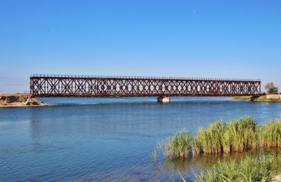
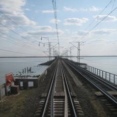
Iron Bridge, Railway bridge in Henichesk Raion, Ukraine.
The Iron Bridge is a railway bridge in Henichesk Raion that connects mainland Ukraine to the Arabat Spit across the Tonky Strait. The structure consists of metal framework designed to support rail traffic between the two regions.
Design and construction began during World War I in 1915, though the official opening did not occur until 1951. The decades between start and completion reflect the challenges faced during the project's extended timeline.
The bridge represents an engineering achievement where workers assembled its metal components mid-air without additional support structures.
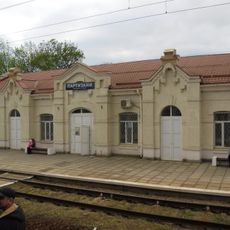
The bridge is accessible year-round and used regularly by trains and local visitors, particularly fishermen and travelers. Visitors should note this is primarily a working railway bridge where train schedules take priority.
The structure uses the Waagner-Roth system, employing bolts and screws instead of welding to allow rapid assembly without temporary supports. This construction method was a notable technical approach for its era.
Location: Henichesk Raion
Location: 海尼切斯克市鎮
Inception: 1915
Official opening: 1951
Length: 100 m
Made from material: iron
GPS coordinates: 46.16292,34.79847
Latest update: December 12, 2025 14:40
Askania-Nova
77.6 km
Syvash Bay
37 km
Kyrylivka
49.7 km
Perekopsky shaft
85.4 km
Novooleksiivka
14 km
Henichesk Raion
34.2 km
Azov-Syvash National Nature Park
32.6 km
Perekop fortress
85.4 km
Chornozemne
84.2 km
Chongar bridges
27.2 km
Askaniia-Nova
78.4 km
Rykove
19.4 km
Lighthouse on Byriuchyi Island
16.9 km
Church of the Heart of Jesus Christ Crimea
84.8 km
Henichesk Lighthouse
2.8 km
Kalinovsky Nature Park
43.6 km
Bohdan Khmelnytsky monument
85.8 km
Henichesk Regional History Museum
1.2 km
Khimik Stadium, Armiansk
85.8 km
Yunist Stadium, Kalinine
77 km
Church of the Ascension of Christ in Krasnoperekopsk
80.7 km
Askania-Nova Arboretum
78 km
Тащенакский под
65.9 km
T︠S︡erkva Pokrovy Presvi︠a︡toï Bohorodyt︠s︡i
14.6 km
Урочище Білорецький ставок
82 km
Правий берег Молочного лиману (Охримівка)
52.3 km
Правий берег Молочного лиману (Мирне)
58.4 km
Saint Catherine of Alexandria church, Melitopol
85.7 kmVisited this place? Tap the stars to rate it and share your experience / photos with the community! Try now! You can cancel it anytime.
Discover hidden gems everywhere you go!
From secret cafés to breathtaking viewpoints, skip the crowded tourist spots and find places that match your style. Our app makes it easy with voice search, smart filtering, route optimization, and insider tips from travelers worldwide. Download now for the complete mobile experience.
A unique approach to discovering new places❞
— Le Figaro
All the places worth exploring❞
— France Info
A tailor-made excursion in just a few clicks❞
— 20 Minutes