Enable Location

We need your location to show you interesting places around you

Discover nearby places

Find interesting locations and hidden gems around you

Precise directions

Get accurate directions and distances to places

Your location is never shared with other users. It's only used when you tap the location button.

I-35W Mississippi River bridge

Log in to your account

Start exploring — it's free

Trusted by 61,892 travelers worldwide

Continue with Google
Continue with Apple
or

We will send you a code to connect

By continuing, you accept our Terms and Conditions and our Privacy Policy

Check your inbox

We've sent a pincode in your inbox. Please enter the code below.

I-35W Mississippi River bridge, Bridge in Minneapolis, Minnesota

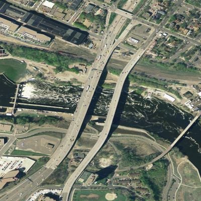
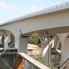
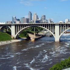
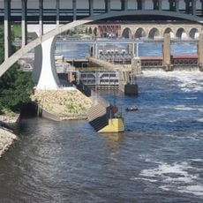
The I-35W Mississippi River bridge was a steel deck arch and truss structure that crossed the Mississippi in Minneapolis, carrying eight lanes of traffic. The structure measured approximately 35 meters high, 34 meters wide, and stretched about 581 meters in length.

The structure opened in 1967 and served as a major traffic link for forty years before collapsing during rush hour in August 2007. Engineers found that undersized steel connecting plates could no longer support the weight of traffic and construction equipment.

The collapse had a profound impact on national infrastructure discussions.

The site of the former crossing is accessible from the riverbank, where visitors can view a memorial garden with 13 steel columns. A new bridge opened in 2008 and now carries the main traffic flow in this location.

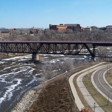
Divers discovered vehicles and debris buried in the riverbed after the collapse, with some wreckage recovered weeks later. Rescue crews worked continuously to locate the missing and assess the safety of nearby buildings.

The community of curious travelers

AroundUs brings together thousands of curated places, local tips, and hidden gems, enriched daily by 60,000 contributors worldwide.

Start exploring
Location
Location
Inception
November 1967
Official opening
November 1967
Height
35.1 m
Length
581 m
Width
34.5 m
Made from material
steel
GPS coordinates
44.97889,-93.24500
Latest update
December 8, 2025 08:20
Vanished architectural structures of the world

This collection documents major buildings that have disappeared throughout history. It includes religious structures such as the 15th-century Porcelain Tower of Nanjing, whose glazed bricks gleamed in sunlight, as well as destroyed palaces, theaters, and public buildings from various periods and...

Around this place
Guthrie Theater
United States of America

Guthrie Theater

816 m
Stone Arch Bridge
United States of America

Stone Arch Bridge

710 m
Weisman Art Museum
United States of America

Weisman Art Museum

873 m
I-35W Saint Anthony Falls Bridge
United States of America

I-35W Saint Anthony Falls Bridge

0 m
Mill City Museum
United States of America

Mill City Museum

954 m
Washington Avenue Bridge
United States of America

Washington Avenue Bridge

785 m
Northrop Auditorium
United States of America

Northrop Auditorium

805 m
Bell Museum of Natural History
United States of America

Bell Museum of Natural History

929 m
University of Minnesota Old Campus Historic District
United States of America

University of Minnesota Old Campus Historic District

657 m
Bohemian Flats
United States of America

Bohemian Flats

490 m
Pillsbury A Mill
United States of America

Pillsbury A Mill

825 m
Rarig Center
United States of America

Rarig Center

967 m
10th Avenue Bridge
United States of America

10th Avenue Bridge

87 m
Mixed Blood Theatre Company
United States of America

Mixed Blood Theatre Company

956 m
Northern Pacific Bridge Number 9
United States of America

Northern Pacific Bridge Number 9

344 m
Walter Library
United States of America

Walter Library

807 m
Jean-Nickolaus Tretter Collection in Gay, Lesbian, Bisexual and Transgender Studies
United States of America

Jean-Nickolaus Tretter Collection in Gay, Lesbian, Bisexual and Transgender Studies

657 m
Gold Medal Park
United States of America

Gold Medal Park

656 m
Southern Theater
United States of America

Southern Theater

658 m
Hennepin Island Hydroelectric Plant
United States of America

Hennepin Island Hydroelectric Plant

823 m
Arvonne Fraser Library
United States of America

Arvonne Fraser Library

608 m
Phi Gamma Delta Fraternity House
United States of America

Phi Gamma Delta Fraternity House

522 m
Horatio P. Van Cleve House
United States of America

Horatio P. Van Cleve House

805 m
Woodbury Fisk House
United States of America

Woodbury Fisk House

860 m
B. O. Cutter House
United States of America

B. O. Cutter House

557 m
Varsity Theater
United States of America

Varsity Theater

668 m
Hennepin Island Park
United States of America

Hennepin Island Park

644 m
Saint Anthony Falls Lower Lock and Dam
United States of America

Saint Anthony Falls Lower Lock and Dam

165 m
Show the full map
« I-35W Mississippi River bridge - Bridge in Minneapolis, Minnesota » is provided by Around Us (aroundus.com). Images and texts are derived from Wikimedia project under a Creative Commons license. You are allowed to copy, distribute, and modify copies of this page, under the conditions set by the license, as long as this note is clearly visible.

Discover hidden gems everywhere you go!

From secret cafés to breathtaking viewpoints, skip the crowded tourist spots and find places that match your style. Our app makes it easy with voice search, smart filtering, route optimization, and insider tips from travelers worldwide. Download now for the complete mobile experience.

Around Us App Screenshot

A unique approach to discovering new places

Le Figaro

All the places worth exploring

France Info

A tailor-made excursion in just a few clicks

20 Minutes

Around Us
Travel Guide & Maps
Download

Send to your phone

QR Code
1

Open the camera app on your mobile.

2

Point at the QR code with your camera. A notification will appear.

3

Tap the notification to open the link.