Enable Location

We need your location to show you interesting places around you

Discover nearby places

Find interesting locations and hidden gems around you

Precise directions

Get accurate directions and distances to places

Your location is never shared with other users. It's only used when you tap the location button.

Natural Bridge State Park

Log in to your account

Start exploring — it's free

Trusted by 62,466 travelers worldwide

Continue with Google
Continue with Apple
or

We will send you a code to connect

By continuing, you accept our Terms and Conditions and our Privacy Policy

Check your inbox

We've sent a pincode in your inbox. Please enter the code below.

Natural Bridge State Park

Natural Bridge State Park, State park in Honey Creek, Wisconsin

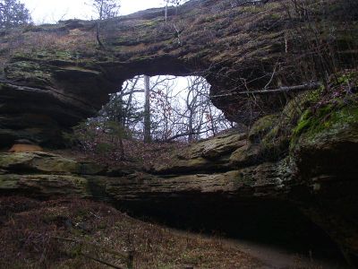
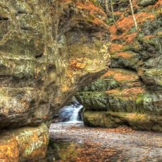
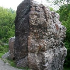
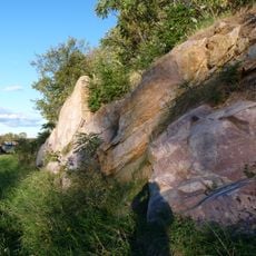
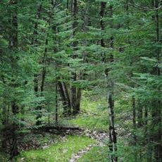
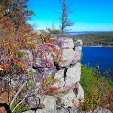
Natural Bridge State Park is a protected area in Honey Creek featuring a dramatic natural sandstone arch formation spanning over a deep canyon. The site includes forested sections, prairie restoration areas, and multiple interconnected hiking paths throughout the landscape.

Indigenous peoples including the Ojibwa and Ho-Chunk nations inhabited the region for centuries and left traces throughout the landscape. The state officially protected this geological formation as a park in 1972 to preserve its natural and archaeological significance.

The park draws visitors who come to walk through the landscape and experience the natural formations firsthand. People spend time here to observe the rock shapes and the way water has shaped the terrain over time.

The trails are open year-round, but conditions vary seasonally with winter making some paths slippery and muddy sections appearing after rain. Sturdy footwear is essential, and visitors should plan extra time to explore the terrain safely.

The sandstone arch was carved by water over millions of years, gradually dissolving softer layers within the dolomite rock formation. This slow geological process created one of the state's most striking natural bridges.

The community of curious travelers

AroundUs brings together thousands of curated places, local tips, and hidden gems, enriched daily by 60,000 contributors worldwide.

Start exploring
Location
Inception
1972
GPS coordinates
43.34420,-89.92970
Latest update
December 11, 2025 11:03
Around this place
Devil's Lake State Park
United States of America

Devil's Lake State Park

19.2 km
Badger Army Ammunition Plant
United States of America

Badger Army Ammunition Plant

14.5 km
Forevertron
United States of America

Forevertron

13 km
Lake Wisconsin
United States of America

Lake Wisconsin

17 km
United States of America

Mid-Continent Railway Museum

13.7 km
International Clown Hall of Fame
United States of America

International Clown Hall of Fame

20.7 km
Pewits Nest State Natural Area
United States of America

Pewits Nest State Natural Area

16.4 km
Van Hise Rock
United States of America

Van Hise Rock

16.2 km
Chicago and North Western Railway 1385
United States of America

Chicago and North Western Railway 1385

13.5 km
Al. Ringling Theatre
United States of America

Al. Ringling Theatre

20.6 km
Our Lady of Loretto Roman Catholic Church and Cemetery
United States of America

Our Lady of Loretto Roman Catholic Church and Cemetery

2.2 km
Freethinkers' Hall
United States of America

Freethinkers' Hall

18.3 km
Point of Rocks
United States of America

Point of Rocks

16.3 km
Sauk County Courthouse
United States of America

Sauk County Courthouse

20.6 km
August W. Derleth House
United States of America

August W. Derleth House

17.6 km
Lachmund Family House
United States of America

Lachmund Family House

18.7 km
Salem Evangelical Church
United States of America

Salem Evangelical Church

8.7 km
Manchester Street Bridge
United States of America

Manchester Street Bridge

19.9 km
Baraboo Public Library
United States of America

Baraboo Public Library

20.5 km
Sauk City Fire Station
United States of America

Sauk City Fire Station

18.7 km
Tim Thering Octagon Barn
United States of America

Tim Thering Octagon Barn

11.3 km
John and Margarethe Kemp Cabin
United States of America

John and Margarethe Kemp Cabin

20.8 km
William Clark House
United States of America

William Clark House

20.2 km
Island Woolen Company Office Building
United States of America

Island Woolen Company Office Building

19.8 km
Ice Age Trail
United States of America

Ice Age Trail

19.5 km
Bonham Theatre & Video
United States of America

Bonham Theatre & Video

17.9 km
West Bluff
United States of America

West Bluff

17.9 km
Sauk City Public Library
United States of America

Sauk City Public Library

18.6 km
Show the full map
« Natural Bridge State Park - State park in Honey Creek, Wisconsin » is provided by Around Us (aroundus.com). Images and texts are derived from Wikimedia project under a Creative Commons license. You are allowed to copy, distribute, and modify copies of this page, under the conditions set by the license, as long as this note is clearly visible.

Discover hidden gems everywhere you go!

From secret cafés to breathtaking viewpoints, skip the crowded tourist spots and find places that match your style. Our app makes it easy with voice search, smart filtering, route optimization, and insider tips from travelers worldwide. Download now for the complete mobile experience.

Around Us App Screenshot

A unique approach to discovering new places

Le Figaro

All the places worth exploring

France Info

A tailor-made excursion in just a few clicks

20 Minutes

Around Us
Travel Guide & Maps
Download

Send to your phone

QR Code
1

Open the camera app on your mobile.

2

Point at the QR code with your camera. A notification will appear.

3

Tap the notification to open the link.