Chest opened
+${chestReward.xp} XP
Explorer
NOUVEAU ×${chestReward.collectible.quantity}
tapez pour fermer
Chest locked

Open chests in the app

Around Us is built for your phone — chests unlock when you walk, explore and capture nearby places.

Enable Location

We need your location to show you interesting places around you

Discover nearby places

Find interesting locations and hidden gems around you

Precise directions

Get accurate directions and distances to places

Your location is never shared with other users. It's only used when you tap the location button.

Gauley River

Log in to your account

Start exploring — it's free

Trusted by 72,887 travelers worldwide

Continue with Google
Continue with Apple
or

We will send you a code to connect

By continuing, you accept our Terms and Conditions and our Privacy Policy

Check your inbox

We've sent a pincode in your inbox. Please enter the code below.

Gauley River
Discussion Reviews 1 Photos
17.6k Popularity

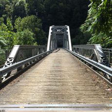
Gauley River, Whitewater rafting river in Appalachian Mountains, United States

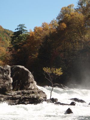
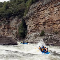
Gauley River flows through the Appalachian Mountains with multiple sections of powerful white water that require skill and experience to navigate. The river offers varied terrain over its length, with some stretches more intense than others.

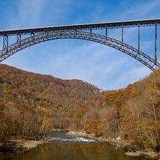
The construction of Summersville Dam in 1966 changed how water flows through the Gauley River, allowing for controlled releases that could be planned in advance. This transformation eventually made the fall rafting season possible.

Whitewater guides in the region have built a deep knowledge of how to read the river's moods and currents, sharing this expertise with visitors who come to experience the water.

Visitors should come prepared for demanding conditions and be ready for physical exertion throughout the trip. Swimming ability and familiarity with whitewater paddling make the experience more enjoyable and manageable.

The fall water releases from Summersville Lake are timed to create consistent whitewater conditions that last for weeks rather than varying with rainfall. This predictable schedule allows visitors to plan trips knowing what the water will be like.

The community of curious travelers

AroundUs brings together thousands of curated places, local tips, and hidden gems, enriched daily by 60,000 contributors worldwide.

Start exploring
Location
GPS coordinates
38.16170,-81.19640
Latest update
December 7, 2025 19:24
Around this place
New River Gorge Bridge
United States of America

New River Gorge Bridge

14.4 km
Summersville Lake
United States of America

Summersville Lake

27.6 km
Hawks Nest State Park
United States of America

Hawks Nest State Park

7.4 km
Babcock State Park
United States of America

Babcock State Park

27.2 km
Carnifex Ferry Battlefield State Park
United States of America

Carnifex Ferry Battlefield State Park

23.2 km
Ace Adventure Resort
United States of America

Ace Adventure Resort

22.7 km
Oak Hill High School
United States of America

Oak Hill High School

19.4 km
Tunney Hunsaker Bridge
United States of America

Tunney Hunsaker Bridge

15 km
Glen Ferris Inn
United States of America

Glen Ferris Inn

2 km
Bank of Glen Jean
United States of America

Bank of Glen Jean

26.2 km
Page-Vawter House
United States of America

Page-Vawter House

8.7 km
Camp Washington-Carver Complex
United States of America

Camp Washington-Carver Complex

26 km
Altamont Hotel
United States of America

Altamont Hotel

14.7 km
Cedar Grove
United States of America

Cedar Grove

21.3 km
Contentment
United States of America

Contentment

8.7 km
Booker T. Washington High School
United States of America

Booker T. Washington High School

15.9 km
E. B. Hawkins House
United States of America

E. B. Hawkins House

14.9 km
Fayetteville Historic District
United States of America

Fayetteville Historic District

14.6 km
Mount Hope Historic District
United States of America

Mount Hope Historic District

30.1 km
Fayette County Courthouse
United States of America

Fayette County Courthouse

14.5 km
New River Company General Office Building
United States of America

New River Company General Office Building

29.7 km
Pratt Historic District
United States of America

Pratt Historic District

17.3 km
Earl M. Vickers Bridge
United States of America

Earl M. Vickers Bridge

10.8 km
Glade Creek Grist Mill
United States of America

Glade Creek Grist Mill

29.8 km
Fayette Station Road
United States of America

Fayette Station Road

14.7 km
Kay Moor
United States of America

Kay Moor

17.1 km
Main Building
United States of America

Main Building

11.4 km
Nuttall Coal Mine Conveyor
United States of America

Nuttall Coal Mine Conveyor

18.2 km
Show the full map
Reviews
Share your experience

No review yet

Discussions
Start a discussion...

No discussion yet

« Gauley River - Whitewater rafting river in Appalachian Mountains, United States » is provided by Around Us (aroundus.com). Images and texts are derived from Wikimedia project under a Creative Commons license. You are allowed to copy, distribute, and modify copies of this page, under the conditions set by the license, as long as this note is clearly visible.

Discover hidden gems everywhere you go!

From secret cafés to breathtaking viewpoints, skip the crowded tourist spots and find places that match your style. Our app makes it easy with voice search, smart filtering, route optimization, and insider tips from travelers worldwide. Download now for the complete mobile experience.

Around Us App Screenshot

A unique approach to discovering new places

Le Figaro

All the places worth exploring

France Info

A tailor-made excursion in just a few clicks

20 Minutes

Around Us
Travel Guide & Maps
Download

Send to your phone

QR Code
1

Open the camera app on your mobile.

2

Point at the QR code with your camera. A notification will appear.

3

Tap the notification to open the link.