Enable Location

We need your location to show you interesting places around you

Discover nearby places

Find interesting locations and hidden gems around you

Precise directions

Get accurate directions and distances to places

Your location is never shared with other users. It's only used when you tap the location button.

Mio

Log in to your account

Start exploring — it's free

Trusted by 64,066 travelers worldwide

Continue with Google
Continue with Apple
or

We will send you a code to connect

By continuing, you accept our Terms and Conditions and our Privacy Policy

Check your inbox

We've sent a pincode in your inbox. Please enter the code below.

Discussion Reviews 1 Photos
17.2k Popularity

Mio, census-designated place in Michigan, United States

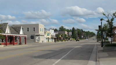
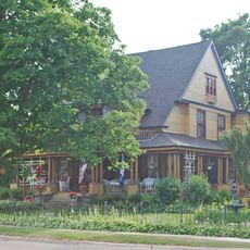
Mio is an unincorporated census-designated place and county seat in Oscoda County, Michigan. The town consists of simple streets with older but well-maintained houses and buildings that reflect the slow pace of small-town life.

Oscoda County was established in 1881, and Mio was chosen as the county seat because of its central location. The first courthouse was built in 1888 and remained the oldest wooden courthouse in Michigan for many years before being destroyed by fire in 2016 and later replaced.

Mio takes its name from a local woman named Marla Deyarmond, whom people called Aunt Mioe because visitors regularly came to her house. The name reflects the personal story of the community and shows how small places often develop their identity from the people who live there.

Visitors should know that Mio is a quiet and simple place, ideal for those who want to explore small-town history. The best time to visit is outside extreme seasons, when outdoor activities like fishing and hiking are easier to access.

Mio owes its name to a local woman named Marla Deyarmond, who was known as Aunt Mioe and regularly attracted visitors who valued her wisdom and hospitality. This unusual naming choice shows how closely small communities are tied to individual people in their history.

The community of curious travelers

AroundUs brings together thousands of curated places, local tips, and hidden gems, enriched daily by 60,000 contributors worldwide.

Start exploring
Location
Elevation above the sea
311 m
GPS coordinates
44.65222,-84.12972
Latest update
February 17, 2026 01:00
Around this place
Hartwick Pines State Park
United States of America

Hartwick Pines State Park

43.9 km
Lumberman's Monument
United States of America

Lumberman's Monument

46.8 km
South Higgins Lake State Park
United States of America

South Higgins Lake State Park

49.7 km
Au Sable State Forest
United States of America

Au Sable State Forest

61.6 km
North Higgins Lake State Park
United States of America

North Higgins Lake State Park

52.1 km
St. Mary, Our Lady of Mount Carmel Cathedral
United States of America

St. Mary, Our Lady of Mount Carmel Cathedral

60.9 km
Dead Stream Flooding State Wildlife Management Area
United States of America

Dead Stream Flooding State Wildlife Management Area

64.4 km
Five Channels Dam
United States of America

Five Channels Dam

42.1 km
Cooke Dam
United States of America

Cooke Dam

48.5 km
Roscommon Zoo
United States of America

Roscommon Zoo

32.2 km
United States of America

Houghton Lake Flats Flooding State Wildlife Management Area

62.2 km
Eggleston School
United States of America

Eggleston School

57.8 km
Edward E. Hartwick Memorial Building
United States of America

Edward E. Hartwick Memorial Building

42.6 km
Douglas House
United States of America

Douglas House

32.5 km
Oscoda County Courthouse
United States of America

Oscoda County Courthouse

328 m
Frank A. and Rae E. Harris Kramer House
United States of America

Frank A. and Rae E. Harris Kramer House

60.1 km
Call of the Wild Museum
United States of America

Call of the Wild Museum

59.8 km
Ogemaw Hills Pathway
United States of America

Ogemaw Hills Pathway

34.5 km
M-72–Au Sable River Bridge
United States of America

M-72–Au Sable River Bridge

46.1 km
Main Beach
United States of America

Main Beach

54.2 km
James A. and Lottie J.
United States of America

James A. and Lottie J.

59.9 km
Dinosaur Gardens
United States of America

Dinosaur Gardens

61.7 km
White Pine National
United States of America

White Pine National

50 km
Wurtsmith Air Museum
United States of America

Wurtsmith Air Museum

65 km
Wild Frontier Fun Park
United States of America

Wild Frontier Fun Park

17.5 km
CoopersVille USA
United States of America

CoopersVille USA

20.1 km
The Beach at Canada Creek Ranch
United States of America

The Beach at Canada Creek Ranch

59.3 km
Au Sable National Scenic River
United States of America

Au Sable National Scenic River

12.8 km
Show the full map
Reviews
Share your experience

No review yet

Discussions
Start a discussion...

No discussion yet

« Mio - census-designated place in Michigan, United States » is provided by Around Us (aroundus.com). Images and texts are derived from Wikimedia project under a Creative Commons license. You are allowed to copy, distribute, and modify copies of this page, under the conditions set by the license, as long as this note is clearly visible.

Discover hidden gems everywhere you go!

From secret cafés to breathtaking viewpoints, skip the crowded tourist spots and find places that match your style. Our app makes it easy with voice search, smart filtering, route optimization, and insider tips from travelers worldwide. Download now for the complete mobile experience.

Around Us App Screenshot

A unique approach to discovering new places

Le Figaro

All the places worth exploring

France Info

A tailor-made excursion in just a few clicks

20 Minutes

Around Us
Travel Guide & Maps
Download

Send to your phone

QR Code
1

Open the camera app on your mobile.

2

Point at the QR code with your camera. A notification will appear.

3

Tap the notification to open the link.