Chest opened
+${chestReward.xp} XP
Explorer
NOUVEAU ×${chestReward.collectible.quantity}
tapez pour fermer
Chest locked

Open chests in the app

Around Us is built for your phone — chests unlock when you walk, explore and capture nearby places.

Enable Location

We need your location to show you interesting places around you

Discover nearby places

Find interesting locations and hidden gems around you

Precise directions

Get accurate directions and distances to places

Your location is never shared with other users. It's only used when you tap the location button.

Au Sable River

Log in to your account

Start exploring — it's free

Trusted by 72,885 travelers worldwide

Continue with Google
Continue with Apple
or

We will send you a code to connect

By continuing, you accept our Terms and Conditions and our Privacy Policy

Check your inbox

We've sent a pincode in your inbox. Please enter the code below.

Au Sable River
Discussion Reviews 1 Photos
24.9k Popularity

Au Sable River, River system in Northern Michigan, United States.

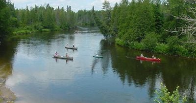
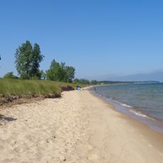
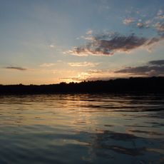
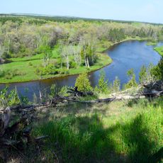
The Au Sable River is a river system in northern Michigan's Lower Peninsula that winds through forested landscapes before flowing into Lake Huron. The waterway offers multiple entry points along its course and features calm stretches suitable for paddling and fishing.

The name comes from French colonial traders who called it Sand River, referring to its sandy banks along the course. This waterway played a role in the fur trade era and has been significant to the region for centuries.

The river shapes how people in the region spend their time, serving as a gathering place for fishing trips and paddling adventures. Communities along its course rely on it for recreation and maintain a strong connection to this waterway.

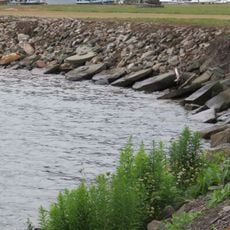
Several access points dot the riverbanks where visitors can launch boats or begin fishing trips at their own pace. The best time to paddle or fish is in spring and fall when water levels are moderate and crowds are lighter.

The river is known for its cold, clear water that draws trout and attracts anglers from across the region. This natural quality has made it one of the best fishing destinations in the eastern part of the country.

The community of curious travelers

AroundUs brings together thousands of curated places, local tips, and hidden gems, enriched daily by 60,000 contributors worldwide.

Start exploring
Location
Elevation above the sea
174 m
GPS coordinates
44.40696,-83.32108
Latest update
December 20, 2025 11:58
Around this place
Turnip Rock
United States of America

Turnip Rock

47.5 km
Lumberman's Monument
United States of America

Lumberman's Monument

24.3 km
Port Crescent State Park
United States of America

Port Crescent State Park

49.6 km
Sturgeon Point Light
United States of America

Sturgeon Point Light

34 km
Tawas Point State Park
United States of America

Tawas Point State Park

19.6 km
Harrisville State Park
United States of America

Harrisville State Park

26.9 km
Tawas Point Light
United States of America

Tawas Point Light

19.9 km
Negwegon State Park
United States of America

Negwegon State Park

50 km
Charity Island Light
United States of America

Charity Island Light

42.2 km
Grindstone City Historic District
United States of America

Grindstone City Historic District

51.8 km
Port Austin Light
United States of America

Port Austin Light

45 km
Gravelly Shoal Light
United States of America

Gravelly Shoal Light

46.6 km
Tawas Point Camper's Beach
United States of America

Tawas Point Camper's Beach

19.4 km
Alabaster Historic District
United States of America

Alabaster Historic District

31.4 km
Five Channels Dam
United States of America

Five Channels Dam

28.8 km
Cooke Dam
United States of America

Cooke Dam

21.2 km
St. Peter's Lutheran Church Kinde, Michigan
United States of America

St. Peter's Lutheran Church Kinde, Michigan

57.9 km
Harrisville State Park Beach
United States of America

Harrisville State Park Beach

26.9 km
Huron City Historic District
United States of America

Huron City Historic District

57.2 km
Charles G. Learned House
United States of America

Charles G. Learned House

48.3 km
Second Arenac County Courthouse
United States of America

Second Arenac County Courthouse

58.4 km
Dinosaur Gardens
United States of America

Dinosaur Gardens

57.4 km
Smith-Culhane House
United States of America

Smith-Culhane House

48.2 km
Winsor and Snover Bank Building
United States of America

Winsor and Snover Bank Building

48.1 km
Caseville Harbor Light
United States of America

Caseville Harbor Light

51.4 km
White Pine National
United States of America

White Pine National

41.4 km
Wurtsmith Air Museum
United States of America

Wurtsmith Air Museum

6.4 km
Au Sable National Scenic River
United States of America

Au Sable National Scenic River

57.9 km
Show the full map
Reviews
Share your experience

No review yet

Discussions
Start a discussion...

No discussion yet

« Au Sable River - River system in Northern Michigan, United States » is provided by Around Us (aroundus.com). Images and texts are derived from Wikimedia project under a Creative Commons license. You are allowed to copy, distribute, and modify copies of this page, under the conditions set by the license, as long as this note is clearly visible.

Discover hidden gems everywhere you go!

From secret cafés to breathtaking viewpoints, skip the crowded tourist spots and find places that match your style. Our app makes it easy with voice search, smart filtering, route optimization, and insider tips from travelers worldwide. Download now for the complete mobile experience.

Around Us App Screenshot

A unique approach to discovering new places

Le Figaro

All the places worth exploring

France Info

A tailor-made excursion in just a few clicks

20 Minutes

Around Us
Travel Guide & Maps
Download

Send to your phone

QR Code
1

Open the camera app on your mobile.

2

Point at the QR code with your camera. A notification will appear.

3

Tap the notification to open the link.