Enable Location

We need your location to show you interesting places around you

Discover nearby places

Find interesting locations and hidden gems around you

Precise directions

Get accurate directions and distances to places

Your location is never shared with other users. It's only used when you tap the location button.

Calle 25 de Enero

Log in to your account

Start exploring — it's free

Trusted by 63,224 travelers worldwide

Continue with Google
Continue with Apple
or

We will send you a code to connect

By continuing, you accept our Terms and Conditions and our Privacy Policy

Check your inbox

We've sent a pincode in your inbox. Please enter the code below.

Calle 25 de Enero
Discussion Reviews 1 Photos
3k Popularity

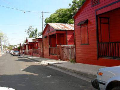
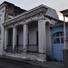
Calle 25 de Enero, Historic Victorian street in Ponce, Puerto Rico.

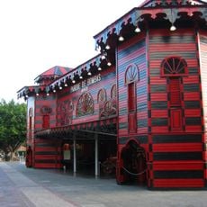
Calle 25 de Enero is a residential street in Ponce lined with Victorian-style houses painted in a distinctive red and black striped pattern. The uniform coloring of the homes creates a cohesive visual block that stands out in the neighborhood's architecture.

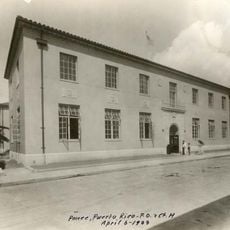
The street was created following the El Polvorin fire of 1899, a major disaster that prompted the construction of dedicated homes for volunteer firefighters and their families. The founding of this residential area was a direct response to the city's need for organized firefighting services.

The red and black painted homes reflect how the community honors its firefighting heroes through visual symbols on the streetscape. Residents maintain these colors as a way to keep the memory of those who served alive in their daily surroundings.

The street is best explored on foot to appreciate the architectural details and informational plaques along the way at your own pace. Visiting during early morning or late afternoon hours offers better lighting for photography and a more relaxed experience.

The red and black color scheme was intentionally chosen to honor firefighters, as these were the colors of their uniforms during that era. The street represents a rare case where an entire residential block was dedicated to commemorating a single profession and its symbols.

The community of curious travelers

AroundUs brings together thousands of curated places, local tips, and hidden gems, enriched daily by 60,000 contributors worldwide.

Start exploring
Location
Location
GPS coordinates
18.01330,-66.62260
Latest update
December 12, 2025 12:03
Around this place
Museo Parque de Bombas
United States of America

Museo Parque de Bombas

951 m
Castillo Serrallés
United States of America

Castillo Serrallés

695 m
Ponce City Hall
United States of America

Ponce City Hall

964 m
Cruceta del Vigía
United States of America

Cruceta del Vigía

683 m
Plaza las Delicias
United States of America

Plaza las Delicias

930 m
Hotel Meliá
United States of America

Hotel Meliá

991 m
Plaza del Mercado de Ponce
United States of America

Plaza del Mercado de Ponce

974 m
Ponce Ramada Hotel
United States of America

Ponce Ramada Hotel

847 m
Román Baldorioty de Castro National Pantheon
United States of America

Román Baldorioty de Castro National Pantheon

583 m
Wiechers–Villaronga House
United States of America

Wiechers–Villaronga House

725 m
Museo Castillo Serrallés
United States of America

Museo Castillo Serrallés

695 m
Teatro Fox Delicias
United States of America

Teatro Fox Delicias

891 m
Casa Vives
United States of America

Casa Vives

957 m
Parque del Retiro
United States of America

Parque del Retiro

541 m
Museo de la Arquitectura Ponceña
United States of America

Museo de la Arquitectura Ponceña

727 m
Plaza Degetau
United States of America

Plaza Degetau

948 m
Antiguo Hospital Tricoche
United States of America

Antiguo Hospital Tricoche

897 m
Bank of Ponce
United States of America

Bank of Ponce

1 km
First United Methodist Church of Ponce
United States of America

First United Methodist Church of Ponce

697 m
Paseo Atocha
United States of America

Paseo Atocha

954 m
Centro Español de Ponce
United States of America

Centro Español de Ponce

786 m
Subirá House
United States of America

Subirá House

700 m
Ponce YMCA Building
United States of America

Ponce YMCA Building

1 km
Monumento a los heroes de El Polvorín
United States of America

Monumento a los heroes de El Polvorín

964 m
Rosaly–Batiz House
United States of America

Rosaly–Batiz House

367 m
Luis A. Ferré United States Courthouse and Post Office Building
United States of America

Luis A. Ferré United States Courthouse and Post Office Building

938 m
Zaldo de Nebot Residence
United States of America

Zaldo de Nebot Residence

1 km
Fuente de los Leones
United States of America

Fuente de los Leones

942 m
Show the full map
Reviews
Share your experience

No review yet

Discussions
Start a discussion...

No discussion yet

« Calle 25 de Enero - Historic Victorian street in Ponce, Puerto Rico » is provided by Around Us (aroundus.com). Images and texts are derived from Wikimedia project under a Creative Commons license. You are allowed to copy, distribute, and modify copies of this page, under the conditions set by the license, as long as this note is clearly visible.

Discover hidden gems everywhere you go!

From secret cafés to breathtaking viewpoints, skip the crowded tourist spots and find places that match your style. Our app makes it easy with voice search, smart filtering, route optimization, and insider tips from travelers worldwide. Download now for the complete mobile experience.

Around Us App Screenshot

A unique approach to discovering new places

Le Figaro

All the places worth exploring

France Info

A tailor-made excursion in just a few clicks

20 Minutes

Around Us
Travel Guide & Maps
Download

Send to your phone

QR Code
1

Open the camera app on your mobile.

2

Point at the QR code with your camera. A notification will appear.

3

Tap the notification to open the link.