Chest opened
+${chestReward.xp} XP
Explorer
NOUVEAU ×${chestReward.collectible.quantity}
tapez pour fermer
Chest locked

Open chests in the app

Around Us is built for your phone — chests unlock when you walk, explore and capture nearby places.

Enable Location

We need your location to show you interesting places around you

Discover nearby places

Find interesting locations and hidden gems around you

Precise directions

Get accurate directions and distances to places

Your location is never shared with other users. It's only used when you tap the location button.

Cerro Las Tetas

Log in to your account

Start exploring — it's free

Trusted by 72,883 travelers worldwide

Continue with Google
Continue with Apple
or

We will send you a code to connect

By continuing, you accept our Terms and Conditions and our Privacy Policy

Check your inbox

We've sent a pincode in your inbox. Please enter the code below.

Cerro Las Tetas
Discussion Reviews 1 Photos
9.2k Popularity

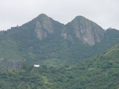
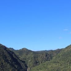
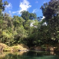
Cerro Las Tetas, Mountain peaks in Salinas, Puerto Rico.

Cerro Las Tetas consists of two mountain peaks that rise from the Sierra de Cayey range in southern Puerto Rico. These summits reach approximately 2,762 feet high and form a distinctive part of the landscape near Salinas.

The mountain area was protected when the Las Piedras del Collado Nature Reserve was created in 2000. This action recognized the ecological importance of the region and its role in preserving the natural environment.

The local Spanish name 'Las Tetas' comes from how the two peaks resemble feminine curves. This name is widely used by residents and visitors when they talk about the place.

The peaks are easily reached from Puerto Rico Highway 52, with a rest area at kilometer 49 nearby. This location offers clear views for photography and observation of both summits.

The mountain area features weathered basalt formations with natural ridges and edges throughout the rock faces. These geological elements create interesting climbing routes for those interested in technical ascents.

The community of curious travelers

AroundUs brings together thousands of curated places, local tips, and hidden gems, enriched daily by 60,000 contributors worldwide.

Start exploring
Location
Location
Elevation above the sea
2,762 ft
GPS coordinates
18.09333,-66.23139
Latest update
December 10, 2025 15:58
Around this place
Monumento al Jíbaro Puertorriqueño
United States of America

Monumento al Jíbaro Puertorriqueño

2.8 km
Central Aguirre Historic District
United States of America

Central Aguirre Historic District

15.4 km
United States of America

Carite State Forest

19.1 km
Casa Cautiño
United States of America

Casa Cautiño

17.3 km
Arenas Bridge
United States of America

Arenas Bridge

10.9 km
San Blas de Illescas Church (Coamo)
United States of America

San Blas de Illescas Church (Coamo)

13.3 km
United States of America

La Robleda Natural Protected Area

8.7 km
Old Plata Bridge
United States of America

Old Plata Bridge

23.7 km
Punta de las Figuras Light
United States of America

Punta de las Figuras Light

24.8 km
William Miranda Marín Botanical and Cultural Garden
United States of America

William Miranda Marín Botanical and Cultural Garden

25.5 km
Cayey Bridge
United States of America

Cayey Bridge

15.9 km
Planadas-Yeyesa Nature Reserve
United States of America

Planadas-Yeyesa Nature Reserve

1.7 km
Punta Petrona
United States of America

Punta Petrona

23.6 km
La Liendre Bridge
United States of America

La Liendre Bridge

11.5 km
Puente de las Calabazas
United States of America

Puente de las Calabazas

8.7 km
Pico Pomar Residence
United States of America

Pico Pomar Residence

13.3 km
Casa Natal de Luis Muñoz Rivera
United States of America

Casa Natal de Luis Muñoz Rivera

13.4 km
Eleuterio Derkes Grammar School
United States of America

Eleuterio Derkes Grammar School

17.7 km
General Méndez Vigo Bridge
United States of America

General Méndez Vigo Bridge

15.5 km
Río Hondo Bridge
United States of America

Río Hondo Bridge

12.9 km
Hacienda Los Maldonado
Puerto Rico

Hacienda Los Maldonado

4.2 km
Cascada Charco Prieto
Puerto Rico

Cascada Charco Prieto

21.7 km
Charco Azul
Puerto Rico

Charco Azul

21.2 km
La Casa del Cuento y de la Historia Cayeyana Ramón "Moncho" Gómez
United States of America

La Casa del Cuento y de la Historia Cayeyana Ramón "Moncho" Gómez

7.4 km
Casa y Museo del Poeta Luis Palés Matos
Puerto Rico

Casa y Museo del Poeta Luis Palés Matos

17.5 km
Carretera Central historic district
United States of America

Carretera Central historic district

7.4 km
Lago Toa Vaca
United States of America

Lago Toa Vaca

25.6 km
Lago Patillas
United States of America

Lago Patillas

23.5 km
Show the full map
Reviews
Share your experience

No review yet

Discussions
Start a discussion...

No discussion yet

« Cerro Las Tetas - Mountain peaks in Salinas, Puerto Rico » is provided by Around Us (aroundus.com). Images and texts are derived from Wikimedia project under a Creative Commons license. You are allowed to copy, distribute, and modify copies of this page, under the conditions set by the license, as long as this note is clearly visible.

Discover hidden gems everywhere you go!

From secret cafés to breathtaking viewpoints, skip the crowded tourist spots and find places that match your style. Our app makes it easy with voice search, smart filtering, route optimization, and insider tips from travelers worldwide. Download now for the complete mobile experience.

Around Us App Screenshot

A unique approach to discovering new places

Le Figaro

All the places worth exploring

France Info

A tailor-made excursion in just a few clicks

20 Minutes

Around Us
Travel Guide & Maps
Download

Send to your phone

QR Code
1

Open the camera app on your mobile.

2

Point at the QR code with your camera. A notification will appear.

3

Tap the notification to open the link.