Chest opened
+${chestReward.xp} XP
Explorer
NOUVEAU ×${chestReward.collectible.quantity}
tapez pour fermer
Chest locked

Open chests in the app

Around Us is built for your phone — chests unlock when you walk, explore and capture nearby places.

Enable Location

We need your location to show you interesting places around you

Discover nearby places

Find interesting locations and hidden gems around you

Precise directions

Get accurate directions and distances to places

Your location is never shared with other users. It's only used when you tap the location button.

Log in to your account

Start exploring — it's free

Trusted by 72,879 travelers worldwide

Continue with Google
Continue with Apple
or

We will send you a code to connect

By continuing, you accept our Terms and Conditions and our Privacy Policy

Check your inbox

We've sent a pincode in your inbox. Please enter the code below.

Christiansbrunn
Discussion Reviews Photo
1.2k Popularity

Christiansbrunn, German settlement community in Nazareth area, Pennsylvania, United States.

Christiansbrunn was a Moravian settlement near Nazareth, Pennsylvania, that relied on water power to operate its mills and support productive industries. The community occupied about 1,500 acres of farmland and combined agricultural work with milling operations and various craft production.

The settlement began in 1749 as a Moravian religious community where unmarried men lived and worked under strict communal organization and spiritual discipline. Church leadership dissolved the settlement in 1796, ending this distinctive experiment in communal living.

The community became known for training young men in various crafts including shoemaking, writing, and silk production that shaped regional economic activity. These practical skills reflected the Moravian belief in meaningful work as a spiritual discipline.

The site can be reached from nearby Nazareth or surrounding communities by local roads leading to remaining structures. To learn more about the settlement, researchers can access historical records and documentation at the Moravian Archives in Bethlehem, Pennsylvania.

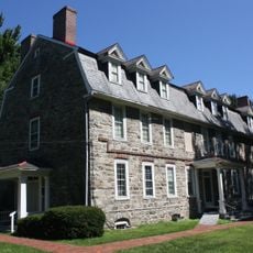
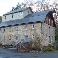
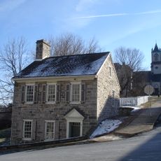
The Familienhaus, a stone structure, remains as the last building from the original settlement and once housed the couples who managed community affairs. This surviving structure offers a tangible connection to how leadership lived and operated the settlement.

The community of curious travelers

AroundUs brings together thousands of curated places, local tips, and hidden gems, enriched daily by 60,000 contributors worldwide.

Start exploring
Location
GPS coordinates
40.74300,-75.35700
Latest update
December 14, 2025 18:03
Around this place
Nazareth Speedway
United States of America

Nazareth Speedway

3.5 km
Martin Tower
United States of America

Martin Tower

12.8 km
Bushkill Park
United States of America

Bushkill Park

10 km
Jacobsburg Environmental Education Center
United States of America

Jacobsburg Environmental Education Center

6.8 km
Fisher Stadium
United States of America

Fisher Stadium

13.2 km
State Theatre
United States of America

State Theatre

13.5 km
United States of America

Indian Tower

2.9 km
Easton Area Public Library
United States of America

Easton Area Public Library

13.4 km
Burnside Plantation
United States of America

Burnside Plantation

12.8 km
Easton Cemetery
United States of America

Easton Cemetery

12.7 km
Pembroke Village
United States of America

Pembroke Village

12.5 km
College Hill Residential Historic District
United States of America

College Hill Residential Historic District

13.5 km
Whitefield House and Gray Cottage
United States of America

Whitefield House and Gray Cottage

4.2 km
Zeta Psi Fraternity House
United States of America

Zeta Psi Fraternity House

13.6 km
United States of America

Nurture Nature Center

13.4 km
Kreidersville Covered Bridge
United States of America

Kreidersville Covered Bridge

11.7 km
Sky Zone Bethlehem
United States of America

Sky Zone Bethlehem

11.9 km
Lee and Virginia Graver Arboretum
United States of America

Lee and Virginia Graver Arboretum

6.4 km
Illick's Mill
United States of America

Illick's Mill

11.5 km
Easton Historic District
United States of America

Easton Historic District

13.6 km
Chain Bridge
United States of America

Chain Bridge

13.5 km
Jacob Nicholas House
United States of America

Jacob Nicholas House

13.5 km
Elmwood Park Historic District
United States of America

Elmwood Park Historic District

13.2 km
Daniel Steckel House
United States of America

Daniel Steckel House

3.6 km
Holy Ghost Ukrainian Catholic Church
United States of America

Holy Ghost Ukrainian Catholic Church

12.5 km
Bar-Don Lanes
United States of America

Bar-Don Lanes

11.2 km
Karl Stirner Arts Trail
United States of America

Karl Stirner Arts Trail

12.7 km
Nazareth Historic District
United States of America

Nazareth Historic District

3.9 km
Show the full map
Reviews
Share your experience

No review yet

Discussions
Start a discussion...

No discussion yet

« Christiansbrunn - German settlement community in Nazareth area, Pennsylvania, United States » is provided by Around Us (aroundus.com). Images and texts are derived from Wikimedia project under a Creative Commons license. You are allowed to copy, distribute, and modify copies of this page, under the conditions set by the license, as long as this note is clearly visible.

Discover hidden gems everywhere you go!

From secret cafés to breathtaking viewpoints, skip the crowded tourist spots and find places that match your style. Our app makes it easy with voice search, smart filtering, route optimization, and insider tips from travelers worldwide. Download now for the complete mobile experience.

Around Us App Screenshot

A unique approach to discovering new places

Le Figaro

All the places worth exploring

France Info

A tailor-made excursion in just a few clicks

20 Minutes

Around Us
Travel Guide & Maps
Download

Send to your phone

QR Code
1

Open the camera app on your mobile.

2

Point at the QR code with your camera. A notification will appear.

3

Tap the notification to open the link.