Chest opened
+${chestReward.xp} XP
Explorer
NOUVEAU ×${chestReward.collectible.quantity}
tapez pour fermer
Chest locked

Open chests in the app

Around Us is built for your phone — chests unlock when you walk, explore and capture nearby places.

Enable Location

We need your location to show you interesting places around you

Discover nearby places

Find interesting locations and hidden gems around you

Precise directions

Get accurate directions and distances to places

Your location is never shared with other users. It's only used when you tap the location button.

Clinch Mountain

Log in to your account

Start exploring — it's free

Trusted by 72,877 travelers worldwide

Continue with Google
Continue with Apple
or

We will send you a code to connect

By continuing, you accept our Terms and Conditions and our Privacy Policy

Check your inbox

We've sent a pincode in your inbox. Please enter the code below.

Clinch Mountain
Discussion Reviews 1 Photos
14k Popularity

Clinch Mountain, Mountain ridge in Tennessee, United States.

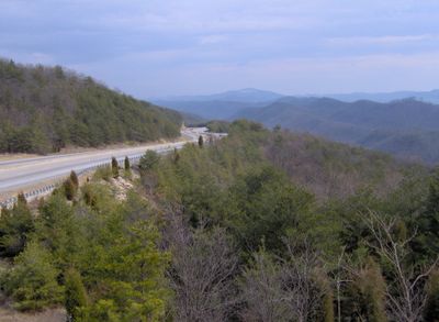
Clinch Mountain is a ridge running through Tennessee with varying elevations along its length and multiple hiking paths. The formation separates two river valleys and creates a clear geographic division in the landscape.

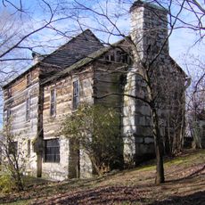
The ridge served military purposes during the Civil War, with Signal Point peak used for sending messages between army units. An important mountain pass also channeled early travelers and traders through the terrain for centuries.

The ridge appears in traditional folk songs tied to the region, reflecting how locals connect this landscape to their own stories and heritage. Music recordings from earlier generations often mention this place, showing its role in shaping the area's identity.

The ridge can be reached from multiple roads and offers several entry points for hiking and exploration. The trails vary in difficulty, so check your fitness level before heading out.

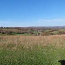
The ridge acts as a natural divide between two river systems, making it a geographic turning point in the area. Visitors can observe this separation while exploring the heights and seeing how different river valleys fall away on each side.

The community of curious travelers

AroundUs brings together thousands of curated places, local tips, and hidden gems, enriched daily by 60,000 contributors worldwide.

Start exploring
Location
GPS coordinates
36.43333,-82.96667
Latest update
December 7, 2025 20:24
Around this place
United States Penitentiary
United States of America

United States Penitentiary

30.2 km
Natural Tunnel State Park
United States of America

Natural Tunnel State Park

36.1 km
Andrew Johnson National Cemetery
United States of America

Andrew Johnson National Cemetery

33 km
Crockett Tavern Museum
United States of America

Crockett Tavern Museum

35.8 km
Vardy Community School
United States of America

Vardy Community School

26 km
Earnest Farms Historic District
United States of America

Earnest Farms Historic District

36.6 km
Tate Springs Springhouse
United States of America

Tate Springs Springhouse

35.6 km
The Cedars Natural Area Preserve
United States of America

The Cedars Natural Area Preserve

31.5 km
Amis House
United States of America

Amis House

1.8 km
Greeneville Historic District
United States of America

Greeneville Historic District

32.7 km
Bethesda Presbyterian Church
United States of America

Bethesda Presbyterian Church

31.2 km
Rogersville Historic District
United States of America

Rogersville Historic District

4.5 km
Hawkins County Courthouse
United States of America

Hawkins County Courthouse

4.6 km
United States of America

Overton Lodge

3.5 km
Bulls Gap Historic District
United States of America

Bulls Gap Historic District

22.8 km
Conway Bridge
United States of America

Conway Bridge

37.3 km
Maden Hall Farm
United States of America

Maden Hall Farm

28.6 km
Price Public Elementary School
United States of America

Price Public Elementary School

4.6 km
St. Marks Presbyterian Church
United States of America

St. Marks Presbyterian Church

4.6 km
New Providence Presbyterian Church, Academy, and Cemetery
United States of America

New Providence Presbyterian Church, Academy, and Cemetery

14.5 km
Stony Point
United States of America

Stony Point

14.4 km
Jonesville Methodist Campground
United States of America

Jonesville Methodist Campground

31.9 km
Long Meadow
United States of America

Long Meadow

12.5 km
Gate City Historic District
United States of America

Gate City Historic District

37.4 km
Boatyard Historic District
United States of America

Boatyard Historic District

34.9 km
Dickinson-Milbourn House
United States of America

Dickinson-Milbourn House

31.5 km
Hale Springs Inn
United States of America

Hale Springs Inn

4.7 km
Olympia Lanes
United States of America

Olympia Lanes

32.6 km
Show the full map
Reviews
Share your experience

No review yet

Discussions
Start a discussion...

No discussion yet

« Clinch Mountain - Mountain ridge in Tennessee, United States » is provided by Around Us (aroundus.com). Images and texts are derived from Wikimedia project under a Creative Commons license. You are allowed to copy, distribute, and modify copies of this page, under the conditions set by the license, as long as this note is clearly visible.

Discover hidden gems everywhere you go!

From secret cafés to breathtaking viewpoints, skip the crowded tourist spots and find places that match your style. Our app makes it easy with voice search, smart filtering, route optimization, and insider tips from travelers worldwide. Download now for the complete mobile experience.

Around Us App Screenshot

A unique approach to discovering new places

Le Figaro

All the places worth exploring

France Info

A tailor-made excursion in just a few clicks

20 Minutes

Around Us
Travel Guide & Maps
Download

Send to your phone

QR Code
1

Open the camera app on your mobile.

2

Point at the QR code with your camera. A notification will appear.

3

Tap the notification to open the link.