Chest opened
+${chestReward.xp} XP
Explorer
NOUVEAU ×${chestReward.collectible.quantity}
tapez pour fermer
Chest locked

Open chests in the app

Around Us is built for your phone — chests unlock when you walk, explore and capture nearby places.

Enable Location

We need your location to show you interesting places around you

Discover nearby places

Find interesting locations and hidden gems around you

Precise directions

Get accurate directions and distances to places

Your location is never shared with other users. It's only used when you tap the location button.

Log in to your account

Start exploring — it's free

Trusted by 72,878 travelers worldwide

Continue with Google
Continue with Apple
or

We will send you a code to connect

By continuing, you accept our Terms and Conditions and our Privacy Policy

Check your inbox

We've sent a pincode in your inbox. Please enter the code below.

Discussion Reviews Photo
1.3k Popularity

Clear Lake Site, Archaeological site in Sand Ridge State Park, Illinois, United States.

Clear Lake Site is an archaeological location in Sand Ridge State Park covering 9.5 acres with remains of a settlement and two burial mounds from prehistoric times. The place holds artifacts and structural evidence from multiple periods of habitation spanning thousands of years.

University researchers began studying this location in 1932 and uncovered thousands of pottery pieces throughout their work. The excavations revealed that people inhabited the area continuously over many centuries.

Multiple communities occupied this location across centuries, leaving behind evidence of how they lived and organized their settlements. The site shows how people from different periods used the same land and adapted to changes over time.

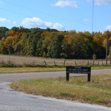
This location is situated within Sand Ridge State Park and can be explored as part of a park visit. The recovered items are displayed at the Illinois State Museum, where visitors can learn more about regional archaeology.

Excavations here uncovered every type of pottery known to the region, making it a key reference point for researchers. This complete collection helped archaeologists understand differences between the various groups that lived here.

The community of curious travelers

AroundUs brings together thousands of curated places, local tips, and hidden gems, enriched daily by 60,000 contributors worldwide.

Start exploring
Location
GPS coordinates
40.42278,-89.78000
Latest update
December 14, 2025 17:42
Around this place
Peoria State Hospital
United States of America

Peoria State Hospital

26 km
Fort Crevecoeur
United States of America

Fort Crevecoeur

29.1 km
Emiquon National Wildlife Refuge
United States of America

Emiquon National Wildlife Refuge

28.6 km
Sand Ridge State Forest
United States of America

Sand Ridge State Forest

7.4 km
Glasford crater
United States of America

Glasford crater

19.7 km
Chautauqua National Wildlife Refuge
United States of America

Chautauqua National Wildlife Refuge

19.4 km
Spring Lake State Fish and Wildlife Area
United States of America

Spring Lake State Fish and Wildlife Area

8 km
Powerton Lake State Fish and Wildlife Area
United States of America

Powerton Lake State Fish and Wildlife Area

15.5 km
Banner Marsh State Fish and Wildlife Area
United States of America

Banner Marsh State Fish and Wildlife Area

13.9 km
Rice Lake State Fish and Wildlife Area
United States of America

Rice Lake State Fish and Wildlife Area

12.9 km
Rockwell Mound
United States of America

Rockwell Mound

27.6 km
John T. McNaughton Bridge
United States of America

John T. McNaughton Bridge

19.9 km
Ulysses G. Orendorff House
United States of America

Ulysses G. Orendorff House

26.3 km
Peoria Lock and Dam
United States of America

Peoria Lock and Dam

26.7 km
Tazewell County Courthouse
United States of America

Tazewell County Courthouse

19.8 km
Shade-Lohmann Bridge
United States of America

Shade-Lohmann Bridge

27.1 km
Havana Water Tower
United States of America

Havana Water Tower

27.3 km
Pleasant Grove School
United States of America

Pleasant Grove School

28.9 km
Canton Lake
United States of America

Canton Lake

22.6 km
Carl Herget Mansion
United States of America

Carl Herget Mansion

19.4 km
Havana Public Library
United States of America

Havana Public Library

27.6 km
Parlin Library
United States of America

Parlin Library

26.3 km
Waltmire Bridge
United States of America

Waltmire Bridge

24.6 km
Ayer Public Library
United States of America

Ayer Public Library

20.5 km
Scott Wike Lucas Bridge
United States of America

Scott Wike Lucas Bridge

28.4 km
Pekin Federal Building
United States of America

Pekin Federal Building

19.7 km
Third Street Bridge
United States of America

Third Street Bridge

20.7 km
East Waterford School
United States of America

East Waterford School

29.6 km
Show the full map
Reviews
Share your experience

No review yet

Discussions
Start a discussion...

No discussion yet

« Clear Lake Site - Archaeological site in Sand Ridge State Park, Illinois, United States » is provided by Around Us (aroundus.com). Images and texts are derived from Wikimedia project under a Creative Commons license. You are allowed to copy, distribute, and modify copies of this page, under the conditions set by the license, as long as this note is clearly visible.

Discover hidden gems everywhere you go!

From secret cafés to breathtaking viewpoints, skip the crowded tourist spots and find places that match your style. Our app makes it easy with voice search, smart filtering, route optimization, and insider tips from travelers worldwide. Download now for the complete mobile experience.

Around Us App Screenshot

A unique approach to discovering new places

Le Figaro

All the places worth exploring

France Info

A tailor-made excursion in just a few clicks

20 Minutes

Around Us
Travel Guide & Maps
Download

Send to your phone

QR Code
1

Open the camera app on your mobile.

2

Point at the QR code with your camera. A notification will appear.

3

Tap the notification to open the link.