Chest opened
+${chestReward.xp} XP
Explorer
NOUVEAU ×${chestReward.collectible.quantity}
tapez pour fermer
Chest locked

Open chests in the app

Around Us is built for your phone — chests unlock when you walk, explore and capture nearby places.

Enable Location

We need your location to show you interesting places around you

Discover nearby places

Find interesting locations and hidden gems around you

Precise directions

Get accurate directions and distances to places

Your location is never shared with other users. It's only used when you tap the location button.

Log in to your account

Start exploring — it's free

Trusted by 72,880 travelers worldwide

Continue with Google
Continue with Apple
or

We will send you a code to connect

By continuing, you accept our Terms and Conditions and our Privacy Policy

Check your inbox

We've sent a pincode in your inbox. Please enter the code below.

Custis Trail
Discussion Reviews Photo
4.1k Popularity

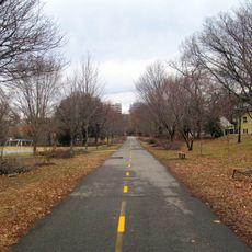
Custis Trail, Paved trail in Arlington County, Virginia, US.

Custis Trail is a paved path in Arlington County, Virginia, connecting two major cycling routes in the region. It runs mostly beneath Interstate 66, forming a sheltered corridor for people on foot or on a bike.

The path was built in the late 1970s alongside the construction of Interstate 66 in the area. It was part of a broader effort to reduce car traffic and offer people an alternative way to move through the region.

The trail functions as a connector linking residential neighborhoods and allowing residents to move through the area without using roads. This role shapes how locals view and use the path as part of their daily routines.

The surface is smooth and paved the whole way, which makes it easy to use on foot or by bike. The path rises gradually from east to west, so going in that direction means a steady uphill effort.

At its eastern end, the trail crosses several streets before opening into a long section running under the highway with no interruptions. This shift from exposed crossings to a sheltered stretch gives the route a noticeably different feel depending on where you are.

The community of curious travelers

AroundUs brings together thousands of curated places, local tips, and hidden gems, enriched daily by 60,000 contributors worldwide.

Start exploring
Location
GPS coordinates
38.88720,-77.11740
Latest update
March 3, 2026 10:04
Around this place
Arlington Hall
United States of America

Arlington Hall

2.5 km
Columbia Gardens Cemetery
United States of America

Columbia Gardens Cemetery

2.8 km
Westover
United States of America

Westover

1.9 km
Dominion Hills Historic District
United States of America

Dominion Hills Historic District

2.4 km
Unitarian Universalist Church of Arlington
United States of America

Unitarian Universalist Church of Arlington

2.3 km
Fort C. F. Smith
United States of America

Fort C. F. Smith

2.8 km
Glebe House
United States of America

Glebe House

502 m
Lyon Park Historic District
United States of America

Lyon Park Historic District

2.5 km
Bluemont Junction Trail
United States of America

Bluemont Junction Trail

1.4 km
Arlington Forest Historic District
United States of America

Arlington Forest Historic District

1.9 km
Glebewood Village Historic District
United States of America

Glebewood Village Historic District

1.7 km
Maywood Historic District
United States of America

Maywood Historic District

1.8 km
Clarendon School
United States of America

Clarendon School

1.5 km
Lee Gardens North Historic District
United States of America

Lee Gardens North Historic District

2.7 km
Windy Run
United States of America

Windy Run

2.9 km
Ball-Sellers House
United States of America

Ball-Sellers House

2.7 km
Cherrydale Historic District
United States of America

Cherrydale Historic District

1.1 km
Calvert Manor
United States of America

Calvert Manor

2.4 km
Monroe Courts Historic District
United States of America

Monroe Courts Historic District

1.1 km
Mount Olivet United Methodist Church
United States of America

Mount Olivet United Methodist Church

2.2 km
Buckingham Historic District
United States of America

Buckingham Historic District

1.7 km
United States Post Office (Arlington, Virginia)
United States of America

United States Post Office (Arlington, Virginia)

1.9 km
Westover Historic District
United States of America

Westover Historic District

1.7 km
Saegmuller House
United States of America

Saegmuller House

2.9 km
Highland Park-Overlee Knolls
United States of America

Highland Park-Overlee Knolls

2.6 km
Waverly Hills Historic District
United States of America

Waverly Hills Historic District

523 m
Birchwood
United States of America

Birchwood

2.2 km
First Presbyterian Church
United States of America

First Presbyterian Church

1.2 km
Show the full map
Reviews
Share your experience

No review yet

Discussions
Start a discussion...

No discussion yet

« Custis Trail - Paved trail in Arlington County, Virginia, US » is provided by Around Us (aroundus.com). Images and texts are derived from Wikimedia project under a Creative Commons license. You are allowed to copy, distribute, and modify copies of this page, under the conditions set by the license, as long as this note is clearly visible.

Discover hidden gems everywhere you go!

From secret cafés to breathtaking viewpoints, skip the crowded tourist spots and find places that match your style. Our app makes it easy with voice search, smart filtering, route optimization, and insider tips from travelers worldwide. Download now for the complete mobile experience.

Around Us App Screenshot

A unique approach to discovering new places

Le Figaro

All the places worth exploring

France Info

A tailor-made excursion in just a few clicks

20 Minutes

Around Us
Travel Guide & Maps
Download

Send to your phone

QR Code
1

Open the camera app on your mobile.

2

Point at the QR code with your camera. A notification will appear.

3

Tap the notification to open the link.